We
ate great breakfast buffet (included) at Hotel
Oca Villa de Sarria. The receptionist, Fatima, had called places for the
next 5 nights and either reserved one from the list we gave her or found a good
substitute. So we were able to pay 30€ (3€ per day per person) for Xajotrans
paquetería (transporte de mochilas) to take our backpacks to Pensión El
Caminante in Portomarín, Casa Curro in Palas de Rei, Pensión Begoña in Arzua,
and Pensión da Estrela in Santiago. We also gave Fatima 20€ for her trouble. We
got sellos “Hotel Villa de Sarria” (Oca was the chain). We departed at 8:25 am.

MT 8:38 AM – Sarria: yellow arrows on corner of
building in front of Iglesia de Santa Mariña.
On
the way out of town, we passed the Mosteiro
da Madalena.
The ancient convent Mosteiro da Madalena (Monasterio de la Magdalena) was founded
as a hospital for pilgrims around 1200 by “Magdalenos” of the Orden de la
Penitencia e los Mártires de Cristo [Order of Penitence of the Blessed Martyrs
of Christ], Italian monks under the rule of St. Augustine on their way to
Santiago, who asked the Bishop of Lugo for permission to serve pilgrims in the
chapel of San Blas de Vilanova. In 1568, the Magdalenos who had run the
monastery for three centuries were integrated into the Augustinian Order.
The complex, built in the 13th
and 14th centuries, was rebuilt in the 16th century. This resulted in a mix of
styles: although there are some fragments of the original Romanesque (13th
century), the rest is mainly Gothic (15th and 16th centuries) and Renaissance
(Baroque, 18th century). It has a Romanesque door that leads to the Gothic
cloister, a fine Plateresque façade, and a beautiful Baroque Puerta de los
Carros (Gate of the Chariots). The polygonal apse, the south door, and some of
the tombs inside are gótico-floridos
[flowery Gothic]. The rest of the church is of the transition from Gothic to
Renaissance. The monastery remained under the protection of the Italian monks
until the Confiscation of Mendizábal in the 19th century. After being used as a
prison and barracks, the abandoned buildings fell into ruin. Then it came under
the charge of the padres of La Merced (Order of Mercy, Order of the
Mercedarians), who restored it and continued the traditional welcoming of
pilgrims. It had a hospital that operated until 1896. Today, it is a private
school operated by the Mercedarians.

8:49 AM – Sarria: Mosteiro da Madalena –
exterior view from apse with parents dropping off children.
From
there, the road leads down to the Ponte Áspera.
The 14th-century medieval bridge Ponte Áspera [Rough Bridge, which
describes its coarsely cut stone] over the río Celeiro. The bridge has three
arches built from ashlar and slate.

8:56 AM –Leaving Sarria: MT and other pilgrims
on Ponte Áspera.
This
day’s trek was spread equally between quiet country roads and natural pathways.
We passed through many small hamlets that seemed to blend seamlessly into one
another. We were only rained on at the end, as we crossed the bridge into
Portomarín.
We
soon began to climb out of the valley through a misty oak forest. The slope
began to flatten as we passed between fields, and the Camino eventually joined
the road at Vilei.

9:17 AM – After Sarria: pilgrims at stand by
old tree with fruit, snacks, and drinks for donation for pilgrimage to Rome; we
got self-service sellos (with butterfly).

MT 9:33 AM – Before Barbadelo: yellow arrows and
“casi” [almost] painted on wall.
Around
9:43, we arrived in Barbadelo (pop ?,
parish pop 275).
The village of Barbadelo has been here since the 10th
century. It was originally part of a large monastery, built in 874, that housed
both nuns and monks, a cohabitation arrangement that did not sit well with the
powers at Samos, who staged an ecclesiastical coup in 1009. After affiliation
with the Monastery of Samos, it was inhabited only be men, who supported the
pilgrim hospital.
Barbadelo is situated among
luxuriantly thick forests. The slate-roofed farmhouses that dot the surrounding
patchwork of fields look as if they should be on the western fringes of Ireland
rather than in Spain. More distinctly Iberian are Barbadelo’s hórreos. (For more on hórreos, see Appendix B of this blog.)
We
got our 2nd sellos of the day at the “Area de Descanso” [Rest Area] shop at km
108. Across from that shop, we saw our first Galician-style hórreo of this camino.

9:44 AM – Barbadelo: intersection with “Tienda Shop Area de Descanso km 108” and sign “108 to Santiago” on side of pensión at right.

9:43 AM – Barbadelo: “Tienda Shop Area de
Descanso km 108,” prominently advertising Sello/Passport Stamp (stone Camino
marker “K. 108 Vilei” in left foreground; conch shell Camino marker on corner
of tienda, pointing right; spray-painted yellow arrow on building at right also
points right).
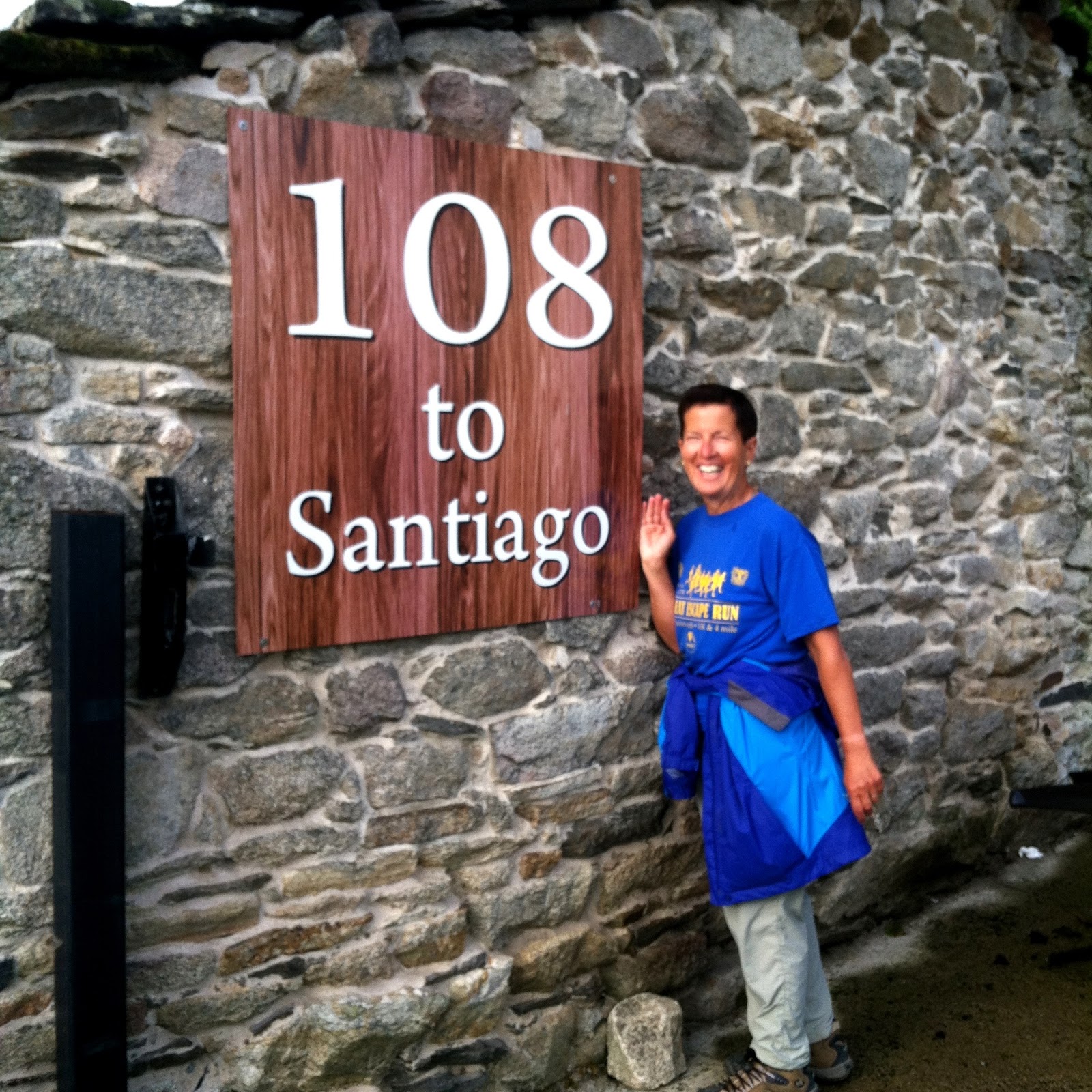
MT 9:48 AM – Barbadelo: MT with “108 to
Santiago” sign.

9:44 AM – Barbadelo: our first hórreo (nothing
special).
On our way out of Barbadelo, we came to the Igrexa de Santiago.

9:55 AM – Barbadelo: Igrexa de Santiago in
distance.

9:58 AM – Barbadelo: sign for “Igrexa de
Santiago de Barbadelo” with text in Spanish and Gallego; Spanish text [translated:
The rehabilitation and enhancement of the Camino Francés to Santiago de
Compostela through Barbadelo, Sarria, Lugo, has been carried out by the Xunta
de Galicia with the collaboration of the Ministry of Development, and the
Ministry of Education, Culture, and Sport through plans and programs for the
conservation of the architectural heritage and the Historical Patrimony “1 %
Cultural.”]

9:58 AM – Barbadelo: sign for “Igrexa de
Santiago de Barbadelo (S. XII)” with text in Gallego, Spanish, and English – (poor)
English part of text: “Santiago de Barbadelo Church (12 nd C.) - Old
benedictinian monast[e]ry (9 th C.). Priorate of Samos until 1835. Monument of
cultural interesting [Spanish: Bien de
Interes Cultural (BIC)]. Romanic Church, 18 th Century apsis [apse].
Portic[o] with eardrum [tympanum] from another older church.”
Interestingly,
there was a coke machine by the
gate.

9:59 AM – Barbadelo: Igrexa de Santiago and
coke machine.

9:59 AM – Barbadelo: coke machine and albergue
advertisement at gate to pathway to church.

10:00 AM – Barbadelo: Igrexa de Santiago
façade with Romanesque portal (mostly hidden) and tower; crosses of cemetery at
left and on wall in front of door.
The Igrexa de Santiago [Church of St. James] in Barbadelo dates from the second half of the 12th
century and is mentioned in the Codex
Calixtinus. It was constructed over the remains of an old monastery. The
area is known locally as O Mosteiro in reference to a monastery
founded here as early as the 9th century; in 1009, it came under the control of
the Monastery of Samos and functioned as a hospital for pilgrims.
The church seen today was built
soon afterward and is the only monastery building that remains. It is one of
the best examples of Galician Romanesque and was declared a Bien de Interes
Cultural (BIC) in 1980. It is dominated by a square fortified tower on its
northwest corner (one of the few such structures preserved in Galicia), and its
portals have sculptures of strange and fantastical animal and human figures
carved with a coarseness that characterizes granite. Its windows and west
(main) door have jaqués taqueado (or jaqués ajedrezado [checkered]) patterns
in the trim, common in the Spanish Romanesque. Regrettably, the original
Romanesque apse was replaced by a rectangular one in the 18th century. The
south wall of the nave was also quite renovated (after a collapse), but the
north and west walls are well preserved along with their portals.

Barbadelo: Igrexa de Santiago – apse, north side,
and tower (gl.wikipedia.org).

Barbadelo: Igrexa de
Santiago - west door (gl.wikipedia.org).

Barbadelo: Igrexa de
Santiago - west door archivolts, capitals, and tympanum (www.wikiwand.com).
The west (main) portal, which stands out from the façade, has a fine tympanum, although greatly degraded; it
is unusual, since it is carved on both sides. On the exterior is a primitive male figure with open arms that may be
Christ (not in the “crucified” mode but in prayer or welcome), flanked by two
small, star-shaped motifs. Below this figure is a pentagonal lintel with a
central image of a figure with the head of a beast or demon flanked by two
serpents pointing to his ears (however, some see this as a Celtic-style laced
knot). To each side of this strange figure are 3 intersecting circles of progressively
decreasing size. The row of pinecones across the bottom of the lintel symbolize
fertility and immortality.

Barbadelo: Igrexa de
Santiago - left capitals of west door (gl.wikipedia.org).

Barbadelo: Igrexa de
Santiago - capitals on right of west door (gl.wikipedia.org).
The west door has 3 archivolts
under a jaqués taqueado (checkered) hood,
the 1st and 3rd resting on decorated capitals, also under checkered hoods. From
left to right, the capitals show: two characters riding monstrous-looking
birds; a pair of lions devouring a person at the corner; two lions with heads
facing each other; a scene difficult to interpret, with (on the outside face) a
character sitting on a throne and receiving another person in front of him on
the corner and (on the interior face) two characters holding up elongated
objects or whips toward the corner. It is likely that these pieces belonged to
an earlier church.
The inside of the west door shows the back side of the same 9 stones seen
on the exterior tympanum. On the pentagonal lintel, there are 5 adjacent
circles decorated with geometric motifs. In the tympanum above it is a cross
with equal arms flanked by two stars (identical to the ones on the exterior).

Barbadelo: Igrexa de
Santiago - north door (gl.wikipedia.org Cropped).
On the capitals below archivolts
of the north door are more strange
and fantastical animals: on the left, two lions face each other; on the right,
each face has a dragon-headed serpent with a twisted body that seem to drink
from a chalice at one end and eat fruits and vegetables at the other. As on the
west door, this one also has a pentagonal lintel, but without any decoration on
the tympanum.
The cemetery surrounding the church is typical of Galicia. Five or 6
stories of rectangular burial niches, constructed similarly to hórreos (and probably by the same
masons), circle the church like a defensive wall. Many bear photographs of the
deceased.
After
Barbadelo, we continued on road through woodland of birch, oak, and chestnut
trees as far as Baxán (pop ?) and
then continued on a country lane through a seemingly endless number of corredoiras (narrow, tree-covered paths
that are enclosed on both sides) with ancient and venerable trees.

10:43 AM – After Barbadelo: MT on stone bridge
above wet path.
A characteristic of Galicia are pasadoiros,
large stone slabs laid in a row to enable pilgrims to cross streams.

MT 10:45 AM – After Barbadelo: Don and other
pilgrims following MT over the stone bridge.

MT 10:48 AM – After Barbadelo: MT and Don on
stone bridge.

10:47 AM – After Barbadelo: looking back over
the stone bridge with water-covered path.

10:47 AM – After Barbadelo: aqueduct near
stone bridge.

10:48 AM – After Barbadelo: sheep that just
arrived by the bridge and aqueduct.

MT 10:49 AM – After Barbadelo: sheep kept coming
closer to path.

11:04 AM – After Barbadelo: yellow arrow on
stone wall, with donkey grazing in background.

MT 11:05 AM – After Barbadelo: same yellow arrow
on stone wall (close up).

11:16 AM – After Barbadelo: Holstein cows
beyond wooden “gate” in stone wall, with yellow arrow.

11:16 AM (Cropped) – After Barbadelo: Holstein
cows beyond wooden “gate” (with thin wire above it, probably electric fence
powered by battery in the blue and yellow box) in stone wall.

11:20 AM – After Barbadelo: MT on wooded path
with moss-covered walls.
Moss-covered
dry stone walls line the route from Barbadelo to Morgade.

11:25 AM – After Barbadelo: fields with dry-stone
fences, through gate.
Near
A Brea (pop 20), there is an
incorrect milestone announcing 100 km to Santiago (it is really 100.5 km). The
correct milestone is not the one at the beginning of the slope, but rather the
one on a flat asphalt path.

11:47 AM – A Brea? : wooden hórreo.

11:50 AM – Near A Brea: 100 km marker stone.
We
reached Morgade (pop ?) around
11:56.
Morgade is a one-house
hamlet with an old wooden hórreo in
front of a dairy shed.
We
got our 3rd sellos of the day at Casa
Morgade (km 99.5), where we bought and split a tuna empenada (2.50€) and ate pan
de leche pastries from breakfast. Our pause there was 25 min.

11:56 AM – Morgade: cows crossing road near
Casa Morgade.

11:57 AM – Morgade: Casa Morgade front.
About
1 km after Morgade is a sign for entering the Concello de Paradela, where we reach the parish of Ferreiros.
We
arrived in Ferreiros [misspelled
Ferrerios on Brierley’s map and elevation chart] (pop 21) around 12:45.
The hamlet of Ferreiros appeared thanks to the
Camino. The village’s name means “blacksmiths.” Ferreira was a blacksmith’s
site where pilgrims could nail their shoes and the ones traveling by horse
could shoe their animals.
300
m after Ferreiros, we came to the nearby village of Mirallos (pop 2 in 2013, now 1), where the Iglesia de Santa María
de Ferreiros is now located. The name Mirallos means “beautiful view.”

12:46 PM – Mirallos: Iglesia de Santa María de
Ferreiros – mausoleum (on left), apse and bell tower.
The Iglesia de Santa María de Ferreiros (Ferreira) is a small church
with a Romanesque façade originally built in the 12th century on the site of a
former monastery. This church maintained a pilgrim hospital, San Mamed de
Ferreiros, under the auspices of the Monasterio de la Magdalena in Arzúa, but
it has since vanished. In 1790, the parish church of Santa María de Ferreiros
was moved stone-by-stone to its present location in the nearby place of
Mirallos, where it now functions as a cemeterial chapel. At the time of the
move, some reforms were made (including the Baroque belfry), but it retained
much of its original Romanesque aspects, primarily on its western façade. The
highlight of the façade is the Romanesque portal with three horseshoe-shaped
archivolts under an ajedrezada [checkered]
chambrana [border?] and supported by
columns with decorative capitals. The most unique element of the portal is the
tympanum, which is supported by corbels decorated with lion heads and is
lightened by two small twin semicircular arches, a pattern that appears in
several nearby churches. In front of the west portal is a baptismal font with
representations of human figures and various symbols.

12:46 PM – Mirallos: Iglesia de Santa María de
Ferreiros – apse and belfry, with cemetery beyond.

12:47 PM – Mirallos: Iglesia de Santa María de
Ferreiros – view through cemetery (with burial niches and mausoleums) to church – façade and bell
tower.

Mirallos: Iglesia de Santa María de Ferreiros façade, belfry, and baptismal
font (concelloparadela.es).

12:47 PM – Mirallos: Iglesia de Santa María de
Ferreiros – belfry.

12:56 PM – Mirallos: MT with pumpkins and
yellow arrow on stone wall.

12:56 PM – Mirallos: MT with pumpkin on stone
wall.

MT 12:56 PM – Mirallos: Don with pumpkin on
stone wall.

MT 12:59 PM – Mirallos: pumpkin on stone wall.
Shortly
after Ferreiros and Mirallos, at 1 pm, we stopped at a private house “La Cansera.” By the gate there was free
fruit and a jug of water. The owner, a Belgian man, came out and showed us how to drink
water from the jug. While there, we met 2 ladies from Ireland who were not
walking with their husbands at that time.

1:02 PM – After Ferreiros: La Cansera – MT and
2 Irish ladies at gate with refreshments; yellow arrow pointing right.

1:02 PM – After Ferreiros: La Cansera – signs
“Espiritu de hospitalidad” [Spirit of Hospitality] and “Ague fresca y reposo
para hacer bien el camino” [Fresh water and rest for doing the camino well].

1:05 PM – After Ferreiros: La Cansera – MT
drinking water from jug with Belgian host looking on.

1:06 PM – After Ferreiros: La Cansera – MT and
Belgian man.

1:36 PM – After Ferreiros: hórreos and end of
flat-stone wall (no mortar).

1:48 PM – After Ferreiros: stone houses and
walls (2 yellow arrows and big old dog at house to right of road).

1:48 PM (Cropped) – After Ferreiros: stone houses and walls (2 yellow arrows and big old dog at house to right of road).
We
stopped again (15 min) at a shop/bar in Moutrás
(pop ?) for a piece of local cheese and ate wafer cookies from breakfast.

1:49 PM – Moutrás: cow and old wooden hórreo.
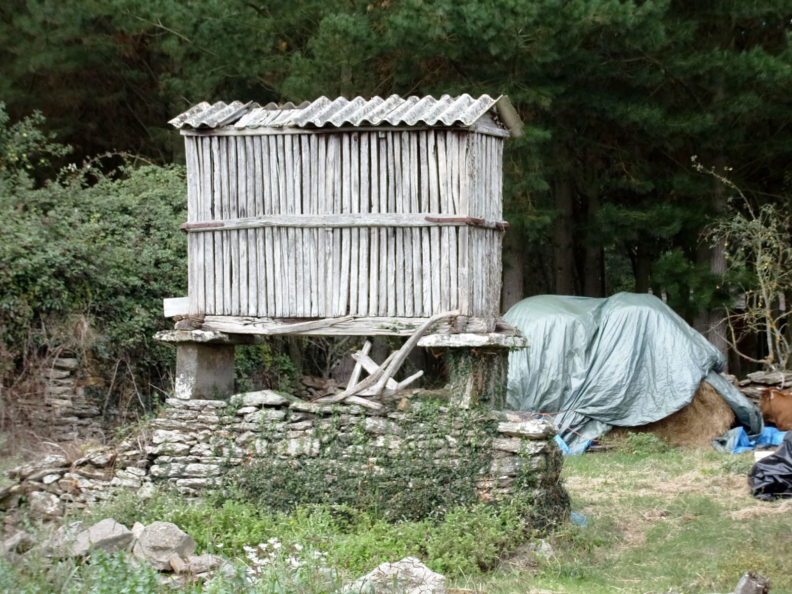
1:49 PM – Moutrás: that old wooden hórreo
(telephoto, 76 mm).

1:51 PM – Moutrás: sign about “Hórreo” with
photo of “Hórreo in Moutrás” and text in English and Spanish – English part reads: “An hórreo is a typical
granary from the northwest of the Iberian Peninsula (mainly Galicia, Asturias
and Northern Portugal), built in wood or stone, raised from the ground by
pillars ending in flat saddle stones to avoid the access of rodents.
Ventilation is allowed by slits in its walls.
Distribution
Hórreos are mainly
found in the Northwest of Spain (Galicia and Asturias) and Northern Portugal.
There are two main types of hórreo:
rectangular-shaped, the more extended, usually found in Galicia and coastal
areas of Asturias; and square-shaped hórreos
from Asturias, León, western Cantabria and eastern Galicia.
Origins
The
oldest document containing an image of an hórreo
is the Cantigas de Santa María by
Alfonso X ‘El Sabio’ (song CLXXXVII), 13th century. In this depiction, three
rectangular hórreos of gothic style
are illustrated.
Hórreo-like
granaries in Europe
Similar
granaries were common throughout Atlantic Europe: Northwest Iberian Peninsula,
France, the British Isles and Scandinavia.
There
are espigueiros or canastros in northern Portugal (the most
famous concentration is located in Soajo).
French
Savoy has its regard, also
encountered in the Swiss Valais (raccard)
and the Italian Aosta Valley (rascard).
Norway has its stabbur, Sweden its häbre or more precisely stolphäbre or stolpbod. Hambars are
found in the Balkans, and serender in
northern Turkey.
Etymology
Hórreo comes from the latin
word horreum (and this from the Greek
term ώρειου, σιτοφuλακειου, απθήκη,
granary), that means: ‘building made to store agricultural products’, specially
grain. The latin word horror, -oris,
horror, has the same root because that buildings were dark and cold.”
(For more on hórreos, see Appendix B of this blog.)
(For more on hórreos, see Appendix B of this blog.)

1:51 PM – Moutrás: another wooden hórreo (same
one pictured on the sign).
(Sometime
during the day, we saw the same ostrich as last year, but not dust-bathing this
time. We also saw the same green door as last year, but this year there were 2
new yellow arrows painted on the corner.)
Rain
started just before we reached Portomarín
(pop 2,171) at 3:30 (we had first seen the town at 2:30). As we prepared to
cross the bridge into the town, there was a group of signs.

3:14 PM – Portomarín: signs just before the
new bridge, informing us that we were crossing the río Miño, which was dammed
up to form the Encoro de Belesar [Reservoir of Belesar]); arrows pointing to
right, across bridge, for Portomarín and the Camino.
The area around Portomarín (previously spelled Puerto
Marín or Puertomarín) has been inhabited for many thousands of years, as the
number of pre-Roman castros in the
vicinity testifies. A bridge over the Río Miño (aka Minho), the largest river
in Galicia, gave life to this town perhaps as early as Roman times. The Romans
occupied it and named it Portumarini
(as cited in 792); so a bridge must have existed then. However, the town is
said to have been founded in the 10th century. In this location, at least from
the year 922, there was a female Monasterio [convent] de Santa Mariña. The town
was already documented in 993 as Villa
Portumarini and was referred to as Pons
Minéa [Bridge on Miño] in the 12th-century Codex Calixtinus. With the discovery of the tomb of St. James, the
town’s importance grew, since this was the only bridge over the Río Miño
(except those of Lugo and Orense). From the 12th century, it was an obligatory
stop on the Camino Francés.
At one time it had 3 orders of
knights: Knights Templar, Knights of Santiago, and Knights of St. John of
Jerusalem. The nearby Monasterio de Santa María de Ribalogio (or Santa María de
Loyo) was present in the first half of the 10th century (its ruins are on the
banks of the Río Loyo 3 km from the old town of Portomarín) and belonged to the
religious-military order of Caballeros de la Espada [Knights of the Sword],
founded in the 12th century, which gave birth to the Order of Knights of Santiago
(also known as the Caballeros de la Orden de Santiago de la Espada [Knights of the
Order of St. James of the Sword]). When the Order of Santiago was chartered in
1170, Portomarín was given to those knights. In 1188, King Alfonso IX
transferred ownership to the Order of San Juan de Jerusalén, which for
centuries maintained a facility and pilgrim hospital there. During the Middle
Ages, this was a strategic Jacobean enclave, with a great bridge and several
pilgrim hospitals. Its strategic location made it a special place of rest and
provisioning for pilgrims on their way to Santiago. Its greatest Jacobean
splendor was in the 10th to 12th centuries. The town grew along both banks of
the Miño and became an important commercial and military center.
The old town (Viejo Portomarín) was divided into two barrios (neighborhoods, boroughs,
districts), San Juan and San Pedro, on each side of the río Miño. San Juan was
the principal population center, situated on the right (north) bank of the
river, having much greater importance than San Pedro on the left (south) bank.
Both barrios had Romanesque churches,
of which that of San Juan was the more important. In the Middle Ages, the two barrios together had a population of
around 1,200.
The original bridge joined the southern district of San Pedro (with links to the
Knights of Santiago) with the northern district of San Nicolás (headquarters of
the Knights of St. John). The river formed a major strategic boundary, and
consequently the area had a turbulent past. The bridge—a key control point on
the major east-west highway across northern Spain—has been built and destroyed
many times.
In the 2nd century, the Romans
built a bridge across the río Miño. The Roman bridge was 152 m long and 3.3 m
wide. That bridge was used by the Swabians and Visigoths for their invasions. In
997, Moors under Almanzor ravaged the area and presumably destroyed the bridge.
It was rebuilt, but was later destroyed around 1112 by Queen Urraca of Castilla
to prevent her husband Alfonso I’s troops from advancing; in 1126, she ordered
a new one built. The bridge was linked to the Encomienda [residence of the
knight-monks] of the Order of San Juan and the pilgrim hospital named Dominus
Dei [House of God], which was also commissioned by Urraca in 1126. (The
hospital was demolished in 1944.)
The medieval bridge gradually
disappeared with the collapse of the central arch in 1895 and the later loss of
some more arches, leaving only one arch in the middle of the river and one on
the embankment of the barrio San
Juan. Those arches remained in the 1950s. A newer bridge was built in 1929.

Portomarín: old bridge
with 3 south arches intact in 1929 (view from SE); S side of Igrexa de San
Nicolás on far bank (portomarinvirtual.es).

Portomarín: 1929 bridge with old town and two pieces of Roman/medieval bridge in background (view from SE); S side of Igrexa de San Nicolás on far bank (portomarinvirtual.es).

Portomarin: old town with Iglesia de San Nicolás and arch of medieval bridge (portomarinvirtual.es).

Portomarin: old town with Iglesia de San Nicolás and arch of medieval bridge (portomarinvirtual.es).

Saturday, September 20,
2014, 8:26 AM – Portomarín: photo from 1950-53 of old town and bridges (in El
Caminante bar).

Portomarín: better copy of
same 1950-53 photo; view from SE of 1929 bridge (in foreground) and remnants of
old Roman/medieval bridge (in background); S side of Igrexa de San Nicolás on
far bank (portomarinvirtual.es).
In the 19th century, the rapid
growth of the city of Lugo, 30 km to the north, and the development of a
highway system that centered there, cut Portomarín off from the commercial
flow, and the town withered. In fact, as late as 1919, not a single road that
could accommodate wheeled traffic reached the town. In 1931, the Romanesque Igrexa
de San Juan (later San Nicolás) was declared a National Monument. In 1946, the
original town was declared a Conjunto (or Pueblo) Histórico-Artístico [historic-artistic
unit (or town)] for special conservation by General Franco. In 1950, the barrios of San Juan and San Pedro
together had a population of only 745 (versus 1,200 in the Middle Ages).
However, General Franco, in the
interests of progress and prosperity, decided to build a hydroelectric dam near
the town of Belesar 40 km down the river to create the huge Embalse de Belesar (Encoro de Belesar
in Gallego) reservoir, started in 1956 and completed in 1963. Unfortunately,
the 50-m-long reservoir would flood nearly 5,000 hectares (12,355 acres) of
fertile land and would bury the town of Portomarín under its waters. So the
town had to be moved to higher ground.
The site chosen for the new town (Nuevo Portomarín) was on the
nearby hill called Monte de Cristo (O
Cristo in Gallego) with a maximum elevation of 467 m and separated from the
location of Viejo Portomarín by the arroyo Torres. The relocation considerably
raised the elevation of the town above the maximum level of the reservoir. The
streets of the new town were designed to reflect the characteristics of the
past. After the construction of the reservoir, the population of the town declined
considerably, but has slowly recovered. Thus, Portomarín is a new town, mostly
dating from the middle of the 20th century, built when the old one was
submerged under the waters of the new reservoir Embalse de Belesar.
We
entered the town over a modern bridge over the deep Miño basin. However, there
are still remains of earlier bridges.
At the time of inundation by the
reservoir, only one arch of the Roman/medieval bridge remained in the middle of
the river; the arch on the abutment of the barrio
of San Juan was moved to Nuevo Portomarín.
When the dam, built by political
prisoners, was completed in 1963, the dammed waters filled the wide valley
around the Río Miño so that the old town of Portomarín now lies beneath the
waters of the reservoir. The Igrexa de San Nicolás was disassembled
stone-by-stone and moved up the hill to its present location. So was the façade
(or just the balcony) of 16th-century Casa del Conde [palace of the count],
which now serves as the town hall, and the Romanesque façade of the 12th-century
Iglesia San Pedro. However, the ancient pilgrim hospital and most of the
medieval bridge were buried under the water. When the reservoir and the river
are low, typically in the fall, the ruins of the old town, with its houses,
streets, mills, eel traps, and one pillar of the old Roman bridge, as well as
the bridge built in 1929, can be seen sticking up through the blanket of mud. From
2010 to 2012, the reservoir was drained in order to make repairs on the dam,
revealing even more of the old town.
We did not visit Igrexa de San Pedro, which it is no longer on the Camino route through the city. However, it warrants some attention here.
The Igrexa de San Pedro [Church of St. Peter] dates from the 10th
century, but it was not consecrated until 1182. It has always belonged to the
Diocese of Lugo, never having been an autonomous church dependent on knights,
as was San Nicolás (San Xoán). The Romanesque church is built of granite
masonry. In the 17th century, it was modified, adding the Baroque belfry and
giving it a new look. It was declared a historical monument in 1946.
In the old town, it was located in the center of the southern barrio of San Pedro, facing the street
of the same name, on which pilgrims entered the town.

Portomarín: old photo
(from S) showing belfry of Igrexa de San Pedro on near (S) bank; S side of
Igrexa de San Nicolás on far (N) bank; and one arch of old Roman/medieval bridge
in middle of river (portomarinvirtual.es).

Portomarín: Igrexa de San
Pedro at end of narrow street in old town (portomarinvirtual.es).
The façade with its Romanesque
portal was transported into the new town
on the north bank, where was repositioned on a small church about 170 m north of
San Nicolás in a garden area in which it can be admired from all angles. Although
officially still listed as a parish, in practice it is merged with San Nicolás.

Portomarín: Igrexa de San
Pedro – façade (commons.wikimedia.org).
The Romanesque portal, dating from the 10th century, has a semicircular
arch with three semicircular archivolts supported by 6 columns topped by
capitals. The outer 2 of 3 capitals on each side are decorated with floral
motifs; the inner one on the left shows two birds facing one another, and the
inner one on the right shows two griffins facing one another. The tympanum has
no sculpture but once had an inscription (now virtually illegible) saying the
church was consecrated in 1182 [or 1188?], which was discovered under layers of
plaster then the façade was transferred to the new town and restored. However,
the tympanum has two small arches decorated with small lobes (star-shaped semicircles)
at its bottom edge and rests on mochetas
[corbels?] shaped like bull’s heads. The archivolts are covered with geometric
patterns.

Portomarín: Igrexa de San
Pedro - left capitals of Romanesque portal (commons.wikimedia.org).
We
crossed the long, modern bridge over the
dammed Río Miño into Portomarín. Walking over the new bridge, one can see the remains of the old bridges and walled
lanes leading out of the submerged old town.

3:13 PM – Portomarín: new bridge, with 1929
bridge below it on right and some foundations of old town on far (north) bank
visible at low water level.

3:13 PM – Portomarín: Igrexa de San Nicolás
from across the river (telephoto, 133 mm).
At
the far end of the modern bridge, we had the choice of turning left or right on
the Avenida de Sarria or following the old Camino route by taking the 46 steps
of the Escalinata Nuestra Señora das Nieves that lead up to the Capilla
de Santa María de las Nieves, rebuilt over an arch of the Roman/medieval
bridge.

3:19 PM – Portomarín: MT at bottom of
staircase and chapel Capilla de Santa María de las Nieves at top (rain had just
stopped).
The Capilla de Santa María de las Nieves (Gallego: Capela de Santa
María das Neves) [Chapel of St. Mary of the Snows] is from the 12th to 15th
centuries. Locals believed that the Virgen de las Nieves [Our Lady of the
Snows] protected them from drowning and therefore built a shrine to her partway
across the old bridge in the Middle Ages. The original image of the Virgen de las
Nieves from the chapel was placed in the tollhouse of the Roman/medieval
bridge. Due to the ruinous state of the chapel, the statue was moved to the
Igrexa de San Nicolás. However, its whereabouts are unknown since the
relocation of the village.
The chapel is constructed of
masonry with a single aisle and a belfry on the façade. It was built over the
last arch of the Roman/medieval bridge, and above a vaulted passage in the
lower part, through which pilgrims had to pass in order receive a benediction
to pass the last arch and enter into the barrio
of San Juan. In “O Paso” [the passage], there was a tollhouse for collecting
the toll. This chapel thus became an obligatory point in order to continue the
Camino to Santiago. After Doña Urraca rebuilt the bridge in 1126, the
Cistercian priory of Rivas de Miño was created, where the Benedictine monks
received pilgrims who could not pay the toll.
During the construction of the
dam that formed the Belesar reservoir, the townspeople moved the Virgen de las
Nieves chapel (and tollhouse), along with the northernmost span of the old
bridge, to the north end of the new bridge on the high ground around Nuevo Portomarín;
the move was completed by 1962. Pilgrims can now climb the 46 steps of the
steep Escalinata Nuestra Señora das Nieves [Staircase
of Our Lady of the Snows], built into part of the original Roman/medieval
bridge, up to the Capilla de Santa María
de las Nieves, through which they enter the new town.

MT 3:21 PM – Portomarín: MT by Capilla de
Santa Maria de las Nieves and signs at bottom of staircase, indicating that one
can get to Igrexa de San Nicolás without climbing the steps, by turning right
on Avenida de Sarria.

Portomarín: old photo of Capilla de Santa María de las Nieves and arch of old
bridge with 1929 bridge in background (portomarinvirtual.es).

3:24 PM – Portomarín: MT and others at top of
steps (Don’s walking poles at bottom).

3:25 PM – Portomarín: MT and others by arch of
“O Paso” tollhouse and Capilla de Santa María de las Nieves at top of steps.

MT 3:25 PM – Portomarín: Don
starting up steps.

3:26 PM – Portomarín: looking back down steps
and across bridge; remnants of old houses on far (S) bank.
We
found Albergue Turistico El Caminante,
which included the Pensión El Caminante
[the Walker] with double room for 42€ including breakfast. We got our 4th
sellos of the day “Pensión El Caminante.”

3:45 PM – Portomarín: Pensión El Caminante –
MT in our room (No. 202).

3:46 PM – Portomarín: Pensión El Caminante –
our room (No. 202).

3:52 PM – Portomarín: Pensión El Caminante –
Don’s Keen shoes getting bad in heels.

3:55 PM – Portomarín: Pensión El Caminante –
terraza with washer and drier, between algergue and pensión parts (from our
window).
The
shower in our room was really strange. There was no shower stall, door, or
curtain—just a drain in the floor. After MT’s shower, the bathroom floor was
very wet—a veritable lake. A lady came and mopped it up.
We
put our laundry in the 4€ washer and went out to look around town and find a
place to eat.
However,
we first visited the Igrexa de San
Nicolás, which we had first seen when crossing the bridge and again from
our room.

3:55 PM – Portomarín: Pensión El Caminante –
view of Igrexa de San Nicolás from our window (slate roof on building in
foreground).
The 12th-century Romanesque fortified
church Igrexa de San Nicolás was
originally known as the Igrexa de San Xoán (San Juan). The locals sometimes
still refer to it by its old name. It
was built by the Knights of St. John of Jerusalem, who also controlled the
bridge across the río Miño and one of the pilgrim hospitals. The mission of the
church was to protect the bridge, pilgrims, and traders. In the old town, it
was strategically located beside the river on Calle Santa Isabel, the main
street of the barrio of San Juan.
When the original town was about
to be submerged under the new reservoir, the church was dismantled stone by
stone, moved from its original site to its present town center position, and painstakingly
rebuilt. The 16,000 stones were numbered to aid reconstruction, and the numbers
can still be seen. As part of the reconstruction, the towers (the two on the
south side had disappeared) and battlements were restored to their original
form, and a sacristy added to the apse in 1629 was removed in order to recover
a pure Romanesque style. The transfer and reconstruction took 4 years
(1960-1964).
The church has four towers and
battlements on top and looks more like a castle keep than a place of worship,
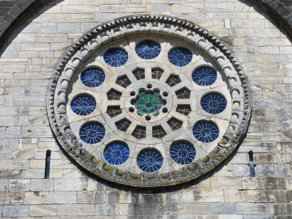
although its militaristic outline is softened by a magnificent rose window (at
both ends) and three carved portals with rich sculptural decoration. Most
sources say this church is the work of a student of Master Mateo (who built the
Portico de la Gloria of the Santiago Cathedral), whose influence can be seen
most clearly in the style of the main portal. The church is considered one of
the best Romanesque works of the Lugo region due to its elegance and sobriety.
However, rosettes on both gables provide not only light but
also signal the imminent arrival of the Gothic. The church is built of granite,
probably quarried in the valley of Río Loyo 3 km from Portomarín. Until the
19th century, it remained an independent enclave (a “diocese Nulius”) within
the Diocese of Lugo, governed by the military order and not under the authority
of the Bishop of Lugo.

5:23 PM – Portomarín: Igrexa de San Nicolás – west
façade.

Portomarín: Igrexa de San Nicolás – rose window on west façade (https://c2.staticflickr.com/4/3901/15115408022_7f43d9ef6f_b.jpg).

Portomarín: Igrexa de San Nicolás – rose window on west façade (https://c2.staticflickr.com/4/3901/15115408022_7f43d9ef6f_b.jpg).

5:34 PM – Portomarín: Igrexa de San Nicolás – main
portal in west façade.
The main (west) portal is influenced by Master Mateo’s Portico de la
Gloria. On its tympanum is the Pantocrator (Christ in His Majesty) on a
mystical mandorla (almond). [According
to www.monestirs.cat, the figure in the
mandorla is San Nicolás.] The inner archivolt shows ancient musicians with
their instruments, clearly following Mateo’s model. [According to www.portomarincidre.blogspot.com,
these are the 24 elders of the Apocalypse with their instruments, seated in a
semicircle, as in Santiago.] The mochetas
[corbels?] supporting the tympanum are decorated with an angel on the right and
a winged monster on the left. During the transfer of the church, the figures on
this portal were covered with plaster to protect them.
In medieval times, this portal
was a mandatory entrance for pilgrims who wanted to complete the last stretch
of the Camino, after receiving the blessing bestowed by Papal Bull as they
passed through the tollhouse of the Roman bridge and the Capilla de las Nieves
atop it. Today, this portal is not used on a regular basis, with entry through
the south portal.

5:34 PM (Cropped) – Portomarín: Igrexa de San
Nicolás – main portal in west façade – tympanum with semicircle of seated musicians
with their instruments.

Portomarín: Igrexa de San Nicolás – main portal in west façade – archivolt with semicircle of seated musicians with their instruments (commons.wikimedia.org).

Portomarín: Igrexa de San Nicolás – main portal in west façade – archivolt with semicircle of seated musicians with their instruments (commons.wikimedia.org).

Portomarín: Igrexa de San Nicolás – main portal in west façade – archivolt with semicircle of seated musicians with their instruments (commons.wikimedia.org).

Portomarín: Igrexa de San Nicolás – main portal in west façade – archivolt with semicircle of seated musicians with their instruments (commons.wikimedia.org).

Portomarín: Igrexa de San Nicolás – main portal in west façade – archivolt with semicircle of seated musicians with their instruments (commons.wikimedia.org).

Portomarín: Igrexa de San Nicolás – main portal in west façade – archivolt with semicircle of seated musicians with their instruments (commons.wikimedia.org).

5:32 PM – Portomarín: Igrexa de San Nicolás – south
side door where we entered for mass.
The tympanum of the south portal shows three figures whose
identity is uncertain. In the center is a bishop wearing his miter (probably
San Nicolás). To his sides are two acolytes, one carrying a broken stick and
the staff of the bishop and the other an open book. The sculpture of the
capitals is indebted, as is all of the church, to the style of Master Mateo,
with harpies and monstrous beings typical of the late Romanesque period.

Portomarín: Igrexa de San Nicolás - tympanum of south portal
(commons.wikimedia.org).

5:31 PM – Portomarín: Igrexa de San Nicolás – S
side entrance, east gable with rose window, and semicircular apse.

6:39 PM – Portomarín: Igrexa de San Nicolás –
numbered stones of reconstructed side of apse to right of entrance door.

Portomarín: Igrexa de San Nicolás - north portal (commons.wikimedia.org).
The north portal has a tympanum showing the Annunciation. The Archangel
Gabriel announces to Mary her transcendental destiny. With her hands raised and
palms forward, she gives her assent. Between Gabriel and Mary, a small tree
with three leaves and two fruits, which some experts say evoke the Trinity and
the dual nature of Christ. The capitals, in Mateo’s style, show monstrous animals
and harpies.

Portomarín: Igrexa de San Nicolás - north portal tympanum
(gl.wikipedia.org).
Across
the main square Praza Conde de Fenosa from San Nicolás (to the left) was the City Hall (Casa de Consello, formerly
Pazo del Conde da Maza) and a pilgrim statue.

5:24 PM – Portomarín: City Hall with banner
for “Domingos Folcloricos de Portomarín” [Folklore Sundays of Portomarín] (note part of banner reflected in wet pavement in foreground) and pilgrim
statue to right.

5:24 PM – Portomarín: statue of pilgrim
pointing the way to the Camino; plaque in Gallego reads: “Xunta de Galicia –
Este peregrino fui inaugurada o 27 de Decembro do ano 2001 polo Conselleiro de
Cultura Comunicación Social e Turismo …” [Government of Galicia: This pilgrim
was inaugurated on December 27, 2001 by the Council of Culture, Social
Communication, and Tourism …(with names of the Galician Minister of Culture and
Communication, the Xunta de Galicia president, and the mayor)].

MT 5:25 PM – Portomarín: MT and Don with pilgrim
statue.

5:38 PM – Portomarín: MT on main street, rúa
Xeral Franco (Calle General Franco) W of San Nicolás with colonnades.
We
went to eat the 10€ menu at Restaurante
Mesón de Rodriguez (where we had eaten last year): 1st course: both had caldo gallego; 2nd course: both had merluza con salsa verde [hake with green
sauce] (with salad vice fries); dessert: MT asked for cheese with (quince)
marmalade/Don tarta helada [ice cream
cake] (vanilla ice cream with chocolate stripes in center but no caramel).

5:32 PM – Portomarín: Restaurante Mesón de Rodriquez
under colonnade E of San Nicolás apse.

6:08 PM – Portomarín: Restaurante Mesón de Rodriquez
- 10€ menu in Spanish and English.

6:10 PM – Portomarín: Restaurante Mesón de Rodriquez
– MT with caldo gallego, bread, and
local wine (label of Hotel Villajardín where we stayed last year, around the
corner).

6:19 PM – Portomarín: Restaurante Mesón de Rodriquez
– Don’s merluza con salsa verde (and
salad).

MT 6:40 PM – Portomarín: Restaurante Mesón de Rodriquez
– Don at table under colonnade.

MT 6:50 PM – Portomarín: Restaurante Mesón de Rodriquez
– sign under colonnade: “La cuba de buen Vino no necesita Bandera” [The vat of
good wine does not need a flag] (signed P. Rodriguez).
Back
at Pensión El Caminante, we moved
our laundry from the washer to the 4€ dryer. At that time, the sun was shining
on Igrexa de San Nicolás.

MT 7:39 PM – Portomarín: Igrexa de San Nicolás –
view from our room in pensión (just before sun came out).

7:45 PM – Portomarín: Igrexa de San Nicolás –
view from our room in pensión (with sun).
Then
we went to mass at 8 pm at Igrexa de San
Nicolás. There was a pilgrim blessing at the end of mass, and we got our 5th
sellos of the day: “San Juan Portomarín.”

Portomarín: Igrexa de San Nicolás - interior of nave toward apse and E rose
window (commons.wikimedia.org).

Portomarín: Igrexa de San Nicolás - right (S) rear of nave with light from
W rose window and statue of John the Baptist above baptismal font (photo from Eliza Linley).

8:29 PM – Portomarín: Igrexa de San Nicolás –
statue of John the Baptist (in poor light) above baptismal font at right rear
of nave, where we got sellos after mass.
The baptismal font at the rear of the right side of the nave rests on a
bundle of columns with a relief of meandering foliage. In the Middle Ages,
baptismal fonts were linked to baptism by immersion, until baptism by infusion
was instituted in the 15th century.
No comments:
Post a Comment