
7:00 AM – La Laguna de Castilla: Bar-Albergue A Escuela – Don’s Keen walking shoes, showing more signs of wear.

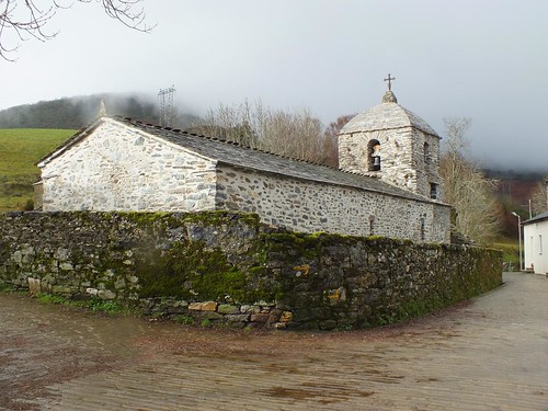
7:48 AM – La Laguna de Castilla: Bar-Albergue A Escuela – exterior, illuminated at 7:48 am (with flash).

7:48 AM – La Laguna de Castilla: Bar-Albergue A Escuela – exterior, illuminated at 7:48 am (without flash).

7:48 AM – La Laguna de Castilla: Bar-Albergue A Escuela – exterior of bar (people eating breakfast inside) and rooms above (albergue).

7:48 AM – La Laguna de Castilla: Bar-Albergue A Escuela – exterior steps and ramp to rooms upstairs.

7:48 AM – La Laguna de Castilla: Bar-Albergue A Escuela – doors to our room (No. 104) and our (private) bathroom.

7:57 AM – La Laguna de Castilla: Bar-Albergue A Escuela – view of threatening sky (to W) from our window.
We ate breakfast at A Escuela bar (4€ each): coffee/hot chocolate; 2 tostadas con mermelada (toast with marmalade).
We departed at 8:20 am in a drizzle. We walked most of the day in rain, light to heavy, with only short bits of sun and dry.
From here to O Cebreiro, the Camino climbs through brushy, open country dominated by white broom, laburnum, and gorse, with occasional groves of scrub oak.

8:32 AM – After La Laguna de Castilla: MT on rocky path.

MT 8:35 AM – After La Laguna de Castilla: view to S.
Just 700 m above La Laguna de Castilla but still 400 m from the border, we passed the first Galician-style concrete Camino marker post inscribed with the distance to Santiago “K.152,5” and the place name “Os Santos” [Teso dos Santos, meaning hilltop of the saints].

8:36 AM – After La Laguna de Castilla: 152.5 km marker (Galician style).
There was once a small chapel at Teso dos Santos marking the border between León and the Lugo province of Galicia. Perhaps that is why Don Elias Valiña Sampedro of O Cebreiro started here with his Galician-style marker posts.
We would see these markers all the way to Santiago, counting down every 500 m and inscribed with the name of the nearest village, parish, or municipality. The route had been changed since they were originally surveyed; so the distances were no longer accurate; but at least they assured us that we were on the right track.

8:40 AM – After La Laguna de Castilla: view to N.

8:40 AM – After La Laguna de Castilla: MT on rocky path, uphill.
Just before O Cebreiro, we reached the Galicia frontera (border), with a larger marker announcing that we were leaving (the León province of) the autonomous region of Castilla y León to enter (the Lugo province of) Galicia. We were SO happy to finally be in the same region as Santiago.

8:45 AM – Galicia border marker.

MT 8:46 AM – MT with Galicia border marker.

MT 8:48 AM – Don with Galicia border marker.
Galicia (Galiza in the local Galego language). The Valcarce valley and O Cebreiro provide a foretaste of the distinctive Galician culture. The mountains of Galicia are the first object in 5,000 km that the westerly winds coming off the Atlantic hit; so there is an immediate change in weather with frequent rain showers and thunderstorms and thick mountain fog—reminiscent of other Celtic lands, particularly the west of Ireland. Galicia is Spain’s greenest region. Galicia and its people retain many traces of the Celts, who swept through from 900-600 BC and did not relinquish their hold on this land until the arrival of the Romans in 137 BC. The name Galicia derives from the Latin Callaecia, later Gallaecia, related to the name of an ancient Celtic tribe that resided here and coexisted with the Romans for 3 centuries, the golden age of Celtic culture. The Romans called these people Gallaeci and then applied their name to all the other tribes in the northwest who spoke the same language and lived the same lifestyle. The Celtic character of this land is evident in the Galicians’ favorite traditional instrument, the bagpipes.
Hundreds of ruined hilltop castras [Spanish: castros], or fortified Celtic settlements, survive. Even before the Celtic centuries, the native people lived in pallozas, conical-shaped stone houses with thatched roofs. Galicia’s population remains overwhelmingly rural; 3 out of 10 Galician families live off the land, the highest proportion of any European region. Galicians are also renowned for their belief in magic, witches, and superstition. In many cases, this pagan belief in the spirit world has grafted itself onto Christianity.
Isolated from the rest of Spain by a bulwark of mountains on the east and south, Galicia remained relatively free from Muslim influence. Always visible to the south are the country’s wildest mountains, the jagged Picos de Europa. Galician culture showed greater affinity for Portuguese culture than for that of Spain until the final separation of the two countries in 1668. Galicia came under the rule of the Catholic Monarchs (Ferdinand and Isabella), who established the Junta of the Kingdom of Galicia in 1495. By that time, Galicia had firm economic and religious ties to the central kingdom (Spain) because of the importance of Santiago de Compostela as a pilgrim destination.
A regional herd of a million dairy and beef cattle provide superb meat and milk; the latter is used to make farmhouse cheeses such as the semi-soft breast-shaped queixo tetilla. Beside tapas, seafood is a particular delight: pulpo a Gallego (tender octopus), pulpo a feira (boiled or broiled octopus), and scallops are famed. Those savory fish and meat pies called empenadas, usually stuffed with salted cod or tuna although sometimes with shellfish or pork, are native to Galicia, as is the famous lacón con grelos (cured pork shoulder with turnip tops and chorizo sausage). The best Galician wine is the fruity, full-bodied, white Albariño, perfect with seafood. The acidic and slightly sparkling Ribeiro wine, the popular everyday wine of Galicia, is often served in a ceramic bowl or up. Asturias is known for its sidra (hard cider), served carbonated or still; but this is also common in Galicia.
Thick hot soups (caldo gallego) and rich vegetable and meat stews are typical cuisine. Nearer to the coast, fish dishes such as pulpo a la gallega (steamed octopus dusted with paprika) and mariscos (shellfish) will dominate. Common desserts are queso y membrillo (local cheese with quince jelly) and the famous tarta de Santiago (almond cake dusted with powdered sugar outlining the shape of the cross of Santiago). Wooden and stone granaries (hórreos) are everywhere, for storing the local harvest (primarily corn maíz) out of reach of rat and rain. Galicia is very green because it rains so often.
Caldo gallego in Spanish (or simply caldo in Galician) is literally Galician broth, a traditional soup dish from Galicia. Ingredients include repollo (white cabbage) or other greens [kale, verzas (collard greens), grelos, or navizas/nabizas (sweet turnip greens)]; potatoes; white beans; and unto (lard). Additionally, it can contain garbanzos (chickpeas), fatty pork, chorizo [sausage], ham, or bacon (compagno).
Galicia also has its own language, Galician (Gallego in Spanish or Galego in Galician). It is the westernmost of the romance languages, having split off from Latin in the early Middle Ages. During the Reconquista, in the 11th and 12th centuries, Galicia pushed south into what is now Portugal; today, the southern dialect of Galician is called Portuguese. Gallego was considered the elegant court language in León as late as the 13th century. Troubadours sang Galician songs in the great halls, and King Alfonso X used the language for his Cantigos to the Virgin.
Signs in (and near) Galicia are most often in the Galician language rather than Castilian Spanish. The most notable spelling differences are that X replaces J, as in Xunta (junta) or Perexe (Pereje); R replaces L, as in praia (playa) or praza (plaza); EI replaces E, as in cruceiro (crucero); O replaces UE, as in porta (puerta), fonte (fuente), or ponte (puente); Ñ replaces N, as in camiño (camino). Other differences are, o/os (el/los), a/as (la/las), do/dos (del/de los), da/das (de la/de las), no (en el), co (con el), unha (una), e (y), and use of igrexa (iglesia); a logo (hasta luego). The Xunta de Galicia has a web site for translating Galego to Spanish or English and vice versa: www.xunta.es/tradutor.
In the 1991 census, a massive 91% of inhabitants said they were able to speak Galego, the region's Portuguese-like language. Galego tends to be heard more in rural areas, and it is still thought of as an old person's language. After Galicia was granted autonomous government in 1981, the study of the language took off.
Galician music is firmly Celtic, and perhaps nothing shows the links begtween northern Celtic ntions and Galicia better than the gaita (Galician bagpipe).
In Galicia, municipios [municipalities] are called concellos, which break down into different parroquias [parishes] that in turn contain towns and villages.
The province of Lugo, in the northeastern part of the automonous community of Galicia, is the largest province in Galicia. It is crossed by the western foothills of the Cordillero Cantábrica range and the Galician massif, interspersed with valleys dotted with hamlets. Principal sources of income are agriculture, production of foodstuffs, and fishing. Lugo is one of the main Spanish producers of rye and potatoes, but cattle and pig breeding re more important economically. It is also one of the major timber-producing regions in Spain.
The province takes its name from its major city, Lugo. The city was probably founded by Celtic inhabitants of the region and dedicated to Lugh (aka Lug or Lugos), a pan-Celtic god of light, who was venerated in these lands in pre-Roman times. Others believe that the primitive inhabitants of Spain gave it the name “Luc,” which means “thick forest,” undoubtedly because lush forests covered the territory where it was founded. It was later conquered by the Romans in behalf of Caesar Augustus, and they founded a town they called Lucus Augusti in 13 BC on the site of a military camp set up around 25 BC. The Romans, according to the nature of their language, added to the name “Luc” the ending “us,” thus forming the Latin word lucus that means “sacred grove or woods.” The second part of the Roman name was in honor and memory of Caesar Augustus, to whom the inhabitants attributed the city’s foundation.
It was the most important Roman town in what became Gallaecia during the Roman period. It was the seat of a conventus, one of three in Gallaecia, and later became one of the two capitals of Gallaecia. The Conventus Lucensis contained 16 tribes, mostly Celtic. Lucus was the seat of a bishopric by the the 2nd or 3rd century. It was a stopping place on the road between Braccara Augusta (later called Braga) and Asturica Augusta (Astorga).
The Swabians seized power in the city in 460. Under their rule, the city played an important role as an administrative and religious center; Galicia was divided into two metropolitan archdioceses: one in Braga (the capital of the Swabian kingdom) and the other in Lugo. The Swabian kingdom converted to Catholicism in 560. In 585, Swabian domination gave way to the Visigoths, who returned the kingdom to its former Arianism brand of Christianity. Lugo remained an important administrative center under the Visigoths. In 713 (or 714), the city was attacked and taken by Muslim troops, and soon was virtually deserted. The Muslims did not retain control for long, because in 740 (or 745 or 746) the Asturian King Alfonso I reconquered the city and instructed the Mozarabic Bishop Odoario to repopulate it. During the second half of the 8th century and the beginning of the 9th, Lugo was the main city of the region. However, its hegemony fell in 813, when the tomb of St. James was discovered. As the city of Santiago grew around this tomb, the prosperity of Lugo diminished. 10th-century attempts at rebuilding suggest that Lugo remained a town on paper only: the seat of a bishopric, administered by a count. The city suffered further Muslim attacks in 997. Also, a raid by the Normans almost completely destroyed the city. In the late Middle Ages, King Alfonso VI again started the repopulation. During the Middle Ages, Lugo, like Santiago de Compostela, was a center of pilgrimage.
During the modern age, Lugo had a certain supremacy in the region, although other nearby towns disputed it. It was not until the division of Spain into provinces in 1833 and the creation of provincial governments that Lugo has become the most important town of the province of Lugo, because of its capital status.
The path continued through gorse and scrubland to O Cebreiro.
We reached O Cebreiro (pop 167, altitude 1,339 m) at 9 am. We did not stop there, since we had spent a night there in 2013. Also, the rainy weather was not good for sightseeing or photos.
The tiny village of O Cebreiro has 20 houses developed from and for the pilgrimage. It is a high point (in more than one sense) of the pilgrimage despite its recent development as a popular tourist venue. It is one of the most unusual villages on the Camino, still reflecting its ancient origins.
NOTE: Although some English-speaking sources, such as Brierley carry the Celtic link to Ireland a bit too far by placing an apostrophe in “O’Cebreiro,” the correct spelling (in Castilian Spanish or in Galician) is O Cebreiro; the CSJ guidebook gets it right).
The origin of the name of the town is a matter of some debate. Some sources say it comes from cebrarium, a place with many wild donkeys (Spanish and Gallego: asnos, also called onafros and cebros) and wild horses, plus the suffix –arium. Other sources say the name refers to zebro or enzebro, an animal similar to a zebra but without stripes, once very abundant in Galicia until its extinction in the 14th century due to hunting for its skin. Others say it could be of Celtic origin, meaning backbone, referring to the mountains around the municipality. Others point out that in the Gallego language, cebra also means the blowing of wind and cold rain, with perhaps a different etymology connected to the Latin zephyrus (wind). O Cebreiro was mentioned in a document from 569. The Igrexa de San Xoán in nearby Hospital da Condesa belonged to the jurisdiction of O Cebreiro and was mentioned in 1207 as hospitallis monte Zebruario. In the 12th-century Codex Calixtinus, it is cited as Mons Februarii, saying there was a hospital on top of the mountain.
This area, at the top of the Cebreiro pass (1,293 m), has been occupied since ancient times. Before the arrival of the Romans, there was a Celtic settlement here. A Roman way station here protected the road through the mountains into Galicia. A battle here in 968 kept Norman pirates from entering Castilla. However, the town did not come to life until the era of the Camino. The first pilgrim hospital here was built in the mid-9th century and was run first by monks from the French abbey of St. Gerard of Aurillac, but soon after by Benedictine monks of the Order of Cluny, from the 11th century until 1854.

O Cebreiro: Iglesia Santa María (de.wikipedia.org).
The 9th-century Romanesque Iglesia de Santa María Real do Cebreiro (mass at 7 pm) is the oldest extant church associated directly with the Camino. It is all that remains of the 9th century monastery Santuario de O Cebreiro. The church was founded by Benedictine monks but came under the control of French monks in the 11th century when King Alfonso VI gave the monastery to the French order; the Catholic Monarchs Ferdinand and Isabella gave it back to the Benedictines. The monastery was abandoned in the 19th century. The church has relics including a 12th-century statue of the Virgin (Santa María la Real), the patroness of the area. Outside the church is a bronze bust of the late parish priest, Don Elias Valiña Sampedro (1929-1989), who devoted his life to O Cebreiro and the Camino and came up with the idea of using yellow arrows to mark the Camino route. He and his nephews started to paint the entire Camino with yellow paint he commandeered from the Spanish Department of Transportation. The concrete posts with inscriptions that mark the Camino route in Galicia are also of his doing. The Hostal San Giraldo de Aurillac, next to the church, is run by the family of the late Don Elias.
O Cebreiro belongs to the municipality of Pedrafita do Cebreiro. One should not fall into the trap of believing that Pedrafita and O Cebreiro are the same place. There is a distance of 4.3 km between them, and the Camino does not pass through Pedrafita, although the A-6 and N-VI highways both pass through it. Pedrafita is the capital of the municipality, while O Cebreiro belongs to it and to the parish named for the church of Santa María do Cebreiro

9:05 AM – O Cebreiro: palloza (with yellow arrow on right) and tiendas (shops) in background.
The village has many pallozas, traditional Galician stone houses, generally circular and with conical thatched roofs (covered with stalks of dried rye). These pre-Roman dwellings, of Celtic origin, are the oldest houses in Spain and have survived the centuries thanks to the geographic isolation of this area. They are perfectly preserved or restored in this village. Apart from being used as dwellings until less than a century ago, they were also used to guard livestock.

9:05 AM – O Cebreiro: tiendas in old houses on square.

9:06 AM – O Cebreiro: Casa Carolo with its “annex” (where we stayed last year) downhill on the right.

9:06 AM – O Cebreiro: Casa Carolo; lower building was our “annex.”

9:06 AM – O Cebreiro: Casa Carolo tienda-supermarket and other rooms.

9:07 AM – O Cebreiro: view across LU-633 highway to N (not so good this year, with fog).
As we left O Cebreiro, we were trying to decide whether to take the forest path that started just above the algergue at the far end of town or to stay along the paved highway LU-633 (LU for Lugo). We started on the road, then decided to turn back because it was winding and had narrow shoulders. However, before we got back to the decision point, we met the 2 Colombian ladies, who said the owner at Casa Carolo in O Cebreiro had told them to take the highway because the footpath was slick when wet.

9:07 AM - After O Cebreiro: MT with Gloria, followed by 2nd Colombian lady, on highway (still in rain jackets).

9:37 AM - After O Cebreiro: view to NW, with spot of sun in distance.

9:37 AM - After O Cebreiro: view to NE.

9:40 AM - After O Cebreiro: view to NW with rainbow.
Around 9:45, we reached Liñares (pop 73).

9:48 AM – Liñares: entering town, with city limit sign; camino signs beyond.
Liñares, aka Liñares do Cebreiro (there are 2 other Liñares in the province of Lugo), belongs to the parish of San Estevo Liñares. This village is mentioned in an 8th-century document and on a tomb in the Cathedral of Lugo as “714 Linares de Rege,” due to its belonging to the monastery of O Cebreiro and its royal foundation. Then it is referred to in the 12th-century Codex Calixtinus as “Linar de Reges” [Linar of Kings], the first part of the name coming from the ancient flax (lino) plantations in the area, grown for the linen (Latin linu) trade—particularly for the looms in Hospital da Condesa. It is said that the Romans used Galician linen for their vessels, and for centuries it competed with that of Flanders. The place is mentioned as Linares (without the ñ) in documents of the years 572, 897, 1078, 1183, 1285, and 1289. A document of 1752 speaks of several thatched huts, of which little remains.

9:54 AM – Liñares: Iglesia de San Esteban with stone roof on bell tower.
The pre-Romanesque Iglesia de San Esteban (Igrexa de Santo Estevo in Gallego [Church of St. Stephen]) is similar to the 9th-century Iglesia Santa María in O Cebreiro, with a rectangular nave and square tower. In the Middle Ages, it belonged to the monastery in O Cebreiro. Some sources say this church was from the 8th century (founded in 714 by Deacon Rodrigo, who had been driven from Coimbra [then in southern Galicia, now in Portugal] by the Muslims), and some say the 11th century, but more date it from the 12th century, one saying specifically that it was built prior to 1120. It was restored in 1963 and 1990.
The church entrance was open to view but closed with an iron gate, which we could reach through for self-service sellos.

9:55 AM – Liñares: Iglesia de San Esteban - bell tower and entrance.
Just before we were able to depart from the LU-533, we reached Alto San Roque (1,270 m) with an imposing pilgrim monument.

10:14 AM – Alto San Roque: pilgrim monument, against stormy sky.
The Monumento do Peregrino [Monument of the Pilgrim] is a bronze statue from 1993 of a medieval pilgrim fighting against the wind—leaning on his staff and holding onto his hat. It is about 4 m tall. The sculpture, actually titled “Luchando contra el viento” [Fighting against the wind], is one of the most photographed sites on the Camino. Although erected in 1993, it was based on the original (smaller) “Contra el viento” created by the Galician sculptor José María Acuña in 1988, before his death in 1991. He was also the sculptor of the statue of a pilgrim in front of the Parador de San Marcos in León (“Alto en el Camino,” erected in 1998, from his original) and the sculpture of pilgrims viewing the end of the Camino (“La llegada,” installed in 1994) at Monte do Gozo just before Santiago. The rocks on this ridge are limestone, which is uncommon along the Camino in Galicia.

10:15 AM – Alto San Roque: Don and MT with pilgrim monument.

10:17 AM – Alto San Roque: sign with altitude 1270 m; MT coming down from pilgrim statue in background, while other pilgrims take photos.

MT 10:19 AM – Alto San Roque: MT with altitude sign; pilgrim statue in background, across highway.

10:17 AM – Alto San Roque: altitude sign and (147 km) Camino marker post; walking path in between.

10:17 AM – Alto San Roque: 147 km Camino marker post.

MT 10:30 AM – After Alto San Roque: wooded hills.
Around 10:30, we arrived at Hospital da Condesa (pop 54, alt. 1,205m).

10:36 AM – Hospital da Condesa: – entering town, with “Hospital” city limit sign.
The village of Hospital da Condesa (Spanish: Hospital de la Condesa [Hospital of the Countess]) once hosted a pilgrim hospital said to have been founded by the Doña (Countess) Egilo (wife of Conde Gatón, the repopulator of El Bierzo) in the 9th century and reputed to be one of the earliest ever built for Christian pilgrims on the way to Santiago. It belonged to the jurisdiction of O Cebreiro and was mentioned in 1207 as hospitallis monte Zebruario. The only remnant of the hospital is the name of the town.

Hospital da Condesa: Igrexa de San Xoán – side
and bell tower (www.flickriver.com at http://farm8.static.flickr.com/7490/15923065885_fc8ebd57d5.jpg).
The pre-Romanesque Igrexa de San Xoán (Iglesia de San Juan [Church of St. John]) was also dedicated to San Roque. It was linked to the order of San Juan de Jerusalén, related in turn to the Order of Malta). Some sources date the church to the 9th century, others to the 11th or 12th century. According to Gitlitz and Davidson, there was a church here in 1130, but the church you see today is almost entirely a product of a restoration in 1963.


Hospital da Condesa: Igrexa de San Xoán – façade
and bell tower topped by cross of Santiago (www.flickriver.com
at http://farm9.static.flickr.com/8782/17083640886_5e2565a8dd.jpg).
Like Igrexa de Santo Estevo in Liñares, it is built of field stones. Like other churches in this area, it has an austere Romanesque style and has slate masonry walls and a tower with an external staircase crowned by a stone dome. This tower is topped with a cross of Santiago.
In Hospital da Condesa, we stopped with the Colombian ladies for a break at Mesón “O Tear” (the address is Pedrafita do Cebreiro): MT got hot water/Don hot chocolate. There was an old loom in the dining room, back toward the baños.

10:51 AM – Hospital da Condesa: Mesón “O Tear” - exterior.

MT 10:45 AM – Hospital da Condesa: Mesón “O Tear” – old loom near baños (horizontal view, from side).

10:49 AM – Hospital da Condesa: Mesón “O Tear” - old loom near baños (vertical view, from end).
After Hospital da Condesa, the path rejoined LU-633 and then veered off right on a dirt path into Padornelo.
We reached Padornelo (pop [3 in 1985], pop 123 [in 2013] in parish of San Xoán de Padornelo) around 11:45.
The mountain hamlet of Padornelo was built with an abundance of stone and slate slabs. In the 12th century, the village was given to Diego Gelmírez, the Bishop of Compostela (from 1101-1136), who then put the church under the protection of the Hostitallers of San Juan de Jerusalén [Order of St, John of Jerusalem, related to the Order of St. John of Malta], who established a priory and started their mission to serve and defend pilgrims.
The name of the town is a diminutive of padrón or pedrón, derived from Latin petra (stone); or it may be a metathesis of Padronelo, short for padrón, Latin patronus derived from pater (father), sometimes contaminated with pedrón (stone). The town was cited as Patrunello in 572.

11:49 AM – Padornelo: MT approaching Igrexa de San Xoán, apse and belfry from rear.
The 15th-century Igrexa de San Xoán [Church of St. John] is built from masonry with a slate roof and distinctive belfry with three bays topped by a triangular peak. The dedication of the church to San Xoán relates to the Hospitallers of San Juan. The modern cemetery is the site of an old pilgrim hospital and the former church of Santa María Madalena do Poio (until 1890).

11:49 AM – Padornelo: Igrexa de San Xoán – front.

11:56 AM – Padornelo: looking back on town.

11:56 AM – Padornelo: looking back on town (telephoto, 76 mm); Igrexa de San Xoán at top right end; cemetery on near end, with pilgrims ascending on path.
From Padornelo, the path climbed steeply to the Alto do Poio, which we reached around noon.
The Alto do Poio (1,337 m/4.380 ft) is the highest point on the Camino Francés in Galicia, near the Teso da Cruz [hilltop of the cross] and Monte Area. In medieval times, there was a hermitage at this pass. The church of Santa María del Poyo belonged to the Hospitallers of San Juan.

11:59 AM – Alto do Poio: Hostal-Restaurante Santa María do Poio on LU-633 highway.

12:20 PM – After Alto do Poio: water puddles on path.
For a long time, we walked with two ladies from Denver (Brenda and Beverly). One of then was a retired Methodist minister who was doing the Camino because she promised God to do it if she recovered from a very serious illness (she said she usually doesn’t believe in bargaining with God, but figured that she better honor this bargain). Don walked all afternoon with his left eye shut and tearing (from rain, sweat, and/or sunscreen).
Around 1:20, we reached Fonfría (pop 55).
Fonfría is another typical Galician village. It owes its name to the fons fría (cold spring), which still exists in front of the parish church with a seat for pilgrims. In Latin documents from 969 and 1158, it was cited as fonte frigida. The name of the village once had the suffix do Camiño [of the Camino], which is now lost. From 1535 to 1830, there used to be a pilgrim hospital dedicated to Santa Catarina here, run by the Order of St. John, but it no longer exists. From here until Triacastela, the Camino route starts to descend.
Fonfría also has an Igrexa de San Xoán [Church of St. John] (12th century), [re]constructed in the 16th century, but it later underwent several reforms, the most significant in 1964. The single nave has walls of limestone and quartz. The roof is of slate. While the façade has been restored, the stones of the door are the originals and have been put in place as closely as possible in this restoration. It is significant that the bell tower, also restored, consists of a single wall (bell gable) with apertures for the bells and is topped by a triangular peak. The original appearance has been so well preserved that one must think it was Romanesque. The right side door, with a pointed arch seems to indicate the time in which it was erected (Gothic?).
We stopped 25 minutes for lunch (with the 2 Colombian ladies) at Albergue A Reboleira: MT bocadillo/Don empenada. We also got sellos in the albergue bar.

1:27 PM – Fonfría: Albergue A Reboleira exterior.
From there, we continued our descent, with Triacastela already visible in the distance.

2:41 PM – After Fonfría: 134 km marker post (and valley).
Around 3:20, we passed through O Biduedo (pop 31).
The name of O Biduedo comes from the large number of birch trees (Spanish: abedules) on the descent into Triacastela. Beeches are very common in Galicia. This is known as the village of the Bidueiros. Biduero is the Galician language word for birch (vidoeiro or bétula in Portuguese), which comes from the Latin betulla, an adaptation of the Celtic name betu. The village of O Biduedo is in the parish of San Isidro de Lamas do Biduedo in the municipality of Triacastela. The village church is Ermida de San Pedro [Hermitage or Chapel of St. Peter].

3:22 PM – O Biduedo: yellow arrow on old stone building; colorful sign says “Se Vende Frambuesas Grosellas Moras” [For sale raspberries currants blackberries/mulberries]; Gloria from Colombia in pink rain jacket.
After O Biduedo, the path descended more steeply.
The Camino path skirted Filloval aka Fillobal or Villoval (pop 19) and then, through As Pasantes (pop 49) and Ramil (pop 46).
Here is a classic stretch of corredoira (narrow lane walled in with granite) on the ancient Camino worn down by the feet of countless pilgrims and local livestock. This primitive way is guarded by venerable oak and chestnut trees that offer shade all the way to Triacastela.
In Ramil, 1.3 km past As Pasantes and almost touching Triacastela, there was an 800-year-old chestnut tree.

3:41 PM – Ramil: 800-yr-old chestnut tree and stone building at intersection.

3:41 PM – Ramil: sign for “Castaño (Castanea sativa Mill.)” family Fagaceae, age 800 years, perimeter 8.5 meters, diameter 2.7 meters; followed by how to say the name of this kind of tree in 14 languages including English: Sweet Chestnut; text in Spanish, Galego, and English; English text: “Large deciduous tree very common in mountains of Galicia. Fruits are contained in spiny cupule [hull] also called bur. Chestnuts are collected in November in Triacastela and all over Galicia with a celebration called ‘Magosto.’ The main use of chestnut is for wood and its fruits are used as feed for people and cattle.”

3:40 PM – Ramil: 800-yr-old chestnut tree.

3:41 PM (Cropped) – Ramil: 800-yr-old chestnut tree; faint yellow arrow painted in center of tree (red circle); calico cat nestled in right side (yellow circle).
At 3:45, we reached Triacastela (pop 900).
The name of Triacastela means “three castles.” The three castles that gave the town its name all dated from the early 10th century; however, all three seem to have been destroyed in wars against Norman invaders around 968, and nothing is left of them today. However, some say the name actually refers to three castros (hill forts) that surrounded the town; there were castros near Santalla, Triacastela, and Biduedo.
The town is said to have been founded in the 9th century by Count Gatón, the rebuilder of the El Bierzo region after the Reconquista, whose wife built the pilgrim hospital at Hospital da Condesa. However, there are remains of three castros in the area that show it was inhabited many centuries before that. Count Gatón donated money for a monastery dedicated to San Pedro and San Pablo [St. Peter and St. Paul], with the nearby village of Ramil to support it.
This town was an important stop for medieval pilgrims coming down off the mountains, with several hospices and a monastery. Only one of the hospitals remains, and that is now used as a private house.
Near Triacastela are the quarries that are one of the few calcium and lime sources in Galicia and provided the limestone used in building the Cathedral in Santiago. This is where, in medieval times (12th century), pilgrims gathered the calcium-rich stones and would carry as much as they were able of these materials to the lime kilns in Castañeda, a town nearly 100 km away between Arzúa and Melide, where they were baked and made into mortar for the cathedral, which they then carried on to Santiago. That way, each pilgrim could feel that they has contributed to the construction of Santiago’s resting place.
Though Triacastela is still at an elevation of about 670 m, it marks the end of the most mountainous section of the Camino, what the 12th-century Codex Calixtinus called the “alpes Galliciae.”
The fields around Triacastela have fences made of vertical slabs of stone, a Galician style seen all the way from here to Santiago.

3:45 PM – Triacastela: MT and 2 Colombian ladies on road entering town, with city limit sign.

3:55 PM – Triacastela: 130 km marker post.
Approaching Triacastela, we had met up again with the 2 Colombian ladies, and they let us use their cell phone to call for a reservation in Triacastela. First, we tried Casa David (where we had stayed last year), but it was “completo” (full). Then we tried Pensión Vilasante, where the Colombian ladies had their reservation, but it was also “completo.”
Finally, we were successful with Pensión Casa Simón, where we got a double room for 40€. When we arrived at 4 pm, the owner said we could add 10€ to wash and dry our laundry. We gave our wet clothes to her, and she said she would bring them at 8 pm.

7:59 PM – Triacastela: Pensión Casa Simon, at Praza da Igrexa, 3; the church Igrexa de Santiago is around the corner to the right (we had entered town on the street at left).

5:14 PM – Triacastela: Pensión Casa Simon – MT (in Don’s green shirt) in our room.
Around 6:30, after we showered and tried to get warm, we went to look for restaurants the pensión owner had recommended. We found Parrillada Xacobeo restaurant [parrillada = grill], which was part of the Complexo Xacobeo, with a 10€ menu: 1st course: both had caldo gallego (especialidad) soup; 2nd course: MT salmón a la parrilla [grilled salmon] with salad (vice fries)/Don grilled merluza en salsa (hake in red sauce with peppers) and salad (vice fries); dessert: MT Cebreiro cheese and quince jelly/Don tarta de helado [ice cream cake] (he said this was the best dessert yet on the Camino); bottle of red wine; bread.

7:57 PM – Triacastela: Parrillada Xacobeo restaurant exterior.

7:09 PM – Triacastela: Parrillada Xacobeo – Don’s merluza en salsa and salad.
On the way back to Pensión Casa Simon, we stopped to see the nearby church Igrexa de Santiago.
The Iglesia de Santiago (Igrexa de Santiago) was built in the Romanesque period (9th century) but underwent a profound reform in the late 18th century. Its apse is probably Romanesque. It has a dual apse, one rectangular and the other semicircular, from the same period. Its façade and its unusual bell tower date from 1790. The tower has three bodies: on the lowest section, there is a porch with four arches preceding the entrance; on the second level, three castles are carved in relief, over which there is the inscription with the date 1790 and a niche with a statue of Santiago. The church retains almost all of its rectangular Romanesque nave with slate walls and slate roof, typical local materials. It also has a 15th-century tabernacle, in which consecrated hosts are kept.

8:00 PM – Triacastela: Iglesia de Santiago (front with tower) in cemetery.
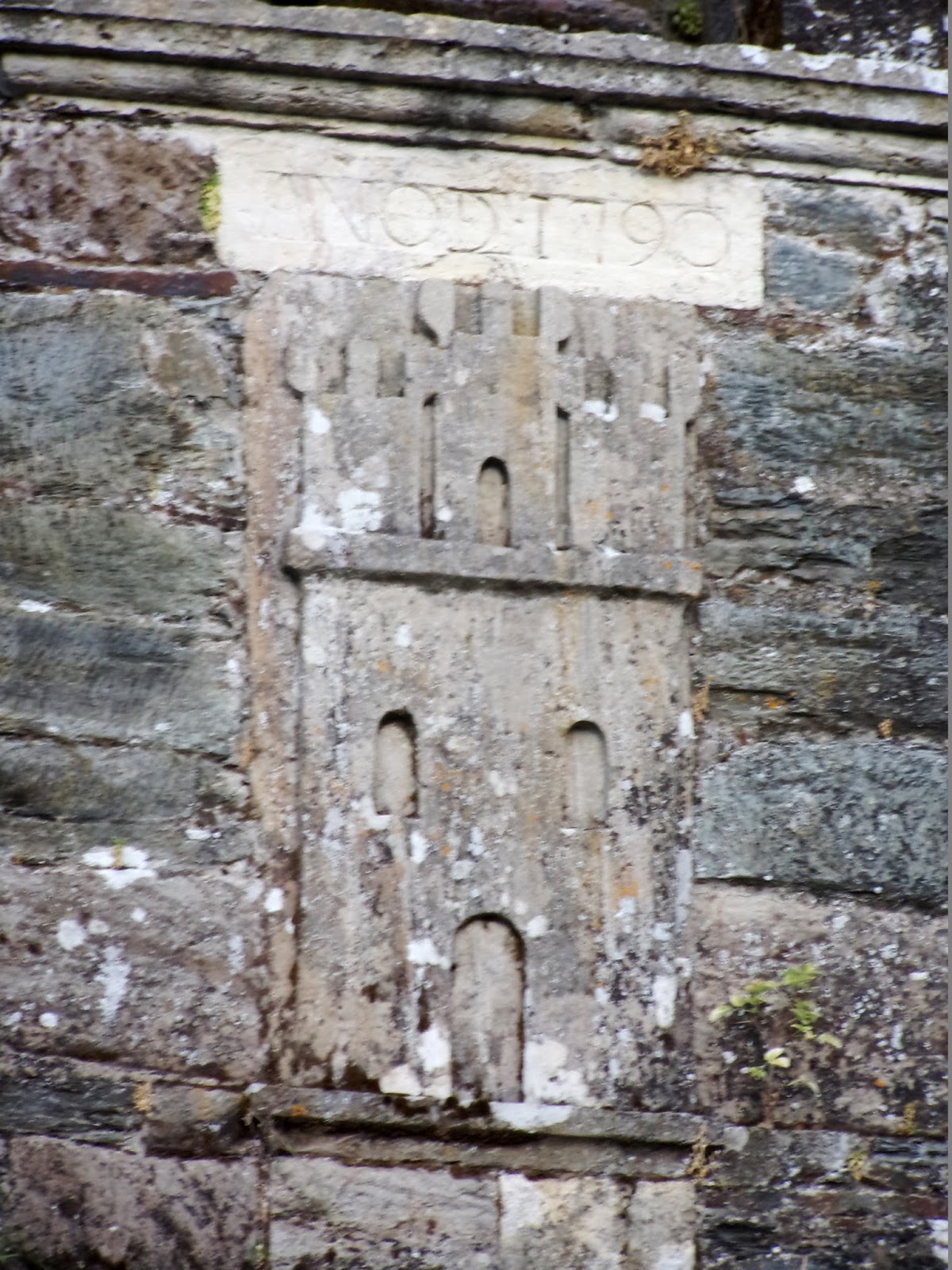
8:00 PM – Triacastela: Iglesia de Santiago – 3 castles relief on bell tower, with inscription “Año DC 1790” [1790 AD] above it.

8:00 PM – Triacastela: Iglesia de Santiago – statue of Santiago in niche on tower, above the castles.
No comments:
Post a Comment