
7:32 AM – Urbanización Camino de Santiago – sunrise from our room.

8:04 AM – Urbanización Camino de Santiago – sunrise from our room, with sun peeking over horizon.
We ate breakfast (included) at Avenida II bar: 2 tostadas con tomate (puree but raw) y aciete; 2 orange juice; MT coffee/Don hot chocolate. We departed Urbanización Santiago de Compostela at 8:30 am and passed through Villadangos del Páramo (pop 400 in town, municipality 1,100) around 8:50.

8:50 AM – Villadangos del Páramo: Yellow arrow and 298 km to Santiago.
Villadangos del Páramo is located in the flat Páramo Leonés. The town was repopulated during the initial stage of the Reconquista. In the year 1111, a bloody battle took place here between the
supporters of the Queen Urraca of León and her son Alfonso VII, who had been crowned King of Galicia and would be crowned King of León, and those of Urraca’s husband Alfonso I the Warrior, King of Aragón, who wanted to direct affairs in León. Although the two monarchs were married to each other at the time, their marriage was eventually annulled and the wars ceased.
El Páramo Leonés [desert; high, barren plain of León], sometimes known as just El Páramo, is a current governmental comarca (region) in the Province of León. It is also a traditional and geographic region primarily in modern León, although a few km on the south goes into the neighboring Province of Zamora. The region has well-defined boundaries between the valleys of the rivers Esla (on the east [which flows through Mansilla de las Mulas]) and Órbigo (on the west [which flows through Hospital de Órbigo]), from the foothills of the Cordillera Cantábrica mountain range in the north to the confluence of the above-mentioned rivers near Benavente. Its topography is one of the flattest of all the Iberian Peninsula. It is classified as an interfluvial páramo (wasteland between rivers), the largest found in León and one of the largest in the Iberian Peninsula. Therefore, it is a plateau about 50 km from north to south and about 30 km from east to west. No major rivers flow through the Páramo; so, much of the territory is intensively irrigated with water from the Barrios de Luna reservoir and the rivers Esla and Órbigo. Traditional popular architecture is primarily build of adobe (unfired bricks), which differs from that in other regions by adding straw to the mud. Straw was also used for roofs until the introduction of tile. Wood was used only for door and window frames and the beams that supported the roof or upper story floor.
The first recorded use of the term páramo was on a Roman tombstone, but is thought to be a pre-Roman word that was later adopted into Latin. Despite the dryness of the land, the area is thought to have been inhabited in pre-Roman times, probably by Astur tribes. In 458, armies of Swabians and Visigoths clashed in the Páramo (desert) near the river Órbigo. During the Arab invasion, some of the people took refuge in the mountains, but the preservation of the name Páramo and the abundance of place names and monasteries in documents of the 10th century indicate that a stronghold of population remained there between the Moorish invasion and the repopulation. Mozarabic influences also indicate that Christians migrated here from Moorish-held lands in the 10th century. In the 11th and 12th centuries, there was an increase of documents referring to the Páramo, highlighting battles and foundation of monasteries. In the 13th to 15th centuries, the Quiñones family would play an important role in the Páramo. As in many rural areas, many towns in the Páramo have disappeared over the years in modern times.
We walked rapidly (Don set the pace) on level, fine gravel roads (sendas) next to highway. Shortly after 9 am, we saw what we initially thought was a hang glider (paraglider) about to land in a cornfield. As it got nearer, we realized that it was motorized and that the pilot was merely circling around over the field.

9:04 AM – Between Villadangos del Páramo and San Martín del Camino: MT on senda path between N-120 highway and cornfield with paraglider approaching (not yet knowing it was motorized, we thought he was about to land).

9:05 AM – Between Villadangos del Páramo and San Martín del Camino: Motorized paraglider maneuvering over cornfield.

9:05 AM – Between Villadangos del Páramo and San Martín del Camino: Motorized paraglider (telephoto, 156 mm).

9:15 AM – Between Villadangos del Páramo and San Martín del Camino: senda along highway N-120 by (green) cornfield.
We passed through San Martín del Camino (pop 509) around 9:45.
The village of San Martín del Camino dates from at least the early 13th century. A hospice is documented on its Calle Real from the 17th through 19th centuries.
We got sellos at Albergue Santa Ana.

9:47 AM – San Martín del Camino: Albergue Santa Ana, with our walking poles at left.
This area used to by dry, wheat-farming country. In recent years, however, wells were dug to tap underground aquifers, and a network of canals has brought abundant water to the flatlands bordering the Río Órbigo. This has permitted some diversification of crops, such as potatoes, corn, and sugar beets.
We arrived in Puente del Órbigo (pop 218) around 11:20.

11:15 AM – Puente de Órbigo: MT on path by haystack and modern water tower on outskirts of town.
Puente del Órbigo is a town within the municipality (localidad) of Hospital de Órbigo. In ancient times, this ford over the Río Órbigo was a strategic transportation node, leading the Romans to establish a settlement here. Later, it was the site of many battles. In 452, the Visigoths defeated the Swabians, in 878, King Alfonso III of Asturias defeated Muslim armies in the Battle of Polvoraria (or Polvoroso) near the Río Órbigo; and in the 12th century King Alfonso VII of León reconquered this place from the Moors. In the Middle Ages, there was a small village on the east bank of the Río Órbigo that had formed around the church of Santa María. It was called Puente de Órbigo. The bridge has facilitated trade since Roman times, including the passage of livestock as part of the cattle trail (Camino de la Cañada Real de la Plata) and later the passage of pilgrims.
The bridge Puente de Órbigo (aka Puente del Passo Honroso) is the longest on the Camino (204 m/approx. 670 ft) and is one of the longest and best preserved medieval bridges in Spain, dating from the 13th century and built over an earlier Roman bridge which sat on the old Roman road from León to Astorga (Asturica), part of the Vía Aquitania, which connected the silver mines of El Bierzo with France. Possibly, there was an even earlier bridge that was remodeled by Roman engineers. At the turn of the first millennium, it became integrated into the Camino Francés route to Santiago de Compostela. It formed one of the great historical landmarks on the Camino. The bridge seems too large for the river, but before the construction of the Barrios de Luna reservoir, the river was much wider. Floods have swept away one or more of the bridge’s arches at least five times since the 13th century. Numbered from east to west, arches 3-6 are 13th century, arches 7-16 are 17th century, and arches 1-2 and 17-19 are 19th century (replacing arches on both ends of the bridge that were blown up by Spain’s British allies in 1809, during the Spanish War of Independence, when they were forced to retreat into Galicia and wanted to keep Napoleon’s army from pursuing them. The reconstructions have maintained the medieval Gothic style.
The 19 arches carry you across the Río Órbigo via the Passo Honroso, so called because of the famous jousting tournament that took place here in the Jacobean Holy Year 1434. A noble knight from León, Don Suero de Quiñones (1409-1456 or 1458), of an illustrious family of the Páramo region, was scorned by a beautiful lady, Doña Leonor de Tovar, and made a pledge under which he would have to fast every Thursday and wear a heavy iron ring around his neck as a symbol of being enslaved by his love for her. Then he obtained the permission of King Juan II of Castile (who was then at the Castillo de la Mota in Medina del Campo with his family) to conduct a special tournament in which he would engage all men who passed over the Puente de Órbigo. (Only unarmed pilgrims were allowed to cross.) He threw down the gauntlet to any knight who dared to pass as he undertook to defend the bridge (and presumably his honor) against all comers. If they refused to participate, they had to deposit a glove as a signal of cowardice and cross the river by fording. The king invited the best knights of the realm to take the path to Hospital de Órbigo. Those attempting to pass the bridge would engage in single combat with Don Suero or one of his 9 companions until 3 lances were broken; this would continue until a total of 300 lances were broken. The tournament began on July 10. Sixty-eight knights from all over Europe (France, Germany, Portugal, and Spain, especially the Kingdom of Aragón) took up the challenge, making 727 runs of the gauntlet. Don Suero successfully defended the bridge for the month of July (except for a break on the Feast of Santiago in July 25). He was supposed to continue until 300 lances had been broken, but after Don Suero was wounded on August 9, the judges of the contest decided that the 166 broken lances were sufficient to free Don Suero from his pledge. (According to the extensive rules of the tournament, a knight wounded in the joust could not continue to compete, although Don Suero and his companions had been allowed to circumvent this rule. Besides that, the judges had already decided that breaking 300 lances was an exaggerated goal.) For this reason, the bridge is known as Passo Honroso (Honorable Crossing or Passage of Honor). Together with his 9 trusted comrades (mantenedores), Don Suero then proceeded to Santiago to offer thanks for his freedom from the bonds of love and for his honor, now restored. A month later, Don Suero married Doña Leonor.
The story of el Passo Honroso is mentioned in Cervantes’ Don Quixote (1605), and the chivalrous acts of Don Suero may have been an inspiration for Don Quixote. Nowadays, every year on the first weekend of June, the tournament is re-enacted during the Fiesta de las Justas del Passo Honroso on a field close to the bridge, with combat, a grand dinner, a market, and mass in Latin.

11:24 AM – Puente de Órbigo: medieval bridge; in field at far end on the left are jousting rails (for re-enactment); beyond the bridge is the town of Hospital de Órbigo with Iglesia de San Juan Bautista.

11:25 AM – Puente de Órbigo: surface of bridge with flagstone strip down middle (better view of jousting rails).

11:29 AM – Puente de Órbigo: sign for “La Puente del Passo Honroso”; Spanish text [translated:
Centuries of history
Declared a National Monument in 1939 and a Bien de Interés Cultural, the serpentine bridge guaranteed the crossing of the river Órbigo. Its stones have a long history dating back to the times in which Rome occupied these and other lands of Iberia.
[Since this was a] strategic enclave at the foot of the Cordillera Cantábrica {mountains}, since time immemorial, trashumantes [migrating for seasonal grazing] cattle came here seeking summer pastures in the mountains. Possibly they forded the river at this point, and later a bridge would be built here that would be used, remodeled, and expanded by Roman engineers, being incorporated into the Vía Aquitania which, between Asturica {Astorga} and Tarraco {Tarragona in Catalonia, Spain}, saw much of the gold and other precious metals exploited in mines all over the northwest of the Iberian Peninsula.
The 5th century again brought struggles to the banks of the Órbigo, which in October 456 witnessed the bloody confrontation between the Swabian Requiario and Theodoric, King of the Visigoths. When the Swabian was defeated in the Battle of Urbico, his kingdom was relegated to the confines of Galicia.
Established as road infrastructure, the bridge was rebuilt during the Middle Ages. The strong offensive initiated by his predecessors and led by Alfonso III pushed the Saracens to the Duero, by which these lands were repopulated little by little. Not being therefore exempt from continuous incursions from Córdoba.
At the turn of the first millennium, the Camino Francés was established as the route to Compostela; the bridge was integrated into the Jacobean route, and its role was reinforced by the foundation, just on the other side, of a hospital run by the Knights Hospitallers of the Order of St. John of Jerusalem. Its life continues today thanks to the numerous pilgrims who pass through every year on the Camino de Santiago, declared a World Heritage in 1993.
The bridge has known other battles; it did not come off well against some of them, such as during the War of Independence {1808-1814}, when the British blew up some of its arches in order to prevent the advance of French troops.
Its imposing appearance today is, above all, due to thorough remodeling practiced in 1946, together with other interventions that have happened since then.
The Bridge at a glance
Of Roman origin and medieval manufacture, ashlars and masonry form a solid structure for which the arches and vaults reveal the successive periods of construction. Restored and remodeled on numerous occasions throughout its history, the last of these interventions date back to the 1980s. But perhaps the inauguration of the arches 17, 18, and 19, back in the 1950s, was one that raised the most expectations, bringing together a multitude of the public on the banks of the river and with the presence of the Banner of Clavijo, safeguarded in Astorga, which scarcely leaves its headquarters once a year.
El Passo Honroso
One historical episode is linked to the Puente el Órbigo above all others. It was in the month of January of the Jacobean Holy Year 1434; Don Suero, son of Don Diego de Quiñones, a knight of King Juan II and poet of the court, asked his lord’s consent to hold a tournament. The rules of the Passo Honroso were signed in Medina del Campo.
In love with Doña Leonor de Tovar, Don Suero was punished for his love with fasting and bearing every Thursday a heavy ring around his neck. To win the admiration of the lady and accompanied by his 9 maintainers, he challenged all knights who dared come to fight on the site of the Puente de Órbigo, promising to break up to 300 lances.
For the month of July, the liza [lists in English are a high fence of stakes enclosing the area in which a tournament was held], the scaffolds and grandstands stood at the foot of the bridge, from where the people could witness the combat, and 22 shops willing to accommodate the inflow of ladies, gentlemen, armorers, trumpeters, doctors, and chaplains, during the 30 days that the jousts lasted.
Only interrupted to celebrate the feast day of the patron Santiago, nobility, judges, clerks and notaries, such as Rodríguez de Lena, who recorded the event in the “Libro del famoso Passo Honroso,” attended these jousts, dangerous as few to be held, as is recorded in the rules, without shields. More than 60 knights from France, Germany, Portugal, and Spain broke their lances in 727 passes. If, when the moment arrived, one who decided not to be measured in the joust had to cross the river by the riverbed, bearing the reputation of a coward. The only ones exempt from fighting were pilgrims who could attest to their status with a letter from their parish priest.
166 lances that broke were enough to free Don Suero. After the feat and a deserved rest in his castle at Laguna de Negrillos, he made a pilgrimage with his knights to kneel before the tomb of the Apostle Santiago, to whom he offered a replica in gold of the ring with the inscription
“SI A VOUS NE PLSYST AVOYR MESURA,
CERTES IE SUY SANS VENTURA.”
“That lady will belong to me, if you do not moderate your vigor.” {A better translation of the French is” “If you do not reciprocate in kind, in truth there is not joy for me.”}
That still shines around the neck of the bust of Santiago el Menor {St. James the Lesser}, guarded in the chapel of relics in Compostela’s cathedral.
A year later, Don Suero married Doña Leonor; twenty-four years later, one of the knights defeated in the jousting would end the life of {Don} Suero de Quiñones.
At the present time, each month of June, the liza {lists}, scaffolds, and shops again bring color to the Puente de Órbigo, to commemorate those jousts that occurred so long ago with simulated combat, a great dinner, Mass in Latin, and market.]
The callouts for the photo of the bridge at the bottom identify (from right to left) arches 1 and 2 on the end by the village of Puente de Órbigo, below which it says that during the War of Independence the British forces when retreating to Galicia, blew up part of the bridge; arches 3-8 as “Tramo medieval posterior S. XIII” [late medieval span 13th century]; arches 9-13 as “Tramo medieval con arcos de cañon, Probablemente se remonta a los S. X y XI” [medieval span with arches of barrel, probably were repaired in the 10th and 11th centuries]; arches 14-16 as “Tramo renacimiento s. XVII” [Renaissance span, 17th century]’ arches 17-19 (on end of Hospital de Órbigo), which text above says were inaugurated in 1950s, marking the last (19th) arch as having the Canal de la Barbacana [canal of the barbican] located below that arch.

11:31 AM – Puente de Órbigo: looking back across the bridge to town of Puente de Órbigo; good view of jousting rails at right (S) of bridge.

11:31 AM – Puente de Órbigo: view back across bridge to Ermita de Nuestra Señora de la Purificación in town of Puente de Órbigo, with stork nests on belfry and roof (telephoto, 156 mm).
The 17th-century Ermita de Nuestra Señora de la Purificación (aka Iglesia de Nuestra Señora de la Purificación) [erroneously identified in Brierley as Iglesia de Santa María] at the east end of the bridge is capped by four large storks’ nests (three on the belfry and one on the roof over the apse). The marshy riverbanks offer the storks enough food that they can stay here year-round.

11:31 AM – Puente de Órbigo: looking back across the bridge to town of Puente de Órbigo, with clearer view of jousting rails on field S of bridge.

11:31 AM – Puente de Órbigo: Don on bridge with town of Puente de Órbigo in background.
We arrived in Hospital del Órbigo (pop 1,195) around 11:30.
In the late 16th century, another village was organized by the ancient pilgrims, on the west bank of the Río Órbigo. A pilgrim hospital was founded there by the Caballeros Hospitalarios del Orden de San Juan de Jerusalén (Order of Knights of St. John of Jerusalem). The hospital operated until 1850. This town took the name of Hospital de Órbigo. In the 19th century, the British destroyed both ends of the bridge to prevent the passage of Napoleon’s troops. (Other sources say the inhabitants of Hospital de Órbigo did it, for the same reason—which seems less likely.)
Crossing the bridge and continuing to the west, we encountered the Iglesia de San Juan Bautista.

11:44 AM - Hospital de Órbigo: Iglesia de San Juan Bautista – exterior from SW (near construction down the street).
The Iglesia de San Juan Bautista [Church of St. John the Baptist], rebuilt in 17th and 18th centuries in a combination of Baroque and neo-classical style, is what remains of the ancient pilgrim hospital built in the 12th century by the Caballeros de San Juan de Jerusalén (Knights of the Order of St. John of Jerusalem), known as caballeros hospitalarios. In the second half of the 12th century, the church was built for pilgrims and, in 1184, it was ceded to the Orden de San Juan de Jerusalén, who built a pilgrim hospital nearby. The tall tower houses a clock and bell. The church is accessed by a portico with triple arches, with an image of San Juan Bautista in a wooden alcove next to the coat of arms of its founders, the Knights of St. John. Inside is a Plateresque altarpiece.
Somewhere in the town, we got a nice sello with the coat of arms of Hospital de Órbigo displaying a Maltese cross (symbol of the Orden de San Juan de Jerusalén) and a mounted knight armed with a lance (Don Suero) on the bridge.

11:42 AM - Hospital de Órbigo: Iglesia de San Juan Bautista - tower.

11:42 AM - Hospital de Órbigo: Iglesia de San Juan Bautista – entrance exterior.

11:41 AM - Hospital de Órbigo: Iglesia de San Juan Bautista – statue of San Juan Bautista over entry door (exterior).

11:41 AM - Hospital de Órbigo: Iglesia de San Juan Bautista –statue of Christ (near sign about Resurrection) on inside wall opposite the entrance.

11:40 AM - Hospital de Órbigo: Iglesia de San Juan Bautista – view from rear of nave to main altar.
Not finding a good bar for lunch in Hospital de Órbigo, we went on. After Hospital de Órbigo, there was a choice of two routes to Astorga. Since the traditional way was along highway N-120, we chose the alternative route on quiet minor roads and dirt tracks.
The Río Órbigo is the western limit of the desolate Páramo Leónes. Here, we are approaching the extreme northwest corner of the Meseta, with the Montes de León to the west and the Cordillera Cantábrica to the north. From here, one can see the heart of the Ribero del Órbigo, the irrigated valley of the Río Órbigo, with multiple channels and dams. Prior to the Reconquista, there were Roman settlements in the valley. After the Reconquista, local nobles attempted to repopulate the area with Mozárabes (Christians who had kept their religion in Muslim-occupied territories), who may have brought with them the techniques of irrigation.

12:06 PM – After Hospital de Órbigo: green cornfields on both sides of path (Villares de Órbigo beyond tree line in distance).

12:13 PM – After Hospital de Órbigo: path through tree line at end of cornfields.

12:15 PM – After Hospital de Órbigo: MT on path near passage through tree line.
We arrived at Villares de Órbigo (pop 283) around 12:30.
Villares de Órbigo had a pilgrim hospital. The Iglesia de Santiago is a combination of the two most representative styles of Spanish architecture: Romanesque and Baroque. Above the town is an early Iron Age castro called El Santo.
We stopped at Bar Piris for lunch: MT ordered 2 sangrias and 2 tortillas con jamón (ham) which came with bread; 1 bottle of water (total 8€). Then she went to a grocery store and bought samples of 3 cheeses, and also an apple and orange (total 3€+).

12:27 PM – Villares de Órbigo: Bar Piris (we ate at table on left, near our packs).
We departed Villares de Órbigo at 1:05, still on a dirt path. After climbing over a hill, we joined an asphalt road.

1:30 PM – After Villares de Órbigo: clouds over ridge in road.

1:32 PM – After Villares de Órbigo: Don on paved road.
We reached Santibañez de Valdeiglesias (pop 191) around 1:40.

1:43 PM - Santibañez de Valdeiglesias: Don at city limit sign.
Santibañez is the name of numerous places named for the dedication of the local church to St. John. For example, this is true of two other towns of that name farther south in Castilla y León: Santibañez de Valcorba in the Province of Valladolid, has the Iglesia de San Juan Evangelista [Church of St. John the Evangelist], dedicated to the patron saint of the town; Santibañez de Vidriales, near Zamora, has the Iglesia de San Juan Bautista [Church of St. John the Baptist]. (Santibañez de Valdeiglesias seems to break this pattern, with its church named Iglesia de la Trinidad.) Valdeiglesias means valley of churches and seems to be the name of a nearby valley.
According to some sources, this is where we entered the Maragatería, the land of the Maragatos (see more at Astorga and Rabanal del Camino). Just past Santibañez are the first of many chestnut trees that will be common all the way into Galicia.

1:39 PM - Santibañez de Valdeiglesias: city limit sign and road entering town, with belfry of Iglesia de la Trinidad in background.

1:40 PM - Santibañez de Valdeiglesias: back side of belfry of Iglesia de la Trinidad, with “porch”; the cylindrical brick structure on the right side of the belfry is probably a spiral staircase to the “porch” (telephoto, 360 mm).
The name of Iglesia de la Trinidad suggests that the Trinitarian monks were active here in the 13th century. The church, like several others we would see later, has a belfry or bell gable with a “porch” on the back side, which may have served as a lookout point. (See earlier note at Valverde de la Virgen.)

1:49 PM - Santibañez de Valdeiglesias: front side of Iglesia de la Trinidad, with older-looking stone façade below belfry, both much older than the rest of the building.
Leaving Santibañez de Valdeiglesias, the pavement ended, and the road appeared to continue through a farmyard with barn and cattle pens and up a hill on a rocky road. We started to go back into town to see if we had missed a marked turn, when Don finally saw a small yellow arrow on a utility pole at the far end of the farmyard. Also, a small group of farmers there didn’t say anything, apparently used to pilgrims passing through. So we continued through the farm, sometimes on a path with streams of liquid from the cattle pens.

2:04 PM – After Santibañez de Valdeiglesias: rocky road past farm (yellow arrow painted on a small round stone).

2:04 PM (Cropped) – After Santibañez de Valdeiglesias: yellow arrow painted on a small round stone on rocky road (close-up).

2:05 PM – After Santibañez de Valdeiglesias: Don pointing to small stone with yellow arrow (very hard to see).

2:05 PM – After Santibañez de Valdeiglesias: Don pointing to small stone with yellow arrow (see red circle).

2:12 PM – Near Crucero de San Toribio: approaching roadside “shrine.”

2:12 PM – Near Crucero de San Toribio: roadside “shrine” with cross, bench, and pilgrim effigy.

2:13 PM – Near Crucero de San Toribio: MT on bench in shade by roadside “shrine” (note yellow arrows painted on rock below cross).

2:19 PM – Near Crucero de San Toribio: close-up of yellow arrows painted on another rock (or piece of concrete) by cross of roadside “shrine”; Padeliana is a family name.
From there, a rocky path again led uphill, mostly through a wooded area, where the climb was complicated by endless swarms of flies. Don’s solution was to use one walking pole like a windshield wiper to clear the way ahead.

3:12 PM – Near Crucero de San Toribio: more rocky road with mountains (Montes de León) in distance.
At the end of that section, we came to a roadside refreshment stand with drinks, fruit, nuts, olives, dried apricots, etc., operated by the Associación La Casa de los Dioses. It was run by a pleasant young man named David, who said he had been there for 5 years. We filled our water bottles and got bananas, an apple, and almonds for Don. MT put 1€ in the donation box.

3:13 PM Near Crucero de San Toribio: sign for “Associación La Casa de los Dioses”: free stamp (sello) for donativo (donativo).

3:17 PM - Near Crucero de San Toribio: refreshment stand and David at right (MT at far left). The sign on the stand says: “La llave de la esencia es la presencia” [The key to the essence is the presence].
Shortly after that, we met 3 young German men, on break from their university, that we had seen back in Villares de Órbigo and stayed with them until the Crucero del San Toribio, where we arrived around 3:40.

3:42 PM – Crucero de San Toribio: crucero with town of San Justo de la Vega downhill nearby and Astorga (with twin church towers) and Montes de León in distance.
The stone cross Crucero del San Toribio commemorates the 5th-century Bishop Toribio of Astorga, who supposedly fell to his knees here in a final farewell, having been banished from the town. From here, there is a wonderful view of the town of San Justo de la Vega (before the tree line) and the city of Astorga with its twin cathedral towers, farther in the distance. Visible beyond Astorga are the Montes de León, which we would cross in the days ahead through the highest part of the whole Camino at 1,515 m (4,970 ft). Over to the left (southwest) is El Teleno, a mountain sacred to the Roman god Mars at 2,185 m (7,170 ft), while due north [not in the photo] stands Peña Ubiña at 2,417 m (7,930 ft), marking the southern flank of the Cordillera Cantábrica range that stretches along the coast of the Cantabrian Sea across northern Spain from the western limit of the Pyrenees to Galicia. Just below the cross is a viewpoint with orientation map and a splendid view of Astorga in the valley below. From here, the path drops steeply to pick up the asphalt road into San Justo de la Vega.

3:43 PM – Crucero de San Toribio: MT and German pilgrims on path downhill toward town of San Justo de la Vega nearby and Astorga (with twin church towers) and Montes de León in distance.

3:45 PM – Crucero de San Toribio: orientation map at viewpoint (with circles around San Justo de la Vega and Astorga).

3:46 PM – Crucero de San Toribio: close-up of orientation map at viewpoint (close-up focusing on circles around [most of] San Justo de la Vega in foreground and Astorga in distance, beyond tree line).

3:45 PM – Crucero de San Toribio: view from orientation map at viewpoint down paved path toward San Justo de la Vega.
We passed through San Justo de la Vega (pop 2,365) around 3:55-4:10 pm on the way into Astorga.
Records indicate that San Justo de la Vega had a pilgrim hospice in the Middle ages, but there is no trace of it now.
The brothers Saint Justus (Justo) and Saint Pastor are venerated as Christian martyrs. They were two schoolboys (Justus was 7 [or 13], Pastor was 9 [or less than 9]) who were killed for their faith in 304 during the persecution of Christians by the Roman Emperor Diocletian. When they refused to denounce Christianity, they were flogged and beheaded outside the city of Alcalá de Henares, near Madrid. According to tradition, they were children of San Vidal and nephews of Santa Marta de Astorga.

3:55 PM - San Justo de la Vega: statue of pilgrim drinking water.
The bronze statue “‘Sitio’ (Tengo Sed)” [“Site’ I Am Thirsty] is by the Maragato painter and sculptor Rosendo Garcia Ramos (known as “Sendo”), a native of San Justo de la Vega. Inaugurated on August 2, 2014, this work is his second in recognition of pilgrims on the Camino de Santiago (the other is in front of the Albergue de las Siervas de María in Astorga). When you push the button on the top of the hydrant, water flows from the pilgrim’s gourd.

3:54 PM - San Justo de la Vega: Don drinking water with the pilgrim statue.

3:55 PM - San Justo de la Vega: MT drinking water with the pilgrim statue.

3:56 PM - San Justo de la Vega: plaque by pilgrim statue: “‘SITIO’ (Tengo Sed)” [“Site” I’m Thirsty], listing the Autor [sculptor] as Sendo.

4:11 PM - San Justo de la Vega: modern church Iglesia de San Justo de la Vega with old facade and belfry with “porch” (in this case, the old west façade is still on the west end of the church).
The 16th-century Iglesia de San Justo de la Vega (aka Iglesia de San Justo de la Vega y Pastor [churches of this name are usually dedicated to San Justo and San Pastor, since the brothers were martyred together]) was torn down in the 1980s because it was in ruins; only the west wall with the belfry was preserved when the new church was built. It still has a 17th-century altarpiece.
We arrived in Astorga (pop 12,564) around 4:45.

4:45 PM – Astorga – cathedral from distance, from top of footbridge over railway; visible this side of cathedral is the turret of the 19th-century Casa Granell (telephoto, 220 mm).
Astorga sits on a steep ridge with an array of historical buildings tightly packed within its medieval (and Roman) walls. Before the Romans arrived, Astorga was home to the Celtic Astur tribe. In the Cantabrian Wars (28-19 BC), the Romans finally eliminated the Celtic resistance. The region was then conquered by the Roman legion Legio X Gemina, which settled on a hill where the center of the city is today. In 14 BC, the Romans founded the town they named Asturica Augusta there. It became an important Roman fortified city due to its prominent position at the junction of several major routes and the presence of many gold mines in the area. Asturica was the main city in northwest Spain during the Roman Empire. Because the Romans controlled the city, Christianity became very popular in the area. One of the first three bishoprics in Spain was founded in Astorga in the 3rd century. The city walls were built in the 4th century AD,
In 456, Astorga was sacked by the Visigoths. During the Moorish invasion, the city was abandoned, serving as a largely empty buffer zone between Moors and Christians, until its repopulation in the 9th century. However, its true revival came in the 11th century, when the city became a major stop on the Camino Francés. Astorga was a place for pilgrims to rest and get ready to climb the mountains to the west.
This is where the Camino Francés (part of the Vía Trajana linking this area with Bordeaux) and the Roman Road Calzada Romana (aka Vía Aquitania) joined the Roman Silver Route (Vía de la Plata, aka Camino Mozarabe) from Sevilla and the south. (The Vía de la Plata is usually referred to as the Silver Route, although some scholars suggest that “plata” is a corruption of the Arabic word for wide, not silver; however, the mountains to the west do produce gold, silver, and other valuable ores.) This convergence of routes gave rise to 22 pilgrim hospitals during the height of the Camino de Santiago in the Middle Ages. Astorga also acted as a crossroads for the royal drove roads (Cañadas Reales) that herded livestock up and down the Iberian peninsula, as part of a European-wide system of nomadic grazing known as transhumance (trashumancia in Spanish).
Here we entered the Montes de León and the Maragatería (aka Pais de los Maragatos; Tierra de Maragatos in the Leonese language, which is widely spoken in this region). Between Astorga and Molinaseca, we experienced the remnants of Maragato culture in the distinctive native dress and cuisine of this mountainous region. The men wore wide bloomer pants, a large belt, white shirts, red garters, and a large slouch hat; women wore crescent hats, lacy mantels, heavy black skirts, and intricate filigree earrings. Cocido Maragato (Cocíu maragatu in Leonese language) is a traditional local meat dish (plentiful and varied) followed by soup. The pastries mantecadas are worth sampling. The origins of the name Maragato are obscure. Initially, it was thought to be derived from the Latin capti Mauri (captured Moors), referring to a supposed Berber origin. According to other traditions, the Maragatos may date back to the 7th century, when King Mauregato and his followers became isolated in this remote area during the Arab invasions. (Today, the isolation continues in the abandoned villages of the mountains, such as Foncebadón.) .Mauregato was also the name of a famous King of Asturias (d. 789), since he may have been the son of a female Moorish captive. Another explanation is that Moors who invaded Spain intermarried with Goths (Gotos), giving birth to children who were neither Moors nor Goths, but “maurogotos” (Maragatos). Some suggest they are descended the Phoenicians or from the Berber tribes who came to Spain as part of the Moorish invation in the 8th century, becoming “misplaced” in this remote mountainous region. Most agree they were muleteers, and their number has dwindled to 4,000 spread around 45 villages in the area.
Here we entered the Montes de León and the Maragatería (aka Pais de los Maragatos; Tierra de Maragatos in the Leonese language, which is widely spoken in this region). Between Astorga and Molinaseca, we experienced the remnants of Maragato culture in the distinctive native dress and cuisine of this mountainous region. The men wore wide bloomer pants, a large belt, white shirts, red garters, and a large slouch hat; women wore crescent hats, lacy mantels, heavy black skirts, and intricate filigree earrings. Cocido Maragato (Cocíu maragatu in Leonese language) is a traditional local meat dish (plentiful and varied) followed by soup. The pastries mantecadas are worth sampling. The origins of the name Maragato are obscure. Initially, it was thought to be derived from the Latin capti Mauri (captured Moors), referring to a supposed Berber origin. According to other traditions, the Maragatos may date back to the 7th century, when King Mauregato and his followers became isolated in this remote area during the Arab invasions. (Today, the isolation continues in the abandoned villages of the mountains, such as Foncebadón.) .Mauregato was also the name of a famous King of Asturias (d. 789), since he may have been the son of a female Moorish captive. Another explanation is that Moors who invaded Spain intermarried with Goths (Gotos), giving birth to children who were neither Moors nor Goths, but “maurogotos” (Maragatos). Some suggest they are descended the Phoenicians or from the Berber tribes who came to Spain as part of the Moorish invation in the 8th century, becoming “misplaced” in this remote mountainous region. Most agree they were muleteers, and their number has dwindled to 4,000 spread around 45 villages in the area.
We entered Astorga by means of a large pasarela (footbridge) over railroad tracks.

4:46 PM – Astorga – pasarela (footbridge) over railroad tracks (view back to E).

4:46 PM – Astorga – MT on footbridge over railroad tracks (view to N).

5:01 PM – Astorga – Don at Camino sign entering Astorga.
We entered the old city through the southern entrance Puerta Sol of the city wall and soon came to Plaza San Francisco with the 13th-century Convento de San Francisco.

Thursday, September 11, 2014, 3:46 PM – Astorga: Convento de San Francisco, with Capilla de la Santa Cruz attached at right and pilgrim statue at right.
The Convento de San Francisco [Convent of St. Francis] is said to have been founded by St. Francis of Assisi (1182-1226). St. Francis allegedly came here on his pilgrimage to Santiago in 1212 [the city of Santiago dates his visit in 1214]. According to legend, St. Francis stayed overnight in Astorga without being recognized by anyone except the Bishop, who offered to establish a convent, said to have been founded during his visit (although the church was built in 1272). The original 13th-century church was replaced by the current one in the 17th century, partially preserving the Gothic original—only a chapel and window. In the early 19th century, it was practically destroyed by French troops, then rebuilt by the Franciscan community that resided here until the confiscation of Mendizábal in 1835. In 1883, the Bishop of Astorga offered it to Redemptorist missionaries, who restored it.
Attached to the wall of this church is the small chapel of Santa Vera Cruz, built in the early 19th century, which is the headquarters for the Confraternity of the True Cross. Today it is a nursing home for elderly Redemptorists, a college-seminary, and a museum.
In the Plaza de San Francisco was a bronze statue of a pilgrim.

5:04 PM – Astorga – Pilgrim statue near Convento de San Francisco; plaque says “Quo Vadis ‘El Caminante’ … Sendo 2011.”
The bronze statue, “Quo Vadis ‘El Caminante’” [Quo Vadis: The Walker] was installed in the Plaza de San Francisco in 2011. It is by the Maragato painter and sculptor Rosendo Garcia Ramos (known as “Sendo”), a native of San Justo de la Vega, and is linked to the Camino de Santiago. It is directly in front of the Albergue de las Siervas de María near the Puerta Sol. The bronze statue “Sitio (Tengo Sed)” in San Justa de la Vega is also the work of “Sendo.”
Continuing on the Camino route through the city, we came to Plaza Bartolomé on which Iglesia de San Bartolomé is located. We stopped there briefly for MT to check the Hotel Via de la Plata Spa (4-star sister of Hotel Astvr Plaza Spa); they only had single rooms left, for 60€. On the same Plaza Bartolomé, MT tried Hostal La Peseta, where a double room was 60.50€. On this square was also a restaurant where we saw the first sign for Cocido Maragato, which we wanted to try later.

5:07 PM – Astorga – Iglesia de San Bartolomé on Plaza Bartolomé.
Iglesia de San Bartolomé is the oldest church of the city, built at the end of the 11th century in the Romanesque style. Later interventions have resulted in an amalgam of styles from different epochs. There are remnants of the primitive construction of Mozarbic, Romanesque, Gothic, Baroque, and other interventions. The tower dates from the 12th century (although its top was later), the portal and rose window above it from the 14th, and the transept from the 16th. The successive reforms have given the façade the sensation of breaking the symmetry. The church originally had only a single nave with the tower on its south (right), but two more naves were added later. The ogival portal represents the Astorgan Gothic. The main altarpiece is Churrigueresque (Spanish Baroque).
Not pleased with those hotels, we went on to the Plaza Mayor to check on Hotel Astvr Plaza Spa (3-star). We told the receptionist Ana we had stayed there June 25, 2013 with a special pilgrim rate. She found that in her computer and said we could have that again, but it had gone up from 65 to 70€ including breakfast (she had just given somebody a room for 100€). We got sellos there. We got Ana to call Silvia at Arcos Peluqueria (where we both got haircuts last year), and Silvia said she could cut Don’s hair at 7:30 pm that day and cut and color MT’s at 11:45 am Thursday, since that would take longer.
Right next to Hotel Astvr Plaza Spa on Plaza Mayor was the Ayuntamiento (City Hall) of Astorga.
The Ayuntamiento (City Hall, aka Casa Consistorial) was begun in 1675 in Herrerian style, similar to that of the Cathedral, with spires and towers of Flemish influence. The building was completed in the 18th century, enlarged in the 19th century, and renovated in 1994. It is one of the most visited sites in the city thanks to the Maragato bell ringers on the city clock..

Thursday, September 11, 2014, 12:22 PM – Astorga: Plaza Mayor with Ayuntamiento (City Hall), Hotel Astvr Plaza, and restaurants.
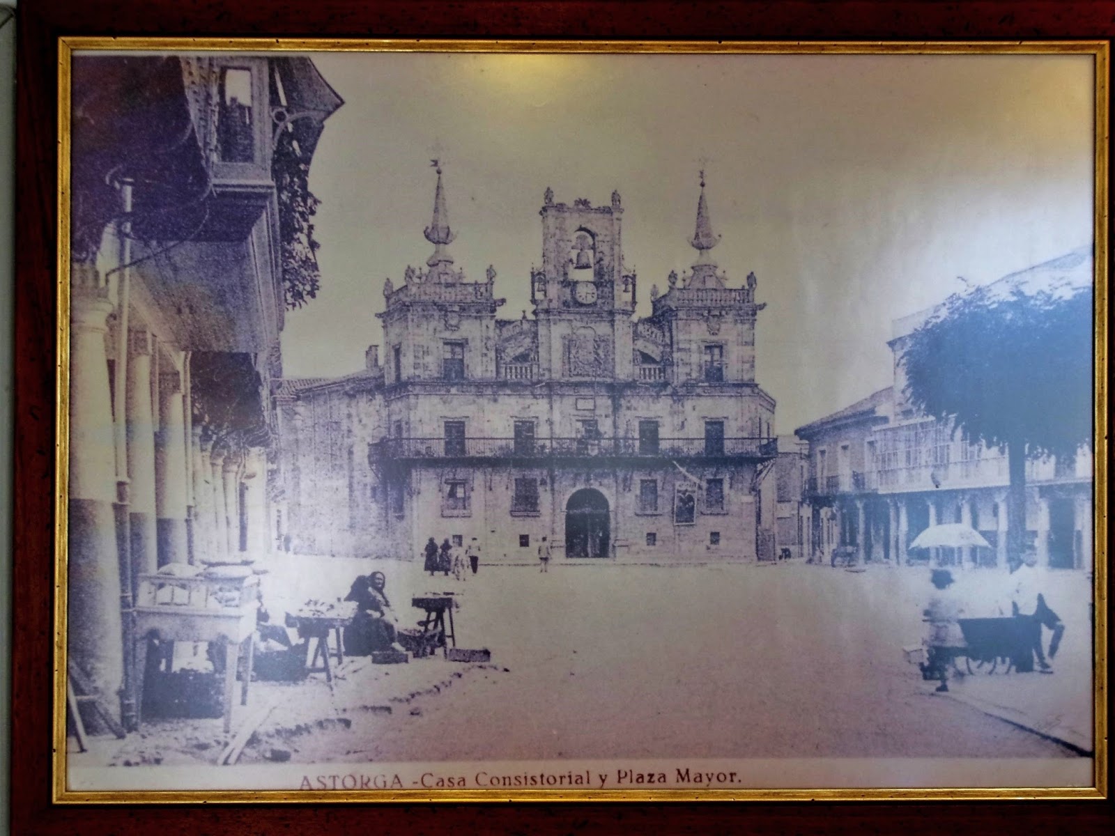
Thursday, September 11, 2014, 1104 AM – Astorga: old photo of “ASTORGA – Casa Consitorial y Plaza Mayor” from early 20th century, in pastelería (pastry shop) where we bought little cakes and chocolates as hostess gift for Silvia. Sometime during the day (Sep 11), we got sellos at “La Tienda del Peregrino”; this may have been it.

Thursday, September 11, 2014, 430 PM (cropped) – Astorga: old photo of Plaza Mayor and City Hall (Ayuntamiento or Casa Consistorial) from brochure in our hotel lobby for “Cuidad de Astorga” film festival.

5:29 PM – Astorga: Hotel Astvr Plaza – MT in our room, No. 106.

5:29 PM – Astorga: Hotel Astvr Plaza – our room, No. 106.

Thursday, September 11, 2014, 12:31 PM – Astorga: notice on our bathroom mirror about hanging laundry: “Due to being in the city’s main square, our authorities do not allow to hang any clothes to dry in our balconies.”

6:06 PM – Astorga – view of Plaza Mayor from our hotel room.

Thursday, September 11, 2014, 12:38 PM - Astorga – Cervesería Asador restaurant in Hotel Astvr Plaza building – 9€ pilgrim menu posted in window.
We followed the Camino arrows to find Acros Peluqueria (at the northwest edge of the old city), since that was how we found it last year on our way out of town. During Don’s haircut, Silvia’s husband and young son and daughter came to the shop, since this was her last appointment of the day.

Thursday, September 11, 2014, 12:57 PM – Astorga: Arcos Peluqueria exterior.

7:51 PM – Astorga – Silvia preparing to cut Don’s hair.

7:55 PM – Astorga – Silvia’s husband arriving during haircut.

7:58 PM – Astorga – Silvia cutting Don’s hair.

8:11 PM – Astorga – MT, Silvia, and Don after haircut. She said she used no. 4 clipper on sides and No. 2 on top.
We went back to Plaza Mayor and ate the 9€ pilgrim menu, outside, at the restaurant Cerveseria Asador in the same building as Hotel Astvr Plaza: 1st course: both had pasta a la boloñese; 2nd course: MT carrillera [literally jaw; chin strap] quisada con guarnición (stewed beef with garnish) served with patatas fritas/Don lomo de cerdo con patatas fritas o ensalada (pork loin with French fries or salad [Don chose salad]); dessert: both had cheesecake; bottle of red wine; bottle of water; bread.

8:38 PM – Astorga – Cerveseria Asador restaurant 9€ pilgrim’s menu.
Just as we were about to order dinner, Don noticed a Farmácia (pharmacy) across the square was still open; so, as soon as we ordered, he ran there and got 30 packets of Metamucil for 8.26€ (the same price as on the website about equivalents). He had started to show the (English-speaking) pharmacist the list of possible Spanish equivalents, when she announced that they actually had Metamucil.

9:30 PM – Astorga – Ayuntamiento (City Hall) illuminated at night (Hotel Astvr Plaza and Cerveseria Asador on right).
No comments:
Post a Comment