MT
woke up with a lot of bites, which a pharmacist later confirmed as from bed
bugs.
We
ate breakfast at Pensión El Caminante
(9€): 2 tostadas con tomate y aciete;
2 orange juice; coffee/hot chocolate.

8:26 AM – Portomarín: signs in El Caminante
bar for XacoTrans (3€) and another backpack transport service (4€).
We
departed at 8:30. We walked all day with only a few sprinkles and didn’t need
our rain jackets except for the chilly morning. We had a long and pleasant day
walking and talking with pilgrims from Ireland, Spain, Australia, the US, etc.
MT said it was interesting how some would take “deviations” or “options” to the
basic route, but meet up with us again later—sort of like life. We met 2 Irish
ladies who were part of 3 couples doing the Camino together.

MT 9:01 AM – Portomarín: yellow arrow tile
in sidewalk.
To
leave Portomarín, we traveled a zigzag path down the hill toward the Río Torres, which like the Río Miño was
also at low water level at this time of year. The narrow pilgrim footbridge was
closed; so we had to cross the river over the main highway bridge.

9:06 AM – Portomarín: view from highway bridge of zigzag path from top
right to bridge out of town (the narrow metal footbridge was closed off); Río
Torres at low water level.
The rickety, narrow, metal footbridge on which pilgrims until
recently crossed the Río Torres (Rego das Torres in Gallego) on the way out of
Portomarín is now closed. At the end of the bridge, a dirt track leads up
through oak trees, pines, and meadows, along the slopes of Monte San Antonio.
According to the 12th-century Codex
Calixtinus, this part of the Camino was famous as an open-air brothel. The
dirt path more or less parallels the highway as far as Gonzar (7 km).

9:36 AM – After Portomarín: “lost sole on
the Camino.”
We
passed through Toxibo (pop ?),
around the 85.5 km Camino marker.

10:00 AM – Toxibo: nice hórreo, with steps
(sunny side).

10:01 AM – Toxibo: other side of same hórreo.
In Toxibo, there is an elegant stone and wood hórreo, decorated with a
rosette and topped with a pinnacle (finial) at one end and a cross at the
other.
As
we neared Gonzar around 10:30, Don made an emergency stop in the bushes at 83
km.

10:22 AM – Near Gonzar: sign for entering
the parish [but not yet the town] of Gonzar, in the Concello de Portomarín, and
cornfields before town.

MT 10:30 AM – Near Gonzar: 83 km Camino marker
stone.
Around
11:05, we reached Gonzar (pop 49 in
2013, as in 2007).
In the Middle Ages, Gonzar was a residence (encomienda) of a detachment of the
Knights of San Juan of Portomarín. A few year ago, however, there was little
more to Gonzar than the local dairy farm. Although the village is now something
of a pilgrim hub, the smell from the cowshed can be an overpowering reminder of
Gonzar’s agricultural roots.

11:07 AM – Gonzar: house with hórreo and
another (old) hórreo back behind.

11:07 AM – Gonzar: hórreo by house
(telephoto, 90 mm).

Gonzar: cruceiro and Igrexa de Santa María, in distance; with sign for Casa Garcia albergue in Gonzar (fr.wikipedia.org and
panoramio.com).
The Igrexa de Santa María is the most important monument in Gonzar. It
is simple and crude, and in its interior are a Romanesque sculpture of the
Virgin and an altarpiece from the 16th century.
In the Concello de Portomarín, we
would encounter three churches dedicated to Santa María, in Gonzar,
Castromayor, and Ventas de Narón.
Around
11:10, we arrived in Castromayor
(pop 28 in 2013, vs 33 in 2007).
Castromayor (aka
Castromaior) is named after the large pre-Roman castro [hill fort] that once stood north of here across the river. The
remains of the Celtic castro can
still be seen up on the hillside. The ruins of a Roman camp have also been
discovered on the edge of the village. The village was born in the Middle Ages
as the result of mudanza (moving)
made by the inhabitants of the nearby fort to land more suitable for
cultivation.

11:08 AM – Castromayor: old stone house (or
barn) with yellow arrows on corner, and red arrow pointing to “Café Bar.”

11:08 AM – Castromayor: same old stone house (or
barn) with church (Igrexa de Santa María) around corner to left.
Castromayor also has an Igrexa de Santa María (y de San Juan)
[Church of St. Mary (and St. John)], a rustic Romanesque church of the late
12th century. The church is simple and crude, but a well preserved example of
Romanesque style. It has a single nave and a rectangular apse. On the façade is
simple portal with a smooth tympanum and an archivolt of smooth wedge-shape
stones. Above the portal is a narrow window aperture (similar to the one on the
left side) and a belfry with a single semicircular opening.

Castromayor: Igrexa de Santa María – rectangular apse and left side with narrow window aperture (www.commons.wikimedia.org).

Castromayor: Igrexa de
Santa María – façade and belfry (www.concellodeoportomarin.es).
We
got sellos at Bar O Castro in
Castromayor.

11:11 AM – Castromayor: Bar O Castro with
chalkboard menu out front.
The path continues another 2.5 km
to Hospital de la Cruz (Hospital da
Cruz in Gallego; pop ?). As the name suggests, there was once a pilgrim
hospital here, but other than giving the village its name nothing remains of
the medieval hospital. The hospital and its chapel of San Esteban existed until
the 18th century. The village has an Albergue Ventas de Narón, named for the
next town, which is 1 km away.
At
12:28, we stopped in Ventas de Narón
(pop ?).
Ventas
de Narón
[Sales (or roadside inns) of Narón] is the place where, in 820, just a few
years after the discovery of the tomb of Santiago, the Christians gained a
bloody victory over the troops of the Emir of Córdoba that were attempting to
conquer Galicia. In medieval times, the town was known as Sala Regina, as in
the 12th-century Codex Calixtinus. It
was a stopping place before the Sierra de Ligonde mountains and a place of
business transactions (sales?). It had a pilgrim hospital built in the 13th
century by the Knights Templar on the outskirts of the town. The only remaining
part of the hospital is the tiny stone chapel Capilla (or Ermita) de Santa
María Magdalena.
From here to Palas de Rei, the
road has been narrowed to make way for a gravel senda for the Camino track. Several Celtic settlements (castros) dot the route, and a number of
nearby hamlets retain Celtic names: Castro de Ligonde, Castro de Lardeiros,
Castro de Gimonde, and Castro de San Simón.
In Ventas de Narón, we split a cheese sandwich (3.50€) at Bar Plaza, which was next the albergue-pensión-hostal O Cruceiro under the same ownership [The bar and albergue-pensión-hostal are next to the Ermita de Santa María Magdalena, which has a wooden cross (cruceiro).]

12:28 PM – Ventas de Narón: Bar Plaza (name
on awning at left, beyond terraza); on building at right is sign for “O’cruciero,”
which is the name of the albergue-pensión-hostal under the same ownership.
[This was a rare case of an apostrophe after O, but in other places, including
the albergue’s blog, the name is spelled with no apostrophe].
The Camino leaves Ventas de Narón,
passing the small chapel and a wooden wayside cross. For the next several km,
the land is poorly suited for farming, with thickets of gorse, broom, and
heather. The Camino ascends to the Sierra
de Ligonde, composed of gneiss with large quartz and feldspar granules that
are quarried in several places. This is the highest point on this stage at
around 750 m and provides great views of the valleys below. This is the
watershed between the Río Miño (which flows into the Atlantic in Portugal) and
the Ulla (which joins the sea near Padrón, 28 km southwest of Santiago). The
Sierra de Ligonde also divides the Concellos of Portomarín and Monterosso.

MT 12:45 PM – After Ventas de Narón: MT with
bluish trees.

1:18 PM – After Ventas de Narón: Irish lady
Maureen and MT on narrow rock track.
We
passed through Lameiros (pop ?),
which is in the Concello de Monterosso.
Lameiros (aka Os Lameiros)
[the meadows, pastures] is a hamlet with a pazo
[manor house]. The adjoining tiny Capilla
de San Marcos has a graceful bell gable. Both buildings sport enormous
coats of arms.
Between
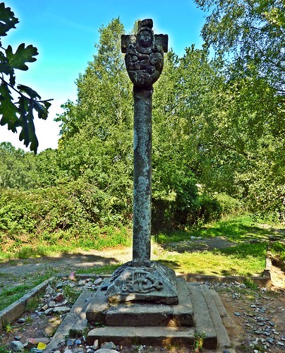
Lameiros and the next village of Ligonde is a 17th-century cruceiro (stone cross).
200 m past Lameiros is the
17th-century Cruceiro de Lameiros,
at the site of the former Capilla de San Lázaro, is said to be the most famous
on the Camino. (Some sources call it Cruceiro
de Lameiros and others Cruceiro de
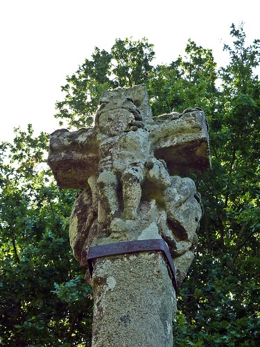
Ligonde.) Erected in 1670, it depicts the Passion of Christ.
It has the
Crucifixion of Christ on one side, with a skull and bones at the base.

Between Lameiros and Ligonde: Cruceiro de
Lameiros - Crucifixion (www.flickriver.com at http://farm4.static.flickr.com/3883/14641179859_566914d827.jpg).
On the opposite side the Virgen
de los Dolores (Virgin of Sorrows). The curving lines and tender pose of the
Virgin, executed in almost abstract style, make it the most moving cross on the
Camino route. (Some sources incorrectly say the latter image depicts the Virgin
and Child, symbolizing motherhood or life in juxtaposition to the death on the
cross.)

Between Lameiros and
Ligonde: Cruceiro de Lameiros - side with Virgin of Sorrows
(www.flickriver.com
at http://farm3.static.flickr.com/2926/14641365387_6d65ebe5cb.jpg).
On the base on the side with the
Virgin of Sorrows are a ladder, some nails, a hammer, and tongs at the base,
symbols of the Deposition (removal from the cross). Around the side of the base is
the crown of thorns.

Between Lameiros and
Ligonde: Cruceiro de Lameiros - crown of thorns, ladder, hammer and nails, and
tongs (www.flickr.com
at https://c1.staticflickr.com/5/4122/4777134646_6fc9c4f2d8_b.jpg).
Then
we came to Ligonde (pop 47?; pop of
parish of Ligonde 196 in 2012).
Ligonde is a hamlet
stretching out along the Camino for several hundred meters. The village has
existed since 956, when it was documented as Ledegundi. Just before entering the town, there is another stone
cross that marks the location of an ancient pilgrim cemetery, which is all that
remains of a medieval pilgrim hospital of the Order of Santiago, which existed
until 1753.
The parish of Ligonde has two
hamlets. The first, at the top of the hill, is known as Ligonde. Ligonde
divides the basins of the rivers Miño and Ulloa and also the Concellos of
Portomarín and Monterosso.
The Casa de Carneiro [house of the ram], a large house at the entrance
to town, displays coats of arms of 3 noble families. Carlos V stopped here in
1520 on his way to be crowned emperor and, in thanks for hospitality, granted
the house the right to offer sanctuary. Felipe II stayed here in 1554, en route
to La Coruna to marry Mary Tudor.
Around
1:23, we reached Airexe (aka Eirexe) (pop 28 in 2012).

1:23 PM – Eirexe: entering town with city
limit sign “Airexe.”
On the other side of the Río
Airexe (aka Río de Irixe), several hundred meters past Ligonde, is Airexe (aka Eirexe or Eirexe de Ligonde
[eirexe, with variants airexe, erexe, and irixe, means
church). It is still in the Parroquia [parish] de Ligonde, in the Concello de
Monterosso. In Airexe, one can stay at the confusingly named Albergue de
Ligonde (although there are two albergues in Ligonde) or the Pensión Eirexe.

1:24 PM – Eirexe: cruceiro (17th century) and
church (Igrexa de Santiago).
The Igrexa de Santiago [Church of St. James], in its present form, is
mainly neo-classical from the 18th century, but it retains the Romanesque
portal of its predecessor (1225-1230?). The portal has some unusual decorative
elements. On its capitals are birds—incised lines indicating their
feathers—picking at plants.

Airexe: Igrexa de Santiago in Parroquia de
Ligonde (gl.wikipedia.org).

Airexe: Igrexa de Santiago - stone slab and door
in S wall (gl.wikipedia.org).
Embedded in the wall next to a
door in the church’s south side under a small protective roof is a large stone
(2.1 X 0.7 m). Some sources say this is the top of a Romanesque grave that is
used as part of the wall of the building; this is probably the “sarcofago
semiantropoide medieval” (or the pre-Romanesque tomb of 1100) mentioned on a
sign near the entrance to town (although other sources say it was perhaps
formerly a lintel). It depicts Daniel in the lions’ den between two lions. At
the bottom is the inscription “RANEMIRUS FECIT” [Ramiro made it].

Airexe: Igrexa de Santiago
– stone slab on S side (gl.wikipedia.org Cropped).
Confusingly, this church is also
known as Iglesia de Santiago de Ligonde (or Igrexa Parroquial de Santiago de
Ligonde), because it is in the Parroquia [parish] of Ligonde, although its
address is in Airexe (de Ligonde).
Opposite the church is an
unpresupposing building locally called Nabal del Hospital or Casa do Rego. [A nabal (Galego for nabar in Castilian Spanish) is a field for planting turnips (nabos). In Galego, a rego is an arroyo or an irrigation ditch.]
It was built as a pilgrim hospital and was still operating in the 18th century.
Up on the hill from the church
are some of the first eucalyptus trees on the Camino route.

1:24 PM – Airexe: 73 km marker “Eirexe.”

1:25 PM – Airexe: hórreo with clothesline.

1:25 PM – Airexe: other side of same hórreo.
Around
1:50, we reached Portos (pop ?), in
the Concello de Palas de Rei. Here we found the albergue A Paso de Formiga [The Pass of the Ant], decorated with giant
sculptures of ants.

1:51 PM – Portos: city limit sign and giant
ant sculptures.

MT 1:54 PM – Portos: Don
(ready for water break) with city limit sign and giant ant sculptures.

MT 1:52 PM – Portos: MT
with giant ant.

MT 1:52 PM – Portos: Don
with giant ant.
Just
past Portos, we came to the village of Lestedo
(pop?; pop 98 in parish of Santiago de Lestedo in 2007).
Lestedo is a village in
the Parroquia de Santiago de Lestedo in the Concello de Palas de Rei.

2:06 PM – Lestedo: Iglesia de Santiago and cruceiro.
The Igrexa Parroquial de Santiago
de Lestedo is a simple church of popular construction. It has a rectangular
nave, two access doors, and the presbytery in the apse. The sacristy is
attached at the back. The roof is tiles with 2 and 4 “aguas.” The façade has a
doorway, with lintel and a small oculus above it, and is topped with a belfry
with two semicircular openings for bells (and a third opening at the top). A
large cemetery surrounds the church.
The cruceiro in front of the church door stands on a quadrangular
pedestal and has an inscription “Misión de Lestedo, año 1860. Se conceden diez
mil años de … rezando cinco veces la oración del Pater Noster Ave María y
Gloria” [Mission of Lestedo, 1860. Ten thousand years are granted of ...
praying five times the prayers Pater Noster, Hail Mary, and the Glory Be].

2:06 PM – Lestedo: Iglesia de Santiago.

2:06 PM – Lestedo: “Bando” [proclamation] from
mayor of Palas de Rei about campaign to vaccinate dogs, posted by church gate.

2:07 PM – Lestedo: km 70 stone marker.
From Portos, there is a 2.2 km (45-minute)
detour to the right (north) to the spectacular 13th-century Romanesque Monasterio de San Salvador [Monastery
of the Savior] at Vilar de Donas.
The current structure dates from the early 13th century, but is primarily 14th
century. It may originally have been a family monastery, which were common in
Galicia. This monasteiro was probably
a nunnery (hence the appellation Donas)
and was founded in the 10th century. The family gave it to the order of
Caballeros de Santiago (Knights of Santiago) in 1184, with the stipulation that
Gallego members of the order were to be buried there. The monastery became the
official burial place of the order. It was much favored by the Castilian
royalty. After the confiscation of Mendrizábal in the 1830s, the monastery
became a parish church.
We
crossed the Alto do Rosario and
passed through the hamlet of Rosario
(pop ?) before entering the suburbs of Palas de Rei..
A woodland path ascends on a
gentle climb to the Alto do Rosario.
From its height (before trees were planted), one could see the cone of the Pico
Sacra (the sacred peak above Santiago) and to the south the Monte Faro (1,000
m). On entering the hamlet of Rosario,
at the sight of the Pico Sacra, pilgrims would pray the rosary, hence the name.
Now there are enormous oak trees along this section of the Camino.
We
arrived in Palas de Rei (pop 4,537) at
3:15.
Palas
de Rei
[Palace of the King] (or Pallatium Regis
[Royal Palace] as it was known in the Middle Ages), according to legend, was
given this name by the Visigoth King Witiza, who supposedly built a palace
here, although the palace disappeared long ago. Witiza (Wittiza, Witica,
Vitiza, or Witiges) was born ca. 687 and probably died in 710; he ruled
Hispania from 694 until his death. Witiza was the last of the militant Arian
heretics (who held that Jesus is the Son of God, but subordinate to God the
Father, who created Him, rather than being “consubstantial with the Father”). However,
Roman and Celtic remains in the surrounding area indicate much earlier
settlements here. The name of the town does not appear in historical documents
until the 9th century and is mentioned frequently in documents from the 12th
century. Palas de Rei has always been an important stop on the Camino and
marked the end of the 12th stage in the 12th-century Codex Calixtinus. There is not much left from the town’s 12th-century
heyday, except for the main façade of Igrexa de San Tirso and the façade of a
medieval house that is decorated with the famous scallops of the Camino.
However, there are a number of pazos [manor
houses] and noble houses dotted around to show the affluence of the area.
We
found Pensión Casa Curro with a
double room for 40€ (no breakfast). This was far better than last year, when we
had to walk clear out of town to find lodging. We got sellos at the pensión.

4:11 PM – Palas de Rei: Pensión Casa Curro
exterior.

MT 4:16 PM – Palas de Rei: Pensión Casa Curro
– sign by entrance.

3:23 PM – Palas de Rei: Pensión Casa Curro -
MT in our room (No. 23).

3:23 PM – Palas de Rei: Pensión Casa Curro –
our room (No. 23).
We
went to a bar for sangrias in Britania
“El Bar” (2 for 4.40€). The bar was just across the street from the city
hall. We met the two ladies from Denver near there.

3:57 PM – Palas de Rei: Britania “El
Bar" – MT at right.

MT 4:09 PM – Palas de
Rei: Don with 2 ladies from Denver.
Then
we went to a farmácia (pharmacy)
where MT got a cream for likely bed bugs (the lady pharmacist said this was
“normal” on the Camino route), then back to the pensión for bath. (Don had no
problem.)
Don
went back to check on the church, Iglesia
de San Tirso, we had passed. The sign on the church door said it would open
at 4 pm, but Don had to wait until after 4:30 and found out there would mass at
8 pm.

4:13 PM – Palas de Rei: pilgrim cross on
sidewalk on way back up to church.
Documents from the 9th century
refer to a church on this site. However, the current Iglesia de San Tirso was originally built in the late 12th and
early 13th century, but has undergone numerous changes over the centuries and
the only original part is the modest Romanesque west portal. The portal has two
archivolts, a plain (smooth) tympanum, and foliated capitals.

4:15 PM – Palas de Rei: Iglesia de San Tirso
façade.

4:16 PM – Palas de Rei: Virgin and Child statue
in front of Iglesia de San Tirso.

4:17 PM – Palas de Rei: Iglesia de San Tirso
– right (south) side and bell tower.

Palas de Rei: Iglesia de San Tirso - apse, tower, and cruceiro
(www.panoramio.com).
At
6:30, we went to eat the 9€ menu in Pensión
Casa Curro, served by the lovely lady who owns it: 1st course: caldo gallego (served in a large bowl
from which we each filled our bowls twice); 2nd course: both had merluza con patatas cocidas [hake with
boiled potatoes] (with red sauce); dessert: MT asked for cheese with (quince)
marmalade/Don tarta de Santiago;
bottle of red wine from Ourense; bread (she brought more after the soup); half
bottle of water.

7:06 PM – Palas de Rei: Pensión Casa Curro –
MT with waitress/owner when she brought more bread.

7:07 PM – Palas de Rei: Pensión Casa Curro –
owner serving merluza and potatoes to MT.

7:07 PM – Palas de Rei: Pensión Casa Curro –
owner getting ready to put lid on pot after serving merluza and potatoes.
We
went to the 8 pm mass at Iglesia de San
Tirso. There were 4 priests, two of which were pilgrims—an Italian we had
seen concelebrate twice before and a tall bearded man we had seen many times
and suspected was a priest—when we met him again later, we found that he was
from Morgantown, WV. A middle-aged man played guitar and led songs. The celebrant
mentioned pilgrims at the start of mass and during his homily; he also did a
special prayer for pilgrims at the end of mass (in Spanish, French, English,
and Portuguese). We got sellos in the church.
I enjoyed your photos, information and story of your journey through this portion of the Camino where I walked in early October, 2013 and remember so well. I'm glad I clicked on the tweet that led me to your blog.
ReplyDeleteEnjoying reading about your Camino travels. I am in Palas de Rei now and heading to 8:00 PM mass. Have met so many we wonderful pilgrims on my journey.
ReplyDeleteI am so thankful for your stories and pictures ... prayers for both of you ... I myself went on a Camino.
ReplyDelete