We
ate breakfast at the bar across from the pensión (3.50€ each): coffee/hot
chocolate; 2 orange juice; 2 toast with marmalade. We departed at 9 am.
Just
outside the city limits of Palas de Rei along the road between there and Carballal,
we passed Pensión Ponterroxan, where we had stayed last year.

9:12 AM – Between Palas de Rei and Carballal:
Pensión Ponterroxan.
The fields west of Palas de Rei
are called the Campo dos Romeiros
[field of the Romans]. From here to Melide, the road traverses several forests
of eucalyptus, planted for paper and lumber. These forests are interspersed
with cornfields.
Around
9:19, we came to Carballal (pop 16),
the first of 2 towns by that name we would pass through this day. This Carballal
has a lot of hórreos.

9:19 AM – Carballal: hórreo (it had another one behind it).

9:19 AM – Carballal: second hórreo (behind the
first).

9:37 AM – After Carballal: path around road
construction (a big hole in the sand); wind turbines in distance, beyond low-hanging clouds.
Around
9:40, we came to San Xulián (pop ?).
San
Xulián
(aka San Xulián do Camino or San Xiao do Camino or San Julián del
Camino) has a tiny church dedicated to St. Julian—and, of course, more hórreos.

9:42 AM – San Xulián: large (old) hórreo.

9:43 AM – San Xulián: another hórreo, with red tile roof.

9:43 AM – San Xulián: 2 more (modern) hórreos, again with red tile roofs.

9:44 AM – San Xulián: side of the 2nd of those
2 hórreos, with tile roof.

9:44 AM – San Xulián: end and side of (same) 2nd
of those 2 hórreos, with tile roof.

9:45 AM – San Xulián: another hórreo and cruceiro (Iglesia de San Xulián in background).

9:45 AM – San Xulián: close-up of that hórreo.
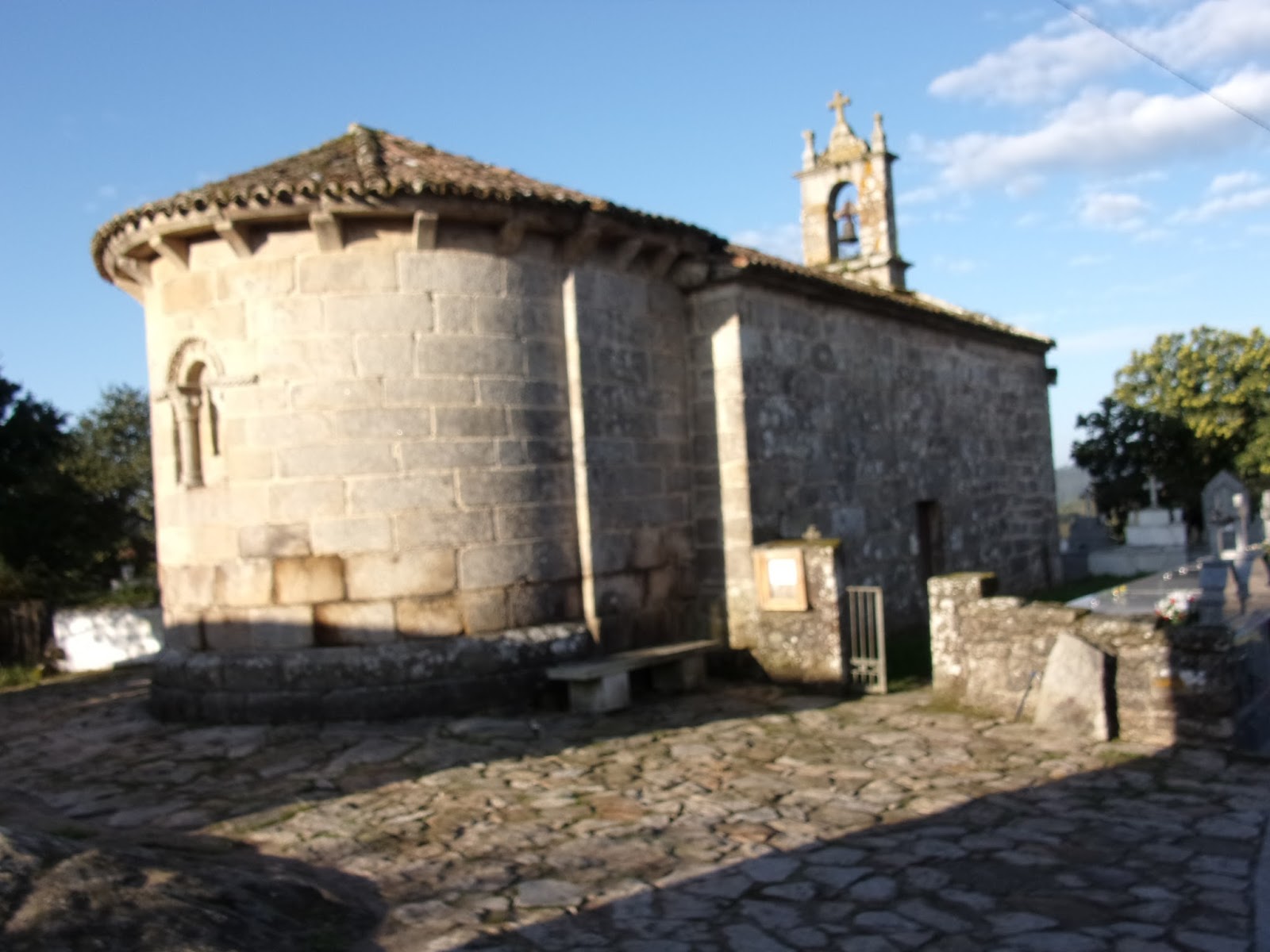
9:45 AM – San Xulián: exterior apse and belfry
of Iglesia de San Xulián.
In the center of town is a
historic cobblestoned area with a stone cross (cruceiro) and the Romanesque Iglesia
de San Xulián, founded in the 12th century and still has some Romanesque
elements, although it was substantially transformed in the 18th century. The
simplicity of the foliated capitals and undecorated corbels suggest Cistercian
models. The slightly horseshoe-shaped arches recall Asturian or Cordoban
styles. The local architecture is very different here, with roofs made of tile
rather than slate.

9:46 AM – San Xulián: another hórreo.
At
9:52, we came to A Graña [the farm] (pop ?), not
on Brierley map. This is still part of Concello de Palas de Rei.

9:52 AM – A Graña: entering town, with city
limit sign.

9:58 AM – A Graña: 2 old hórreos (from left
side).

9:58 AM – A Graña: same 2 old hórreos (from
right side).
From A Graña, the path climbs
gently through ancient oak woods. It crosses the Río Pambre, where there are
the remains of an ancient granite bridge, Pontecampaña [bridge of the
countryside].

10:08 AM – Near Casanova: looking back on
wooded path with 2 levels (higher one for when the lower is flooded, which it
was not at this time).

10:08 AM – Near Casanova: MT on same wooded
path, ahead.
At
10:16, we reached Casanova (pop ?)
still under Concello de Palas de Rei.

10:16 AM – Casanova: entering town, with city
limit sign and hórreo.

MT 10:18 AM – Casanova: Don by city limit sign
(or is he the Casanova?).
At
10:50, Don made an emergency stop in a cornfield around km 95, between Casanova
and O Coto.

MT 10:52 AM - Between Casanova and O Coto: Don’s
cornfield.

MT 10:53 AM - Between Casanova and O Coto: the
path ahead from cornfield (while MT was waiting).
We
stopped at Bar A Campanilla in the hamlet of Campanilla [Bell] (pop ?), the last village in the province of
Lugo, 11:00-11:30 for a pincho de
tortilla, and bought bread and bananas.
Around
O Coto [means “the boundary”] (pop 24),
we crossed from the province of Lugo into the province of A Coruña. More specifically, we entered the Concello de Melide.
The province of A Coruña (still in Xunta de Galicia) is
the 7th and last province on the Camino, since Santiago de Compostela is
located in it. From here on, the stone markers began to indicate changes or
direction, as well as giving the name of where you are and how many km to
Santiago.

11:06 AM – O Coto: Bar A Campanilla: small,
modern hórreo and aseos (baños)
behind the bar; white sign says: “Aseos solo por clientes – Toilets for
customers only.”

11:29 AM – O Coto: Bar A Campanilla: front of
bar (at our departure).
Next,
around 11:50, we came to Leboreiro
(pop 51, parish of O Leboreiro has pop 84).
The name Leboreiro (aka O Leboreiro)
means field or land of hares (liebres).
In the Middle Ages, it was called Campus Leporarius [field of hares] (or Campus
Levurarius, as in the 12th-century Codex
Calixtinus).

O Leboreiro: cruceiro (de.wikipedia.org).
A majestic stone cross (cruceiro) welcomes pilgrims and leads to
the main street, which is flanked by a number of traditional stone houses, some
better preserved than others. The village had its heyday in the 11th to 13th
centuries, when it offered important services to pilgrims. The fact that the
village is not mentioned in later itineraries is an indication that it declined
sharply after that.

11:50 AM – Leboreiro: 2 hórreos, with laundry on
line.

MT 11:50 AM – Leboreiro: MT with yellow arrow
of scallop shells.

11:52 AM – Leboreiro: round granary (a cabazo) with sides of interwoven branches and thatched roof;
building behind with armorial shield was pilgrim hospital.
Just
outside the church is a cabazo (or cabaceiro). This is one
of the few cabazos still found in
Galicia.
Cabazo (Cabaceiro,
Cabaceira). The term cabazo (or cabaceiro or cabaceira)
refers mainly to the hórreo de corres (Spanish: hórreo de varas [hórreo
of branches, sticks, rods]), a kind of hórreo
used in Galicia and northern Portugal, which is less elaborate that the
Galician hórreo or the Asturian one.
It is peculiar basket-like round wooden/thatched granero [granary] (usually made of willow branches). It is similar
to an hórreo, but used mainly for
storing fruit.
The word cabazo and its variants (cabozo,
cabaceiro, and cabaceira) come from the term cabaza
[pumpkin, squash], a fruit that is often left to dry on tornarratos, plates located between pillars and a barn that aim to
prevent access of small rodents into its interior. According to other experts,
the name comes from the pre-Roman calapaccia,
meaning “covered by a shell,” likely referring to the shape of its roof of
vegetation. Another explanation relates the word cabazo to the Latin capio,
capere, used to designate containers and utensils of capacity. The term cabazo is used primarily for a granary
of sticks; however, because of the functional similarity, it is used in some
areas of Galicia for the Galician hórreo.
The cabazo or hórreo de corres is formed by a body of walls
of caínzo [woven sticks] and covered
by a small roof of xesta [broom] or colmo [thatched] called corucho [cap of straw on top of a
stack]. This body of woven sticks is supported by a wooden grid or frame
resting on four legs of wood or stone. The floor is of wooden boards. Fitted
into the grid are thick twigs that are woven, with thinner ones toward the top,
giving it the rounded shape of an inverted truncated cone. The resulting body
has a small, vertically sliding door at the bottom. The most elaborate ones
have a narrow rectangular shape and vertical walls, with a narrow access door on
the shorter side, which results from a later adaptation of a circular type in
imitation of the form of the Galician hórreo.
These baskets are covered with a roof of flat strands when the barn is
rectangular, conical, or circular. At harvest time, the roof is removed to fill
it from the top. The larger ones, to avoid removing the roof, have a larger
door higher than the small door at the bottom.
A cabaceiro is a
bell-shaped granero [granary] made of
interwoven branches and covered with thatch or broom, used for drying corn on
the cob. In Galicia, cabaceiros are
only those interwoven with chestnut, oak, or willow branches into a round
shape. They could be bell-shaped or cylindrical and could be used to conserve
other products, one of which could be cabazas
[Gallego for pumpkins, squashes, or gourds], which give it its name.
A cabaceiro that is prolonged horizontally is called a cabaceira.
A cabaceira (in Gallego) is a vine
that produced squashes or pumpkins.
For more information on cabazos and related structures, see
Appendix B at the end of this blog.

MT 11:53 AM – Leboreiro: Don with round granary (cabazo).

11:52 AM – Leboreiro: Igrexa de Santa María
façade and belfry.
At the far side of town, across
the Rio Seco, is the 13th-century late-Romanesque Igrexa de Santa María (some sources say Gothic with some Romanesque
features and call it one of the best examples of Galician Romanesque
transition). It has a lovely carved Romanesque tympanum above the main door with
a relief of Virgin and Child flanked by angels swinging censers. However, the
church was rebuilt in the 18th century and given a wood roof. Supporting the
roof are a variety of interesting Romanesque corbels, including one very
obvious phallus.
The Iglesia de Santa María was
built to house a statue of the Virgin. Villagers following a lovely smell and a
glowing light supposedly found the statue at a local fountain. For several
days, they placed the Virgin on their church altar but by the next morning it
would return to the fountain. Eventually, the villagers decided to honor the
Virgin by carving a tympanum and dedicating the church to her. At that point,
the statue remained calmly on the altar and is still in the church.
The Casa de la Enfermería, an old pilgrim hospital, is just opposite
the church. The hospital was founded in the 12th century. A document dated 1172
says that it belonged to the Monastery of Sobrado (near Arzúa). However, by the
15th century, it was a property of the wealthy Ulloa family, whose coat of arms
is still preserved on the façade. In recent times, it has served as a hay barn.

11:53 AM – Leboreiro: Igrexa de Santa María
main door with Virgin and Child on tympanum.

11:53 AM – Leboreiro: Igrexa de Santa María –
close-up of Virgin and Child on tympanum above main door.
According to https://de.wikipedia.org/wiki/Leboreiro,
there is an old Roman road northwest of Leboreiro with a bridge over the Río
Seco, and the Camino follows its restored trace for a few hundred meters.
Beyond Leboreiro, the countryside
is now much drier, with fewer trees and more thorn, broom, and heather.
Just
after Leboreiro, we crossed the humpbacked 14th-century Puente María Magdalena (Magdalena Bridge) over the Río Seco [dry
river] into the hamlet of Disicabo
(Disecabo or Desicabo).

11:56 AM – After Leboreiro: MT on medieval
Magdalena bridge.

11:58 AM – After Leboreiro: medieval Magdalena
Bridge – metal clasps holding stones of bridge rail in place (view from top).

MT 11:59 AM – After Leboreiro: shadows of MT and
Don on Puente María Magdalena.

MT 12:01 PM – After Leboreiro: green figs across
the fence.
Shortly
before 1 pm. we crossed the fine medieval [or Roman?] bridge Ponte Velha [Old Bridge] (aka Ponte de San Xoán [Bridge of St. John]),
over the Río Furelos into Furelos
(pop ?; parish of Furelos has pop 248), which is now merged into the larger
town of Melide. The bridge as at the junction of the Camino Primitivo with the
Camino Francés.
This bridge was mentioned in
documents of the 12th century; it was partially altered in the 18th century. It
is 50 m long and 3.7 m wide. It is made up of four unequal semicircular arches.
The three pilasters have triangular cutwaters up river and buttresses down river.
The 13th-century Iglesia de San Juan
(Igrexa de San Xoán) [Church of St.
John] is still there, on the other side of the bridge, but there is no trace of
the pilgrim hospital that used to adjoin the church. All that remains of the
old Romanesque church is the south wall, with its eaves featuring corbels. The
current church was reconstructed in the 20th century.
The village of Furelos takes its name from the Río
Furelos that runs through it. It once belonged to the Hospitallers of San Juan.
An old house just past the bridge on the left was a pilgrim hospital, also
mentioned in a 12th-century document. Another large house in the village was originally
part of the Hospitaller holdings.
The parish of Furelos, like much
of this area, was inhabited long before the Roman conquest.

12:52 PM – Furelos: Ponte Velha into Furelos.

MT 12:53 PM – Furelos: Don on Ponte Velha.

12:54 PM – Furelos: hórreo with Santiago cross.

MT 12:55 PM – Furelos: MT by that hórreo.

MT 12:56 PM – Furelos: MT by hórreo, with Santiago cross.
Just
across the bridge, we stopped at River’s Bar for red wine. There we met 2
priests. The tall, bearded one from Morgantown, West Virginia and one with sore
feet (James Kauffmann, from Richmond, VA) who was at the North American College
and Gregorian in Rome around 1976 and thought he knew our friend Fr. Mike
Stubbs, who also studied there around the same time.

12:59 PM – Furelos: River’s Bar: Fr. James
Kauffmann and his bearded priest friend from Morgantown, WVA; MT with her
iPhone at right.

MT 12:59 PM – Furelos: River’s Bar - Fr. James Kauffmann.

1:25 PM – Furelos: sign for “Casa-Museo
Furelos no Camino” with carving of Ponte Velha on wall across from River’s Bar.

1:26 PM – Furelos: Iglesia de San Juan –
façade and belfry, with small “hórreo” on wall in front of church (and Fr.
James Kauffmann).

MT 1:27 PM – Furelos: River’s Bar – menu for
“Tarta de Santiago – Santiago’s Cake 2.00€.”
After
passing through modern suburbs, we arrived in the old center of Melide (pop 8,000) around 1:45.
The origins of Melide go way back, over 4,000 years,
evidenced by the megalithic dolmens or burial chambers that can be found scattered
around the locality. The site of the town was inhabited in Celtic times and in
Roman times was certainly a villa that took its name from its owner and was
called “mellitus.” This was once an important intersection of the Roman Via Trajana and the northern roads
descending from the Cantabrian coast. The village is documented as early as the
8th century in the will of the bishop of Lugo (in the following centuries, it
belonged to the bishoprics of Oviedo, Mondonedo, and Santiago).
The actual town of Melide dates
back to the 10th century but it appears to have gained more prominence when
King Alfonso IX gave the land surrounding Melide to the Archbishop of Santiago
in 1212. Curiously for a market town and transportation hub, the town was
largely defenseless. In 1320, the Archbishop of that time built a castle and
walled in the town to fortify it, but these were destroyed during the
Irmandiños uprising, and after that the Catholic Monarchs Ferdinand and
Isabella prohibited their reconstruction. The ruins of the castle and walls
were used to build the monastery and hospital of Sancti Spiritus in the 14th
century (today only the Gothic church is preserved).
In the Middle Ages, the Camino
road was Melide’s most important feature, and the town strung its businesses,
hospitals, and residences in a long, thin line along the highway, which the
locals called merely “la Calle” [the street]. Most of the town’s families were innkeepers,
and there were 4 large pilgrim hospitals.
The old part of Melide follows
its medieval layout with narrow winding streets with shops, bars, and
restaurants serving the regional specialty, pulpo
(octopus). The restaurants here typically specialize in pulpo a la feria, where the octopus is cooked in large copper
cauldrons and served on wooden platters sprinkled with paprika and olive oil,
best enjoyed with bread and a cold glass (or bowl) of Albariño or Ribeiro, the
wines made in Galicia. Guidebooks recommend trying this at the traditional
Pulpería Ezequiel.
Melide is where the Camino
Primativo from Oviedo joins the Camino Francés route.
We
stopped to buy fruit in a tienda that also had homemade bread shaped like a
giant doughnut.

MT 1:49 PM – Melide: son of tienda owner family
(right) with large round bread and a customer (left) with local cheese.
Then
we paused to take photos of Pulperia Ezequiel
(where we had eaten last year).

1:48 PM – Melide: Pulpería Ezequiel -
exterior.

1:49 PM – Melide: Pulpería Ezequiel – menu by
front door.

1:49 PM – Melide: Pulpería Ezequiel – man
cutting octopus tentacles with scissors, to put on wooden plates.
The pulpo a la Gallega (steamed octopus sprinkled with paprika and
drizzled with olive oil) is served on rustic wooden platters and eaten with
toothpicks. It is washed down with
characteristically cloudy Ribeiro wine served in ceramic cups.
The pulperias [octopus restaurants] of Melide have the reputation of
having the best pulpo that is
prepared in Spain.
Next,
we came to the Igrexa de San Pedro y San
Roque with the famous Cruceiro de
Melide.

1:50 PM – Melide: Igrexa de San Pedro y San
Roque.
The 18th-century Igrexa de San Pedro y San Roque (aka Capela de San Roque) was built
in 1722 using stone from two former medieval churches, that of the parish
church of San Pedro and the original Capela de San Roque. When the church of
San Roque fell into ruin, its Romanesque door was moved to San Pedro. The
present-day chapel of San Roque was built in 1949. Its main façade, from the
beginning of the 14th century, is one of the most beautiful of Galicia’s
medieval art. Its main door is framed by two bulwarks with a slight projection,
made up of three semi-circular archivolts, featuring elements that clearly
reflect Gothic aesthetics: columns with small shafts and high bases, and
capitals with plant decorations. The church contains some 14th-century tombs.
On the left side of that church is the
14th-century Gothic stone cross, Cruceiro
do Melide, said to be the oldest in Galicia; however, only the top half in
original, with the bottom stone column and base as modern additions. On the
granite cross at the top, the front side depicts a seated Christ in Majesty, crowned,
seated with cloth covering his legs, and showing the wounds on his hands; the
back depicts a Calvary scene, with the Virgin, St. John, and a kneeling figure beside
the Virgin. The cross may have come from the Igrexa de San Pedro in Melide. (The
website of Concello de Melide calls this Cruceiro de San Roque.)

1:51 PM – Melide: Cruceiro de Melide (next to
Igrexa de San Pedro y San Roque) – side facing street with Christ in His
Majesty.

Melide: Cruceiro de Melide – close-up of side with Christ in Majesty
(gl.wikipedia.org).

1:52 PM – Melide: Cruceiro de Melide (next to
Igrexa de San Pedro y San Roque) – other side with Crucifixion of Christ.

Melide: Cruceiro de Melide – close-up of side with Crucifixion (www.areasantiago.es).
We
ate our fruit in a park across from the Iglesia de San Pedro y San Roque.
On
the way out of Melide, we saw another cruceiro
(with crucifixion on one side and backside blank) and the Igrexa de Santa María de Melide.

2:28 PM – Melide: another cruceiro near the
end of town (backside blank); Igrexa Santa María de Melide apse in background.

2:29 PM – Melide: 12th-century Igrexa Santa
María de Melide – side with entrance and belfry.
The 12th-century Igrexa de Santa María de Melide,
classified as a National Monument, it is a gem of Melide’s Galician Romanesque
style. It has 2 decorated entrances, one of which (the door of the main façade)
has a simple tympanum. The west door has a triple archivolt with unusual inset
designs and intensely decorated capitals. The capital on the right portrays
Daniel flanked by 2 lions. The one at the left has 15 palmettos. Two windows on
the south side are columned, arched, and capitaled in the Jaca (checkered)
style.
Just
beyond the Igrexa de Santa María, a bridge crosses the small Río Lázaro (aka
Arroyo de San Lázaro).
After Melide, the Camino path
winds through shaded forest, oak and chestnut increasingly giving way to
eucalyptus and pine. There is very little change in altitude on the Camino from
Melide to Arzúa, but the path continually goes up and downhill, since numerous
small rivers in the region have cut deep valleys. Many of the small villages preserve
their ancient—or at least premodern—rural Galician atmosphere. There are many palleiros [literally haystacks (or piles
of corn or straw), but also haylofts for cattle], pallotes [straw-covered huts called that may be used to store hay
(in which case it is a diminutive of pallal,
hay barn), or they may be stacked bundles of cornstalks], and outdoor ovens for
cooking brona [cornbread]. Many
wooden carts parked in sheds, behind houses, and in barnyards were commonly in
use as recently as the 1970s.
Shortly
after crossing the Rio Lázaro, we passed through our second town called Carballal (pop ?) on this stage.
After
Carballal, we crossed the Río Raido over a narrow granite walkway that pilgrims
must take single file.

2:50 PM – After Carballal: MT on stone bridge
for when lower path is flooded (as it was this day).

2:50 PM – After Carballal: MT on stone bridge
(telephoto, 133 mm).

2:50 PM – After Carballal: MT at far end of
stone bridge, and other pilgrims gathered around for sellos (stamp with wax
seal) from a Special Olympics man with an artificial leg.

2:50 PM (Cropped)– After Carballal: MT at far
end of stone bridge, and other pilgrims gathered around for sellos (stamp with
wax seal) from a Special Olympics man with an artificial leg.
We
got sellos: one with a wax seal and another reading “Pedaleando por un sueño -
Ionut Preda – www.elparalimpicoviajero.com”
[pedalling for a dream – Ionut Preda (plus URL)].
At http://elparalimpicoviajero.blogspot.com, is a blog for “Ionut Preda ‘El Paralimpico Viajero’ [The Paralympic Traveler].”
At 27, his right leg was amputated below the knee. With his prosthetic leg and
extensive training, he was able to compete in various Paralympic sports: shot
put, discus, and javelin.
After
Carballal, we passed through the village of Raido (pop?) on the Río Raido.
Between
Raido and Boente, in the village of Parabispo
(pop ?), by a nice hórreo, there was a small table with chairs along the path
with water and baskets of raspberries. There was a sign with the price of the
berries and a metal box for pilgrims to deposit coins. We got self-service
sellos: “El Pequeño Oasis Frambuesas Autoservicio Km. 46.8 Parabispo Melide”
(frambuesas = raspberries).
We
stopped 3:45-4:05 in Boente (pop ?).
Boente is a hamlet
divided in two (Boente da Riba and Boente da Baixo) by the N-547 highway. It is
known for its local fountain, the Fonte de Saleta. In the Arzúa area, the
residents of Boente are famous for producing the best local cheeses.
In
Boente, we stopped at Cafetería El Aleman:
Das Deutsche Café [Coffee Shop The German: The German Café] for baño and
ice cream bars (otherwise we would have had to pay 0.50€ to use the baño).

3:58 PM – Boente: hórreo and Cafetería El Aleman: Das Deutsche Café.

3:58 PM – Boente: sign for “Cafeteria El
Aleman Das Deutsche Cafe.”

4:02 PM – Boente: sign “Se vende esta casa, [this] house on sale” with picture of castle.

4:02 PM – Boente: left end of the actual house
on which that sign was posted on old door at left.

4:02 PM – Boente: right end of the actual
house on which that sign was posted (still no castle).

4:09 PM – Boente: Igrexa de Santiago façade
and belfry.
The Igrexa de Santiago de Boente is documented from the 8th century,
although the current building dates from the 20th century. Two capitals from
the 12th-century Romanesque church are incorporated into the external wall of
the apse.
Around
4:40, we reached Castañeda (pop ?).
It was here in Castañeda that medieval pilgrims would
deposit the limestone rocks they had brought from Triacastela to be fired in a
kiln for lime used in building the cathedral in Santiago. The 12th-century Codex Calixtinus, Chapter III of Book V,
refers to it as “Castaniolla” and says: “This location is famous for its lime
kiln, where pilgrims deposited the stones carried from Triacastela, thus
contributing to the construction of the Cathedral of Santiago.” Today, there is
no sign of the kiln.
Nearby are two pre-Roman castros [hill forts]: Castromil and
Boente.

4:42 PM – Castañeda: hórreo with cross atop one end and a miniature church belfry atop
the other end.

4:42 PM – Castañeda: old stone building with 2
yellow arrows (one on Camino marker post) and cattle-crossing sign (with ugly
pilgrim logo sign under it); pilgrims passing another hórreo in background.

MT 4:43 PM – After Castañeda: sheep grazing at
edge of town.
Around
4:50, we reached the hamlet of Río
(pop ?), not on Brierley map.

4:49 PM – Río: entering (not much of a) town
with a ruined building and sign with stick-figure pilgrim identifying this as
“Río.”
We
finally got to Rivadiso (aka Ribadiso) (pop ?) at 5:30 and still
had 3 km to Arzúa (uphill and it started to rain, after sunshine all day).

5:23 PM – Rivadiso: MT on path into town, with pilgrim sign identifying this as Rivadiso.
The tiny hamlet of Rivadiso (Ribadiso do Baixo [or da
Baixo]) takes its name from its
location on the Río Iso, and the “da Baixo” because it is in a low area, and
Arzúa is higher up. A bridge spanned the Río Iso here from at least 572.
Records indicate that another, Romanesque bridge was built in 1188 and another
in the 13th century. Pilgrims, making a pun on the name of the bridge, Puente
Ribadiso, called it Puente Paradiso [Bridge of Paradise].
There was once a 15th-century
pilgrim hospital, Hospital de San Antón;
it was first administered by a small convent of Franciscan nuns from Compostela
and later (1523) by the Compostelan silversmiths’ guild; it was restored in the
1990s and now serves as an albergue (Xunta), the first house on the right past
the bridge.
Because
we were falling-down tired and because of the big rain storm beginning, we
asked about staying at the Albergue Los
Caminantes [The Walkers] in Rivadiso, but it and their pensión were already
“completo” (full). The man at the albergue called a taxi that took us the last
3 km to Pensión Begoña in Arzúa for 5€.

5:47 PM – Rivadiso: Albergue Los Caminantes –
just before our taxi arrived; MT in doorway; man in red shirt who had called
the taxi for us; albergue van they used to give pilgrims a ride to their next
hostel, Albergue Los Caminantes II, in Arzúa after this one was full (the side
of the van and the web site http://www.albergueloscaminantes.com
shown on it indicate that Albergue Los Caminantes has 2 locations: in Ribadiso
and also in Arzúa).
We
arrived in Arzúa (pop 7,000) around 6
pm.
Arzúa is the last
major center of population before reaching Santiago. It is a bustling town
known for its cheese and honey (queixo e
miel). Arzúa sits in the middle of fine dairy country, and its real claim
to fame is its cheese, the Queixo Arzúa-Ulloa, a smooth creamy cheese made from
cow’s milk similar to that of the breast-shaped Queso Tetilla. Since 1975, each
March, Arzúa hosts an artisan cheese fair that takes place in this comarca [region] and in the neighboring
Ulloa. In the plaza is a modern statue of a cheese maker.
There is archaeological evidence
that this area was already inhabited a few centuries BC by caporos, a Celtic people mentioned by several Roman historians. Numerous
castros [hill forts] indicate that
the region was intensely settled prior to Romanization. It was near the Roman
villa Brevis, next to the road from Braga (now in Portugal) to Astorga. Judging
from its name, after the Christian Reconquest, Arzuá’s new inhabitants came
from the Basque region. The repopulation must have been fairly late, since the
12th-century Codex Calixtinus refers
to it as Villanova [new town]. In the
Middle Ages, it was a dominion of the Archbishop of Compostela. The village
grew rapidly during the 11th century at the height of the Camino's prominence
during the Middle Ages, when Arzúa was traditionally the last stop before
Santiago and supported two pilgrim hospitals. It was walled in the 14th century
and was dependent on the Archdiocese of Santiago until the 19th century. During
most of the Middle Ages, Arzúa was a small, walled village. It is still small,
but the wall is gone.
The Igrexa de Santiago was built in the 19th century over the ruins of
an earlier Baroque church, of which the tower and several altarpieces are
preserved. Several earlier churches dedicated to Santiago on this site had
disappeared.

Arzúa: Igrexa de la
Magdalena (www.areasantiago.es).
In Arzúa is the Gothic Igrexa de La Magdalena (aka Capela da
Madalena), dedicated to Santa María Magdalena, was part of an Augustinian
monastery founded in the mid-14th century (between 1344 and 1351) as a
dependency of Sarria. In the 16th and 17th centuries, the Sarria monks
maintained a small pilgrim hospital here. After the reform of Pius V, the
friars moved to Santiago, and the monastery languished until 1692 and then
began to disappear until not a stone remained. Only the chapel remained, under
the jurisdiction of the monastery in Santiago, and worship was held there until
1835, when it was abandoned. Its tower was destroyed in 1836 during the Carlist
Wars. After that, it was used for various profane uses, from prison to barn or
woodshed. Finally, the city of Arzúa carried out the restoration of this Gothic
gem and for a while used it as a public library.
The church is rectangular, with a
single nave and a nondescript main entrance (with a semicircular arch that
betrays its Romanesque origin) on its façade. Its windows have Gothic ornaments
that indicate its construction in the 14th century.
On the outskirts of town is the Capela de San Lázaro that recalls
another former hospital.
In Arzúa,
we got a double room at Pensión Begoña
for 45€, but with no breakfast and no hanging of clothes in windows.

Monday, September 22, 2014, 9:39 AM – Arzúa: Pensión Begoña exterior; the
ground floor of the building was occupied by BBVA.
Banco Bilbao Vizcaya Artentaria
(BBVA) is part of a multinational banking group headquartered in Bilbao, Spain.

6:06 PM – Arzúa: Pensión Begoña – our room
(No. 203).

6:06 PM – Arzúa: Pensión Begoña – MT in our
room (No, 203).

MT 6:11 PM – Arzúa: Pensión Begoña – English
part of “Internal Rules” posted on inside of room door.

6:18 PM – Arzúa: Pensión Begoña – Don Keen
shoes with heels getting much worse.
We
ate the 10€ menu (total $26.77) at Casa
de Comidas Chelo (recommended by the pensión): 1st course: MT sopa de verduras [vegetable soup]/Don ensalada rusa [Russian salad]; 2nd
course: both had Lomo de Ternera
(translated as loin of veal, but it was stewed with potatoes); dessert: MT
asked for local cheese with (quince) marmalade/ Don tarta de quesa [cheese cake]; wine.

8:40 PM – Arzúa: Casa de Comidas Chelo – Lomo
de Ternera with potatoes and tomatoes.

9:33 PM – Arzúa: Pensión Begoña (MT at
entrance on right) above BVVA bank and nearby buildings.

9:34 PM – Arzúa: Pensión Begoña exterior,
above BBVA bank.
I like "Do not cause riots"
ReplyDeleteI also like No. * "The cost of the room must be paid upon arrival." You would not have got that far if you had disobeyed that rule.
ReplyDelete