At
6:30, Don ate breakfast at Bar-Restaurante
Loncho: tostadas con tomate y aciete;
hot chocolate (ColaCao) (3€). The man behind the bar offered more tostadas (Don took one, no charge); he
later asked if Don needed any more. Don read about the last stage while waiting
for the sun to come up. In the pockets of his rain jacket, Don kept gloves for
the cold morning and his headlamp for the dark.

Olveiroa to Muxía Map (caminodesantiago.consumer.es).
Don finally departed at 8:10, with little sun through a thick fog.

8:13 AM – Olveiroa: stone hórreos and church in heavy fog.
Heading uphill out of Olveiroa,
there is a castro (hill fort) on the
left. There are great views of the river in the gorge below and of hills with
wind turbines.

8:18 AM – After Olveiroa: path overgrown with
trees, looked like a tunnel.

8:25 AM – After Olveiroa: clouds below mountain
ridges and sun on horizon.

8:26 AM – After Olveiroa: wind turbines in
fog, along dirt path.

8:31 AM – After Olveiroa: clouds and sunshine
in mountains; river Río de Hospital barely visible below.

8:39 AM – After Olveiroa: clouds and
sunshine in mountains.

8:39 AM – After Olveiroa: clouds below
mountains; wind turbines on far ridge.

8:42 AM – After Olveiroa: river Río de
Hospital below through clouds in mountains.

8:43 AM – After Olveiroa: river Río de
Hospital below through clouds in mountains (focused light reading on river).

8:53 AM – After Olveiroa: finally, sun rising
over mountain to E; wind turbines on ridge.

8:56 AM – After Olveiroa: Don’s shadow from
rising sun.
The route follows a dirt track
into Logoso.
Around
9 am, Don arrived in Logoso (pop ?).

9:02 AM – Logoso: Albergue-Bar O Logoso.

9:05 AM – Logoso: Albergue-Bar O Logoso – bar
part and sign for Albergue.

9:03 AM – Logoso: stone hórreo (4 pairs of legs) with cows underneath.

9:05 AM – Logoso: hard-to-see yellow arrow on
corner of building.
As
Don made that left turn, the paved road came to an end and he was faced with a
fork of two paths—which one to take?

9:06 AM – After Logoso: at end of paved road,
a fork of paths—which one to take?

9:06 AM – After Logoso: at end of
paved road, a fork of paths—a careful took would show a Camino marker stone on
the higher path to the left and even a spray-painted yellow arrow on the post
of the sign between the paths (the arrow points straight [up the higher path]
while the sign itself points to something on the righthand path.
The CSJ notes said: “Continue to
the end then take upper of two tracks, undulating, high up, across the shoulder
of the mountain.”
So
Don took the higher path.

9:06 AM – After Logoso: Camino marker stone
on upper path at fork.

9:18 AM – After Logoso: Don’s shadow, taking
BIG strides.
Around
9:23, Don reached Hospital (pop ?).
The village of Hospital is likely, given its name, to
have had a pilgrim hospital in centuries gone by. The village was destroyed by
Napoleon’s troops during their advance into Spain. What is has today is a large
carbide factory. It is also near the point where the routes to Finisterre and
Muxía divide.

9:23 AM – Hospital: approaching the village;
wind turbine on hill behind it.

9:23 AM – Hospital: carbide factory
(telephoto, 112 mm).
At
the far side of Hospital, Don found the very nice Pilgrim Information Center, where he got a nice map of Concello de Dumbría and surrounding
regions, some good directions in English, and a sello: “Dumbría – Llévatela www.dumbria.com.” Llévatela is
Spanish for “take it with you.”

9:26 AM – Hospital: Pilgrim Information
Center.

9:34 AM – After Hospital: wind turbines over
cornfield.

9:36 AM – After Hospital: sign for “Camino
Finisterre – Last Bar for 15 km – Cee – Eat and drink now – Thanks!” (Cee is
the next major town on the way to Finisterre, if you turn that way.) Behind the
sign to the left is the carbide factory; to the right is the sign for leaving
Hospital.

9:37 AM – After Hospital: “29,353 KM” Camino
marker post [Spain uses a comma for a decimal point], with yellow arrow.

9:39 AM – After Hospital: closer view of wind
turbines in sun (telephoto, 90 mm).

9:42 AM – After Hospital: highway signs when
approaching the split between Fisterra (Finisterre) and Muxía at top of this
hill.
At
9:44, Don came to the place where the routes to Finisterre and Muxía divide.
The girl at the Pilgrim Information Center had called this a “park,” but it was
actually in the center of a traffic circle on intersecting highways,

9:44 AM – After Hospital: double Camino
marker post – the metal plaques that should have shown the distances to
Finisterre and to Muxía are missing, but there are crude painted yellow arrows
for Fisterra and Muxía.

9:45 AM – After Hospital: traffic circle with
“DUMBRIA” in trimmed hedges and seal of the Concello de Dumbría; wind turbines
in background.

10:00 AM – After Hospital: beginning of the
footpath toward Muxía, with Camino marker post.
CSJ notes say: “In this section
the direction to proceed is indicated by the rays of the ‘shell’ on the
bollards (and which indicate the number of kilometers remaining to Muxía.”

10:09 AM – After Hospital: wooded path with
rock wall.

10:10 AM – After Hospital: decision point of
whether to turn left on paved road or take gravel path off to right? On near
edge of road is a spray-painted yellow arrow pointing across, but also slightly
to left.

10:10 AM – After Hospital: decision
point of whether to stay on paved road or take gravel path off to right?
–across the road, there is a Camino marker post with a yellow arrow pointing to
the gravel path (see red circle).

10:10 AM (Cropped) – After Hospital: Camino
marker post with yellow arrow pointing to gravel path.

10:13 AM – After Hospital: gravel and grass
path.

10:19 AM – After Hospital: rock wall by paved
road and rock fences around field.

10:24 AM – After Hospital: more rock path
with rocky walls.
Around
10:25, Don came to Carizas (pop ?).
Carizas is a rural
enclave of the parish of Santa Baia de Dumbría where pilgrims encounter the
first of the many and diverse hórreos
of the day’s journey.

10:25 AM – Carizas: stone hórreo (5 pairs of legs, no cross).

10:29 AM – After Carizas: sign pointing back
to Carizas (Don had seen no sign when entering town).

10:31 AM – After Carizas: swing on frame
between 2 tree trunk stumps.

10:32 AM – After Carizas: old-fashioned
haystack.

10:34 AM – After Carizas: Don holding a
familiar nut; he finally figured out that “nuts” of that kind came from trees
with this kind of leaves (oak trees with acorns; the lighter end of the nut is
where the cap of the acorn had been).
Around
10:40, Don reached the town of Dumbría
(pop 3,652).
The name, Dumbría, of Celtic origin, probably refers to the existence of an
ancient fortified settlement.
Don
stopped at a supermercado and bought
stuffed olives (1.15€) and a banana (total 1.50€). He ate these for lunch
(11:00-11:20). He got a sello: “Rocio
Castiniera Pazos – Dumbría” [first 2 words were double-stamped and hard to
read].

10:42 AM – Dumbría: Albergue de “O Conco.”

10:43 AM – Dumbría: Albergue de “O Conco” –
entrance.

10:46 AM – Dumbría: intersection – which way
to go? (modern-looking stone hórreo
in background).

10:46 AM – Dumbría: intersection –
which way to go? – there is actually a yellow arrow on the back of the traffic
sign on the median (see red circle); unlike the one near Cores, this is a real
Camino arrow.

10:46 AM (Cropped) – Dumbría: intersection –
which way to go? - close-up of yellow arrow on the back of the traffic sign on
the median and modern-looking stone hórreo.

10:47 AM – Dumbría: large stone hórreo with 8 pairs of “mushroom-style”
legs (a new record [so far]) and 2 crosses on top.

10:49 AM – Dumbría: other side (with door) of same stone hórreo as before, with 8 pairs of legs (a new record [so far]) and 2 crosses.

10:47 AM – Dumbría: sign, next to that hórreo, for “Igrexa de Sta. Baia de
Dumbría.”
Although
that sign pointed to “Igrexa de Sta. Baia de Dumbría,” the church Don saw 1
minute later was actually identified by the sign on its façade as Santa Eulalia
de Dumbría. (On the Internet, all the photos of Santa Baia de Dumbría on
Wikimedia and other sites are actually of Santa Eulalia.)
Igrexa
Parroquial de Santa Eulalia (o Santa Baia) de Dumbría was constructed
in the 17th and 18th centuries. Originally of Romanesque design, its subsequent
reforms were mainly in Baroque style. It has a basilica-like nave with granite
masonry walls. The façade of granite blocks has a tripartite structure formed
by two piers framing a central body with a flat door topped by double archivolt;
the top has a rectangular shape. The façade has an image of the Virgin above
the door and images of San Sebastian and San Roque at the top of its capitals. The
tower consists of two parts, the bottom with square shape and the upper a
truncated pyramid.

10:48 AM – Dumbría: Igrexa de Santa Eulalia
– façade and belfry.

10:48 AM – Dumbría: Igrexa de Santa Eulalia
– façade with sign for “Santa Eulalia Dumbría” above cross, statue of St. Eulalia
(some sources say the Virgin) over door, and statues of San Sebastian and San
Roque on capitals to left and right of door, respectively.

10:49 AM – Dumbría: Igrexa de Santa Eulalia
– statue of San Roque to right of door.

10:50 AM – Dumbría: cruceiro by church.

10:50 AM – Dumbría: Virgin praying on one
side of cruceiro, standing on the
head [of an angel?] (telephoto, 156 mm).

10:51 AM – Dumbría: Christ Crucified on other
side of cruceiro (telephoto, 156 mm).

11:21 AM – Dumbría: Café-Bar Truanés –
Supermercado, where Don bought stuffed olives and banana for lunch (he ate them
at a table on the terraza around the
corner, where the yellow arrow points).

11:24 AM – Dumbría: another hórreo (5 pairs of legs and a Celtic
cross, but with modern-looking stone sides and legs).

11:25 AM – Dumbría: close-up of Celtic cross
on that hórreo (telephoto, 360 mm).

11:27 AM – Dumbría: two more stone hórreos (4 and 5 pairs of legs, no
crosses).

11:30 AM – Dumbría: another stone hórreo (5 pairs of legs, no cross, and
legs look more modern).

11:30 AM – Dumbría: 2 more hórreos (4 and 4 pairs of legs [one on
right seems to have one extra leg with no mushroom top], no crosses).

11:31 AM – Dumbría: other side of those 2 hórreos (in sun).

11:38 AM – Dumbría: busy intersection on way
out of town—which way to go?

11:38 AM – Dumbría: busy intersection
on way out of town—which way to go? If you look closely, there are 2
spray-painted yellow arrows, one on the low concrete wall at the left and
another on a concrete post at the base of the red streetlight (see red
circles). The road to the right goes to Cee and Fisterra (according to the
highway sign arrow at right on far side of road).

11:38 AM – Dumbría: yellow arrow painted on
low concrete wall.

11:39 AM – Dumbría: yellow arrow painted on
concrete post at base of red streetlight; around the corner you can see it’s a
real Camino marker post with rays of shell pointing the way.
As
Don left the town of Dumbría on a paved road, it looked like the Camino might
turn off on a small gravel path (as had been the case earlier this day), but
this is where it paid to go in the direction of the rays of the scallop shell
on the Camino marker post, which indicated to stay on the paved road to the
left.

11:42 AM – Leaving Dumbría: the presence of
a Comino marker post by the possible turnoff onto a small gravel path to the
left seemed to indicate taking that path.

11:42 AM (Cropped) – Leaving Dumbría:
However, the rays of the scallop shell on the Camino marker actually pointed to
the left, meaning to stay on the paved road.
4
minutes later, Don came to another intersection with no apparent
directions—which way to turn? Here, the Camino actually departed the paved road
for a grassy footpath through the woods.

11:46 AM – After Dumbría: Intersection with
stop sign—which way to go?

11:46 AM – After Dumbría: The Camino
actually took neither way on the paved road but veered off on a grassy path
into the woods; look carefully for the Camino marker post on the far side of
the intersection (see red circle).

11:46 AM – After Dumbría: Camino marker post
on other side of intersection with spray-painted yellow arrow (still hard to
see) pointing to grassy path into woods.

11:46 AM (Cropped) – After Dumbría: close-up
of Camino marker post on other side of intersection with spray-painted yellow
arrow pointing to grassy path into woods.

11:47 AM – After Dumbría: grassy footpath
into woods, with stone wall.

11:54 AM – After Dumbría: very grassy
footpath, with stone wall.

11:54 AM – After Dumbría: grassy footpath
with Camino marker on end of stone wall (shell rays pointed up meant straight
ahead).
At
this point, most of the stones in the wall by the path were sparkling in the
sun. Don tried (not very successfully) to capture the sparkles in photos with
and without flash (those without flash seemed best).

11:56 AM – After Dumbría: stone wall with
sparkles.

11:56 AM – After Dumbría: Don tried to catch
sparkles in photo (this one with no flash).

12:01 PM – After Dumbría: more of same path,
with stone walls on both sides.

12:03 PM – After Dumbría: Don tried to catch
sparkles in photo of a larger stone (this one with no flash).

12:12 PM – After Dumbría: path started
downhill.

12:17 PM – After Dumbría: narrow path with
trees.
Around
12:18, Don came to Trastufre (aka
Trasufe) (pop less than 70).
Trastufre has an
outstanding collection of hórreos, a cruceiro, and the Santuario de Nuestra
Señora del Espino.

12:18 PM – Trastufre: view across cornfield
to another hórreo with a Celtic cross
(telephoto, 360 mm).

12:20 PM – Trastufre: sign entering town, a
Camino marker stone (rays and yellow arrow pointing right), and 2 stone hórreos.

12:20 PM – Trastufre: same 2 stone hórreos (6 and 4 pairs of legs, no
crosses, modern-looking sides) by lower road and 2 more hórreos up the road to the right.

12:22 PM – Trastufre: another stone hórreo (5 pairs of legs, no cross); this
one looked older.

12:24 PM – Trastufre: two more stone hórreos (7 and 5 pairs of legs, no
crosses, modern-looking sides).

12:25 PM – Trastufre: other (sunny) side of
those two (modern) stone hórreos (7
and 5 pairs of legs, no crosses).
The Santuario de Nuestra Señora del Espino (Sanctuary of Our Lady of
the Hawthorn) aka Nosa Señora do Espino, aka Virxe do Espiño, aka Virgin of
Aránzazu, aka Capilla da Santiña do Trastufre, aka Capilla do Santiña do Espiño,
is small but well known. The church consists of a simple white Baroque façade
topped by a belfry with two bells. The church was founded in 1785 by the parish
of Coucieiro in order to permit parishioners to attend mass in the winter/rainy
season, which would otherwise have involved crossing the Río Castro, where no
bridge existed. On September 21, the faithful from all over the Costa da Morte
region flock here in a pilgrimage in honor of Nosa Señora do Espino, aka
Santiña do Trastufre. This saint is reputed to cure warts, and thus pilgrims
wash themselves in the fountain known as A Fonte da Santa (the fountain of the
saint) and dry with a tissue called A Silveira da Santa (the blackberry of the
saint). Alms, local produce, and wax figures are offered to the Santiña. The
image of the saint is a one-meter-tall wooden polychrome figure whose origin
dates back to the late 18th century. This image is well known in the peninsula
as the Virgin of Aránzazu (“Arantza Zu!, Arantza Zu!,” an expression that in
Basque language means: “you among the hawthorns!”). The priest who had the
church built was very dedicated to the Virgin of Aránzazu. Almost a hundred
years later, between 1879 and 1903, the church had to be extended due to the
increase in parishioners; at that time A Fonte da Santa was also built.

12:26 PM – Trastufre: church façade with sign
identifying it as “Santuario de Nuestra Señora del Espino.”

12:27 PM – Trastufre: Santuario de Nuestra
Señora del Espino – exterior, right side, with belfry.

12:38 PM – After Trastufre: cleared swath of
eucalyptus, with stack of logs.

12:54 PM – After Trastufre: fields with
stone fences.

12:55 PM – After Trastufre: closer view of
one long stone fence.

12:56 PM – After Trastufre: still green
acorns on oak tree.

12:56 PM – After Trastufre: more still green
acorns on oak tree.
When
Don saw a town ahead around 1 pm, there was a 2-tread dirt path from a bend in
the paved road that led straight through fields into town, but the Camino
markers said to stay on the paved road (with old stone walls on sides) that
wound around and eventually got to the town.
This
town was Senande (pop 224), a good
place for a pause in the middle of this stage.

1:04 PM – Senande: white beans drying on
sidewalk.

1:04 PM – Senande: close-up of white beans
drying on sidewalk (telephoto, 64 mm).

1:07 PM – Senande: Camino marker post, hórreo-shaped bus stop (with “Senande”
on end and “Concello de Muxía” on side) and sign for Agrodosio, Vilastose, and
Casanova (to left).
Don
stopped at the first bar (A Coxa),
which had no helado (ice cream), but
the owner pointed him to the next bar, around the corner to the left, which had
a limited selection. Don got a small vanilla cone with a little chocolate
(1.10€) and a large bottle of cold water (0.75€) to refill his water bottle and
drink some here. This bar had no sign with the name, but Don got a sello: “Casa Rego – Ultramarinas – Bar – Estanco – Senande” [Casa Rego - Groceries
– Bar – Tobacconist - Senande]. Don departed at 11:36.

1:08 PM – Senande: Casa Rego, where Don
bought ice cream and water and caught up on his notes.
Around
1:35, Don reached Agrodosío (pop 22).

1:35 PM – Agrodosío: sign pointing into
town; stone hórreo in background.

1:37 PM – Agrodosío: A colorful Italian
pilgrim, going in reverse.

1:38 PM – Agrodosío: another city limit sign
and 2 more stone hórreos (1st one
with a cross, supported by 2 transverse walls [cepas] rather than legs, and with many steps; 2nd one with 6 pairs
of legs).
Around
1:42, Don came to Vilastose (pop 64).

1:42 PM – Vilastose: sign entering town,
with a Camino marker post and a yellow arrow on utility pole.

1:43 PM – Vilastose: cruceiro (with its shadow on white van) by private house.

1:44 PM – Vilastose: cruceiro by private house – side with pieta (Virgin Mary holding dead Son).

1:44 PM – Vilastose: cruceiro by private house – side with crucifixion.
At
1:44, Don already found himself in A
Grixa (pop 28).

1:44 PM – A Grixa: city limit sign and
Camino marker stone (far right) when entering town at intersection—which way?

1:45 PM – A Grixa: the rays of the shell and
the yellow arrow on the Camino marker stone “16,134 KM” said to turn right.
Here
he saw a cruceiro opposite the Igrexa de San Cibrán de Vilastose. The
church has a Baroque bell tower separate from it on a higher level.

1:47 PM – A Grixa: cruceiro and (on higher level, behind wall) a stone hórreo and the bell tower of church of
San Cibrán de Vilastose.

1:48 PM – A Grixa: side of cruceiro with crucifixion (telephoto,
156 mm).

1:48 PM – A Grixa: side of cruceiro with Madonna (telephoto, 156
mm).

1:49 PM – A Grixa: Baroque bell tower
separate from church, up some steps.

1:50 PM – A Grixa: Igrexa de San Cibrán de
Vilastose – façade; top right corner seems to have stub of an old bell tower.

1:51 PM – A Grixa: Igrexa de San Cibrán de
Vilastose – right side; apse (at right) and other end (toward façade) seems to have
the stub of an old bell tower.

1:51 PM – A Grixa: ruins of rectory by
church (sign for “Rectoral” to top right of green doors).

1:52 PM – A Grixa: stone hórreo (6 pairs of legs, no cross, doors on end and side).

1:53 PM – A Grixa: 2 more stone hórreos with no crosses; one on left
with 3 pairs of legs and modern-looking concrete sides, the one on right with
older stones and 4 pairs of legs.

1:53 PM – A Grixa: other sides of same 2
stone hórreos.

1:54 PM – A Grixa: stone hórreo (9 pairs of legs, new record [so
far]) and cross, modern-looking concrete sides) on top of a building; the
newer-looking concrete-block building may have been built around the bottom of
the existing hórreo, as Don had seen
earlier.

1:55 PM – A Grixa: stone hórreo on top of a building (better view
of 9 pairs of legs).
After
Vilastose and A Grixa, the Camino route veered off the main road onto a
forested path to the northeast toward Quintáns. There was a section of young eucalyptus trees planted in rows. The
trees had 2 different kinds of leaves: one kind with light green leaves, the
other with thinner, dark green leaves. Sometimes, one tree had both kinds of leaves;
perhaps the lighter ones were new growth.
Wikipedia says: “The leaves on a
mature eucalyptus plant are commonly
lanceolate [deeply lobed,
resembling a branch or pitchfork], petiolate [having a leaf
stem], apparently alternate [leaf
attachments are singular at nodes and leaves alternate direction along stem] and
waxy or glossy green. In contrast, the leaves of seedlings are often opposite two structures,
one on each side of stem; leaf attachments are paired at each node], sessile [blade attaches directly to stem], and glaucous [with a whitish
bloom; covered with a very fine, bluish-white powder]. But there are many
exceptions to this pattern. Many species such as E. melanophloia and E. setosa retain the juvenile leaf form
even when the plant is reproductively mature.”

2:16 PM – After A Grixa: young eucalyptus
(bluish-white leaves).

2:17 PM – After A Grixa: taller eucalyptus
(longer, darker leaves).

2:18 PM – After A Grixa: lower-growth eucalyptus
(bluish-white leaves).

2:18 PM – After A Grixa: Don’s hand to show
size of bluish-white eucalyptus leaves.

2:19 PM – After A Grixa: Don’s hand on
bluish-white eucalyptus leaves (contrast to darker leaves on higher growth).

2:19 PM – After A Grixa: both kinds of
leaves on same eucalyptus.

2:20 PM – After A Grixa: 2 very young eucalyptus
trees with different leaves.

2:21 PM – After A Grixa: even younger eucalyptus
trees with both kinds of leaves.
At 2:22, there was a break in the trees, with a stone wall and Camino marker post.

2:22 PM – After A Grixa: stone wall with red
arrow pointing back to Olveiroa.

2:22 PM – After A Grixa: Camino marker post
with red arrow and rays of shell pointing ahead to Muxía.

2:25 PM – After A Grixa: more tall eucalyptus.

2:25 PM – After A Grixa: eucalyptus with
more pointed but lighter leaves in foreground and darker, thinner leaves
behind.

2:26 PM – After A Grixa: taller eucalyptus and
stone wall.

2:26 PM – After A Grixa: younger eucalyptus
and stone wall.
At 2:45, Don came to another intersection where it was hard to tell which way to go.

2:45 PM – Near Quintáns: intersection –
which way to go?.

2:45 PM – Near Quintáns:
intersection – look carefully down the road straight ahead; there is a Camino
marker post (see red circle), which Don had to go down that road to see.

2:46 PM – Near Quintáns: Camino marker post
well past that intersection.
Around 2:50, Don reached Quintáns (pop 240).

2:50 PM – Quintáns: entering town (no sign
evident, but there was one at the base of the first utility pole on the left
side of the road).

2:50 PM – Quintáns: sign for entering town.

2:52 PM – Quintáns: entering town (church in
distance, to right of utility pole).

2:52 PM – Quintáns: Camino marker post “11,913
KM,” with yellow arrow.
The Capilla de San Isidro Labrador (y Santa María da Cabeza) in
Quintáns was founded in the 17th century [other source says 1227], but parts
looked much newer [one Internet site says it is well preserved; another
describes it as modern]. This is the place where San Isidro Laborador (Isadore
the Farmer, ca.1070-1130) married María da Cabeza; this chapel was built when
they returned from Madrid after immigrating, and people called it San Isidro
Labrador in honor of the patron of Madrid. It is dedicated to him and to Santa
María da Cabeza (aka Blessed María Torribia), who died in 1175; she is called
Mary of the Head because her head (preserved in a reliquary and carried in
procession) has often brought rain to a dry countryside. Isidro was canonized
in 1622; María was beatified in 1697 and her canonization is pending confirmation
by Pope Francis [the Spanish often use “Santa” for one who is merely Blessed].

2:56 PM – Quintáns: Capilla de San Isidro –
façade with belfry and right side; apse at far end looks modern.

2:57 PM – Quintáns: Capilla de San Isidro –
façade and belfry (with modern metal railing to its left) and left side.

2:58 PM – Quintáns: Camino marker post “11,681
KM.”

2:59 PM – Quintáns: cruceiro in same square (Campo de Abaixo).

2:59 PM – Quintáns: base of cruceiro, dated 1930 (perhaps just the
date of the base?).

3:00 PM – Quintáns: cruceiro, side with crucifixion (telephoto, 90 mm).

3:00 PM – Quintáns: cruceiro, side with pieta
(telephoto, 90 mm).

3:01 PM – Quintáns: hórreo-shaped bus stop with “Concello de Muxía” on side and end.

3:05 PM – Quintáns: stone hórreo (5 pairs of legs and cross) atop
a wall; another stone hórreo behind
the wall.
After heading (seemingly out of the way) to the northwest for several hours, after Quintáns, the Camino route finally turned to the southwest, toward Muxía.
At 3:08. Don came to village of Ozón (pop 59).

3:08 PM – Ozón: sign entering town.

3:10 PM – Ozón: stone hórreo with 9 pairs of legs (tied the record [so far]) and a cross
at far end.

3:12 PM – Ozón: stone hórreo with 9 pairs of legs (tied the record [so far]) and a cross
(view from other end, back toward Camino road).

3:13 PM – Ozón: Camino marker stone with
yellow arrow; ruined hórreo in
background.
Then, around 3:21, Don came to the separate town of San Martiño de Ozón (pop 947).

3:21 PM - San Martiño de Ozón: path toward
next town, which was actually San Martiño de Ozón.
San
Martiño de Ozón
has a magnificent granite hórreo from
the 18th century [posted sign said 16th century]. At 27 m in length and with 22
legs, it is one of the largest in Galicia. (In length, it is exceeded only by
those of Carnota and Lira.) Today, pilgrims have the opportunity to sleep in
its interior, or they may sleep in the ancient Benedictine monastery from the 12th
century adjacent to it.

3:23 PM - San Martiño de Ozón: first view of
large hórreo and monastery; sign on
tree for “San Martiño de Ozón – Monasterio s.XII – hórreo s.XVI” points to
right.

3:24 PM - San Martiño de Ozón: large stone hórreo with 22 pairs of legs (the real
record for the Camino!); the cross above the roof near the left end is not part
of the hórreo, but rather the top of the
church on the other side.

3:25 PM - San Martiño de Ozón: other side of
the large stone hórreo, with wooden
steps to door.
The monastery Mosteiro (Monasterio) de San Martiño de Ozón was built, apparently by members of the monastery of Santa Maria de Tosto, of the Order of St. Benedict, who decided to
move because of the continuous looting suffered in the building of their parish.
The earliest known documents citing the existence of the monastery date from
the 14th century. In 1302, the will of
Friar San Juan claims the monastery had 200 monks professing the rule of San Francisco [St. Francis].
The remains of the building are hardly preserved. The entrance to the monastery
is a passage with pointed arch between the south wall of the church and the
wall that leads to the rectory garden. Also in the south wall of the church
there is a walled-up arch similar to above, which was the door of communication
between the church and the monastery. In the part closest to the church
building, where the rectory was, is the old wine press. In front of this same
building, there are embedded into the wall beside a window, gargoyles from the
ancient cloister.

3:26 PM - San Martiño de Ozón: entrance to
monastery (view from base of cruceiro);
sign on stone wall says: “San Martiño de Ozón – Monasterio s.XII” [12th
Century].

3:26 PM - San Martiño de Ozón: cruceiro (yellow arrow on base shows the
way onward) and monastery entrance.

3:28 PM - San Martiño de Ozón: cemetery by
Iglesia de San Martiño de Ozón; note what looks like a Celtic cross on far end
of mausoleum on the near corner.

3:32 PM - San Martiño de Ozón: close-up of
mausoleum on near corner of cemetery shows the cross at the far end has
inverted arcs around its top (not a circle); the near end has inscription
“DVP,” although the Galego version of “rest in peace” is “descanso en paz”
(DEP, as in Castilian Spanish).
The parish church Iglesia de San Martiño de Ozón is
Romanesque, built in the 12th century, although reforms of the 17th and 18th
centuries have completely changed its appearance. Conserved from the first
epoch are two semicircular apses: the central one and the one to the south
side. The apse of the northern part was replaced in 1708 by a rectangular building, thereby
breaking the symmetry. The place was occupied by the Capilla de San Miguel,
later called Capilla del Rosario (chapel of the Rosary).
Outside there are two distinct
parts. On the one hand, the façade (of little architectural interest) with a
Baroque bell tower. Then there is the apse: the central apse with a beautiful window
with two bent columns (pure Romanesque style) and a varied collection of
corbels supporting the cornices of the two semicircular apses.

3:29 PM - San Martiño de Ozón: cemetery and Iglesia
de San Martiño de Ozón, with cruceiro
in front.

3:30 PM - San Martiño de Ozón: Baroque bell
tower and older façade of Iglesia de San Martiño de Ozón, with cruceiro in front.

3:30 PM - San Martiño de Ozón: sign on church
façade: “Iglesia Parroquial de San Martiño de Ozón.”

3:31 PM - San Martiño de Ozón: cruceiro in front of church.

3:30 PM - San Martiño de Ozón: cruceiro – side with crucifixion
(telephoto, 90 mm).

3:31 PM - San Martiño de Ozón: cruceiro – other side with Madonna (telephoto,
90 mm).
Then Don continued on the Camino route.

3:36 PM – After San Martiño de Ozón: Camino
marker stone “9,920 KM” with yellow arrow.

3:38 PM – After San Martiño de Ozón:
intersection with fork in the road – which way?

3:38 PM – After San Martiño de Ozón:
intersection with fork in the road – which way? Starting up the right branch,
Don would eventually see the yellow arrow spray-painted on the right edge of
the pavement (see red circle).

3:38 PM – After San Martiño de Ozón:
starting up the right branch, Don eventually could see a yellow arrow
spray-painted on the pavement (see red circle).

3:44 PM - Vilar de Sobremonte: sign entering
town.

3:49 PM – After Vilar de Sobremonte: wooded
path, overgrown by trees.

4:01 PM – After Vilar de Sobremonte: grassy
path in eucalyptus woods.

4:01 PM – After Vilar de Sobremonte: (believe
it or not) this was the first view of the sea – that blue patch through the eucalyptus
trees (if Don hadn’t been looking for it, having read about this in CSJ notes,
he never would have noticed).

4:06 PM – After Vilar de Sobremonte: first
full view of the sea – probably the Enseada de Merexo inlet, with town of
Merexo on near side and town of Camariñas across the Ría de Camariñas bay to
the north.

4:06 PM – After Vilar de Sobremonte: view to
south across bay (outcropping of land blocked view of Muxía); orchard with pear
trees in foreground.

4:07 PM – After Vilar de Sobremonte: then Don
spotted the Muxía lighthouse, Faro da Barca, on the point (Punto da Barca) just
barely visible behind the outcropping (telephoto, 360 mm); but it would be nearly 2 hours before he arrived at Muxía .

4:07 PM – After Vilar de Sobremonte: view of
Camariñas across the Ría de Camariñas bay to the north, with Merexo in
foreground (telephoto, 360 mm).

4:11 PM – After Vilar de Sobremonte: Camino
marker post “7,867 KM,” with yellow arrow.
The name Os Muiños, meaning “The Mills” in Galego, is because of the large
number of mills that were there in the past.

4:30 PM – Os Muiños: sign entering town.

4:31 PM – Os Muiños: Camino marker post
“6,489 KM.” with yellow arrow.

4:31 PM – Os Muiños: (fuzzy) view across Ría
de Camariñas bay, including lighthouse on Cabo Vilán (Cape Villain) opposite Faro da Barca to the north (telephoto, 76 mm).

4:34 PM – Os Muiños: corn drying in crates
and baskets.

4:34 PM – Os Muiños: corn drying, shelled and
on cobs.

4:35 PM – Os Muiños: sign pointing to Paseo
Fluvial [river walk] and Fonte da Tella (Don didn’t go that way), with two
stone hórreos (5 and 6 pairs of legs,
no crosses) down that road.

4:40 PM – Os Muiños: intersection (with
pharmacy on right, with green cross) – which road to take?
http://caminodesantiago.consumer.es
notes said: “Pasada la farmácia seguimos por la derecha en dirección a Playas
de Os Muiños.” [Past the pharmacy we follow to the right in the direction of
the Beach of Os Muiños].

4:40 PM – Os Muiños: sign pointing to Muxía
3.9 km.

4:41 PM – Os Muiños: Here Don took the lower
road to the right; sign pointed toward “praias de Os Muiños.” [praias in Galego = playas in Spanish = beaches].

4:41 PM – Os Muiños: Camino marker post “5.847
km” which disagreed with the road sign that said 3.9 km.
As Don continued down the coast toward Muxía, he encountered an orchard of small chestnut trees. (At this time, he still didn’t know for sure what the prickly green balls were, but concluded they must be edible.)

4:42 PM – After Os Muiños: chestnut orchard.

4:42 PM – After Os Muiños: small chestnut
trees with prickly green balls.

4:45 PM – After Os Muiños: road ahead with town (Don mistakenly thought this was Muxía) in far distance.

4:45 PM – After Os Muiños: wind turbines and
town across bay (telephoto, 260 mm).

4:49 PM – Near Moraime: red rose (macro,
horizontal).

4:49 PM – Near Moraime: red rose (macro, vertical).

4:55 PM – Near Moraime: sign for
Hotel-Restaurante A de Loló, where we had originally booked for Muxía.
At 4:55, Don reached Moraime (pop 892 [Google says 21]).

4:55 PM – Moraime: approaching church (north
side), with sign for entering Moraime.
Moraime has a cruceiro and the Romanesque church of
the Benedictine monastery of San Xiao de Moraime (San Julian de Moraime). The
monastery, created in the 11th century over the ruins of a Roman necropolis,
was the most influential of the Fisterra (Finisterre) region during the Middle
Ages. Over the centuries, it was sacked by the Normans in 1105 and again by Saracens
in 1115 and destroyed by pirates and English corsairs. The present church and a
new monastery attached to its south side rose after the destruction by the
Saracens in 1115. Of the 12th-century edifice, all that remains is the church.
The convent was connected to the south side of the nave by a beautiful portal. Each
corner of the façade has a bell tower: the north side is in the original form and
the south side has been modified. On each side of the façade’s portal, there is
a semicircular window with a rosette above it. The portico of the façade had 3
pairs of columns with figures representing the apostles. Above them are
archivolts with figures that remind one of those of the Pórtico da Gloria of
the Cathedral of Santiago. The tympanum has Biblical scenes of the Savoir.

4:58 PM – Moraime: Igrexa de San Xiao de
Moraime - north side (with original bell tower); façade; entrance porch; and
south bell tower.

4:59 PM – Moraime: Igrexa de San Xiao de
Moraime – north bell tower; entrance porch; façade; south bell tower (with
bell-ringing rope down the outside of tower and into small window); and south
side.

5:00 PM – Moraime: Igrexa de San Xiao de
Moraime – broken china on path in front of church (local people were arriving
for some event—a wedding?).

5:00 PM (Cropped) – Moraime: – broken china
on path in front of church (close-up).

5:01 PM – Moraime: Igrexa de San Xiao de
Moraime - north side (with original bell tower); façade; entrance porch; and
south bell tower (with people arriving for next event – a wedding? or just Saturday evening Mass?).

5:00 PM – Moraime: sign for “Igrexa do
mosteiro de San Xiao de Moraime” with that church and its cruceiro in background; however, there is also a sign pointing to the
next village, “Casasnovas.”
Then, the Camino route climbed toward nearby Casasnovas, aka Casas Novas, aka A Casanova (pop 27). Along the path, Don thought he might finally be seeing some poppies, but they turned out to be another small orange flower.

5:06 PM – Near Casasnovas: small orange
flowers.

5:07 PM – Near Casasnovas: small orange
flowers.

5:07 PM – Near Casasnovas: small orange flower.

5:13 PM – After Moraime: sign pointing to
“San Roque Moraime”; another sign for A de Loló on tree; and Camino marker post
indicating the Camino route turns off here toward the chapel.

5:14 PM – After Moraime: Camino marker post
“4,586 KM.”

5:18 PM – After Moraime: Capilla de San
Roque – south side; lines with flags strung from tall pole by chapel to trees.

5:19 PM – After Moraime: Capilla de San Roque –
façade – more lines with flags running from (empty) belfry. [Don later
researched to see if there had just been a festival there, but the only one
listed was a fiesta in honor of San Roque on August 23.]

5:34 PM – Near Chorente: small purple and white
flowers on path (typical at higher elevations).

5:34 PM – Near Chorente: small purple and
white flowers on path.

5:39 PM – Near Chorente: more wooded path.
Coming down from Chorente, Don had his first full view of Muxía and the Praia de Espiñeirido beach. At this point, the Camino had three options: fork off left up a grassy slope to the refugio (albergue), continue into town on the asphalt road, or turn right and take the boardwalk along the beach into town. Don chose the latter.

5:40 PM – Muxía: first full view of Muxía across
Praia de Espiñeirido.

5:40 PM – Muxía: Muxía, its marina, and
Monte Corpiño across Praia de Espiñeirido.

5:43 PM – Muxía: sign for Praia de
Espiñeirido, with winding boardwalk in background.

5:43 PM – Muxía: Praia de Espiñeirido –
beginning of boardwalk into town, with Monte Corpiño across water.

5:49 PM – Muxía: Camino marker post on Praia
de Espiñeirido near beginning of boardwalk; Muxía and Monte Corpiño.
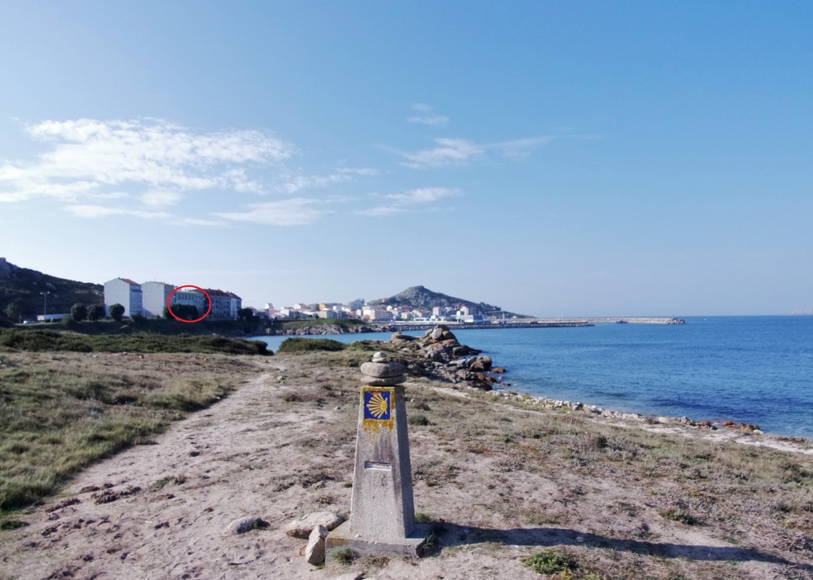
5:49 PM – Muxía: Camino marker post on
Praia de Espiñeirido near beginning of boardwalk; Muxía and Monte Corpiño –
from here, you can see Hostal La Cruz (see red circle) at the near end of town,
right on the water.

4:13 PM – Muxía: Muxía and Monte Corpiño
from Praia de Espiñeirido – MT had been here less than 2 hours earlier.
Don arrived in Muxía (pop 6,634) at 6 pm.
Muxía is
pronounced moo-chee-a in Galicia. The name derives from the congregation
of Benedictine monks (monxía in Galician), related to monks (monjes
in Spanish or monxes in Galician) of the monastery in nearby Moraime,
which was the principal focus of evangelization of the western coast of
Galicia. Already in the Middle Ages, Muxía was an important port to the Camino
de Santiago, according to the testimonies of pilgrims that came here.
Muxía is a coastal district in La
Coruna province on the Costa da Morte (coast of death) above Fisterra
(Finisterre). Contrary to popular belief, it is actually Muxía (Cabo Tourinan)
and not Finisterre that is the most westerly point of mainland Europe. Muxía is
a beautiful little town with some stunning beaches. It has a great manmade
harbor that is walled on two and a half of its sides. There is also a great
promenade, Paseo Maritimo, that runs the full length of the east side of town;
it begins at the south end of town on Avenida López Abente, which turns into
Rúa da Marina until reaching the marina, where Rúa da Marina continues and the
promenade splits off on the main coast-facing street of Rúa Virxe da Barca,
which leads past the Igrexa de Santa María and on out to Punta da Barca.
The city is still recovering from
a massive oil spill from the sinking of the oil tanker Prestige in November
2002, one of the biggest ecological and economic disasters in history. Muxía,
which was the population center of the Galician coast most affected by this
tragedy, still shows the black heritage of the oil spill.
At the end of the boardwalk, Don turned onto Avenida López Abente, the street along the water where Hostal La Cruz was located.

5:58 PM – Muxía: city limit sign on highway
where it joined Avenida López Abente.

MT 12:24 PM – Muxía: city limit sign on
highway where it joined Avenida López Abente – MT had taken this photo earlier
that day.

6:01 PM – Muxía: sign for “Costa da Morte” at
overlook (Miradoiro da Cruz) and smaller sign for A de Loló.
The foggy Costa da Morte [Coast of Death] in the northwest part of Galicia is
a jagged mix of cliffs and long estuaries that penetrate deep inland, and the
coast is a legendary wrecker of countless ships. This maritime carnage may
explain the name Costa da Morte (coast of death), but the coast may also be
named for the nightly death of the sun as it sets on Spain’s westernmost shore.
The sinking of the oil tanker
Prestige in 2002 caused the last and worst catastrophe on the Costa da Morte.
About 70,000 tons of crude oil spilled into the sea, contaminating the seabed,
and tens of thousands of sea birds perished. The effects could be felt as far
as Portugal and France. For Galicia, which lives mainly from the fishing and
shellfish industry, it was not only an ecological disaster, but also an
economic one from which the region is only slowly recovering.
Just as he entered town, Don saw Hostal La Cruz, where MT was waiting for him in the lobby between the bar and the restaurant. She had been expecting him earlier in the afternoon, apparently remembering his original plan for arriving there after splitting the route into 4 days. Don just was happy to have arrived—after walking 32.5 km in 10 hours.

6:01 PM – Muxía: entering actual town on Avenida
López Abente, with Hostal La Cruz (with blue sign) on left, Monte Corpiño at
end of street, and marina to right of railing of Paseo Maritimo.

6:01 PM – Muxía: Hostal La Cruz exterior –
with sign that still said “Pensión” and Restaurante.

Sunday, September 28, 2014, 11:14 AM – Muxía: Hostal La Cruz exterior –
with sign that still said “Pensión” and Restaurante (better light in morning) –
our room on “2nd” floor, with open curtains behind blue flag.

Sunday, September 28, 2014, 11:10 AM – Muxía: Hostal La Cruz - our room
(curtain closed).

Sunday, September 28, 2014, 11:10 AM – Muxía: Hostal La Cruz – our room,
view of bay from our window.

Sunday, September 28, 2014, 11:12 AM – Muxía: Hostal La Cruz – MT by window
in our room.

MT 6:08 PM – Muxía: Hostal La Cruz – Don in our
room just after arrival.

Sunday, September 28, 2014, 10:42 AM – Muxía: Hostal La Cruz – fire
evacuation instructions on back of our door.
As soon as Don showered, MT wanted him to try the great food in the La Cruz restaurant, where she had eaten several times before. We got the 12€ menu (we learned later that it was 15€ when you ordered the specialty encaldeirada de bacalao [in a stew of cod]: 1st course: both had caldo gallego; 2nd course: both had encaldeirada de bacalao; dessert: both had tarta helado (ice cream cake); bottle of red wine; lots of bread.

Monday, September 29, 2014, 10:16 AM – Muxía: Restaurante La Cruz:
blackboard with her specialties.

7:54 PM – Muxía: Restaurante La Cruz: platter
with our 2 servings of encaldeirada de bacalao
(cod with mussels, potatoes, and vegetables).

7:55 PM – Restaurante La Cruz: our bottle of
red wine “Viña do Val.”
No comments:
Post a Comment