
MT 8:07 AM – Triacastela: sunrise over Igrexa
de Santiago.

MT 8:08 AM – Triacastela: more of sunrise.
We
ate breakfast at Parrillada Xacobeo:
coffee/hot chocolate; 2 orange juice (natural); 2 tostadas con tomate y aciete and 3rd pan tostado con mermelade [toasted bread with marmalade] (8€
total). We got sellos “Complexo Xacobeo – Albergue – Pensión - Restaurante.” We
met 2 Italian girls at breakfast.
We
went back to Pensión Casa Simon, then departed at 8:05 am.
On
the way out of town, we passed Casa
David, where we had stayed last year.

8:13 AM – Triacastela: Casa David – front
part with café-bar.

8:13 AM – Triacastela: Casa David – part with
rooms and patios, around side.
From Triacastela to Sarria, the
Camino route descends another 230 m. There are two possible routes. One option is to follow the valley of río
Oribio which meanders to the southwest to the village of Samos, where many
pilgrims visit the Benedictine monastery, founded in the 6th century, and then
heads back north to join the more traditional route; this way is 25 km to
Sarria and is not as well waymarked.
The traditional, more direct
route is only 18 km to Sarria via San Xil; purists argue that this is the
original route. It follows multiple corredoiras
(paths through lush Galician forests, sometimes like tunnels through
low-hanging chestnut, oak, and birch trees and blackberry bushes), passes
through a number of picturesque villages, and includes a steep climb up to Alto
do Riocabo (910 m).
This Stage, despite being one of
the shortest (18.3 km), has a degree of difficulty due to the great ascent that
takes place in the first section, until reaching the peak of Riocabo. However,
the pilgrim enters in union with nature passing through beautiful and peaceful
indigenous forests and small villages lacking in commercial businesses. This
does have its disadvantage, as attempting to purchase a bottle of water at
certain times of year becomes a mission impossible.
We
chose the traditional, more direct route.
Around
8:38, we passed a hermitage. Unlike
last year, it was closed this time.
The hermitage is now occupied by a watercolor artist Englishman Arthur
who undertook the Camino in 2006 from St Jean Pied de Port. He chose the Samos
variant, although he gave in to the charm of this area and decided to settle
here in the fall of that year. With the help of a local mason, he reconstructed
the ruin of an old stone house into “a house for Jesus.” Many of his paintings
hang on the walls. The doors are usually wide open to pilgrims offering a place
to rest and pray. If his doors are closed, Arthur is probably on a trip to the
coast of Lugo.

8:38 AM – Before A Balsa: Hermitage, now
occupied by watercolor artist.
Around
8:40, we passed through A Balsa (pop
?, in the parish of San Breixo da Balsa, which had a population of 36 in 2013).
A
Balsa
[meaning The Ferry] is a diminutive village that has rejuvenated over the
years. It is one of the most picturesque villages on the Camino, a laidback
enclave of French influence.
Just north of it are the ruins of
Capilla de San Pedro do Ermo [Chapel
of St. Peter of Ermo], which is all that remains of an important
10th-12th-century monastery, which was founded by Count Gatón in the town of
San Pedro del Ermo.

8:40 AM –A Balsa – yellow arrows on stone
building (flat stone construction seemed typical of area); MT and other
pilgrims on street.
After A Balsa, the route begins
its ascent, climbing up abruptly along
the small valley of the Río Valdeoscuro [dark valley]. As its name suggests,
this stretch of the Camino is shaded by mature oaks and chestnut trees. The
difficulty of the climb may prevent pilgrims from fully enjoying the greenery
of the area, where oaks dominate. The path of earth and stones further
complicates the ascent.

8:43 AM – After A Balsa: MT and other
pilgrims on rocky woodland path.

8:47 AM – After A Balsa: MT with stone wall
and gate.
Just
before San Xil, the woodland path rejoined the asphalt road at a rest area with
a fountain with a large scallop shell motif, called Fonte dos Lameiros.

8:59 AM – Before San Xil: fountain with
scallop shell motif and reflecting pool (horizontal) with lady getting water.

8:59 AM – Before San Xil: fountain with
scallop shell motif and reflecting pool (vertical).
We
reached San Xil (pop 25) at 9:07.
The small town of San Xil was renovated in 2011, but does
not offer any place to purchase supplies.

9:07 AM – San Xil: MT entering town, with
city limit sign.

MT 9:07 AM – San Xil: MT
and city limit sign.

9:10 AM – San Xil: looking back over slate
roofs.
After San Xil, the Camino descends along a well-worn lane
enclosed by the dry stone walls that are a common sight along the route through
Galicia. Notice the grooves in the stone made from centuries of cart wheels
rolling by.
From
San Xil, we had a steep climb up by road to Alto do Riocabo, the highest point on that day’s stage.
Alto
do Riocabo
is the official Galician name of the mountain pass (905 m) between San Xil and
Montán. It is part of the Cordillera Cantábrica range.

9:38 AM – After San Xil: MT at intersection,
deciding whether to follow the pilgrim ahead of us; there was a yellow arrow
painted on a flat stone in the path.

9:38 AM – After San Xil: yellow arrow
painted on flat stone in path at intersection.

9:57 AM – After San Xil: Small building made
of flat stones, with old wood fence.

9:57 AM – After San Xil: MT starting on
wooded path; yellow arrow on Camino marker stone at right.

9:58 AM – After San Xil: flat stone wall
beside path.

10:00 AM – After San Xil: flat stone wall
with heather (when we stopped to put on rain gear at 10 am).

10:04 AM – After San Xil: coke machine in
middle of nowhere; posts with yellow arrows (pointing to path between them, not
to the Coke machine); MT starting down wooded path with high banks on sides.
After
Alto do Riocabo, we left the road onto a forest track, sometimes on stone
slabs, with high banks on sides.
From Alto do Riocabo [peak of Riocabo], there is a long and sometimes
steep descent to Sarria. Pilgrims enter the Medorra Mountains, where they can
enjoy the natural vegetation of fine oaks and birches.

10:05 AM – After San Xil: MT (in rain gear)
on stone path with high banks and trees.

10:05 AM – After San Xil: MT passing marker
post on stone path with high banks and trees.
The
corredoira (wooded path) descends to Montán and Fontearcuda.
The descent into Montán (pop ?) is dangerous because the path is made up of stone slabs.
The village of Montán has 13 households. The Igrexa de
Santa María has a Romanesque nave.
Around
10:10, we passed through the hamlet of Fontearcuda
(pop ?).
Fontearcuda is a village of
3 houses. It received its name from a precious fountain that provided solace
for pilgrims and never ran dry. The Camino marker post here shows only 121.5 km
to Santiago.

10:11 AM - (Probably) Fontearcuda: narrow
street between buildings made of flat stone (we weren’t sure this was the way,
but there was a pilgrim at the far end by what turned out to be a yellow arrow
for the next turn).

10:11 AM (Cropped) - (Probably)
Fontearcuda: narrow street between buildings made of flat stone - yellow arrow
for turn at the far end (in red circle).
After Fontearcuda, dense patches of oak and chestnut trees give way to meadows.

10:28 AM – Near Mondaviega: French pilgrims
at top of steep downhill path off a brief stretch of paved road, by 121 km
“Mondaviega” marker stone.

10:45 AM – Near Furela: 120 km marker stone,
another marker stone with yellow arrow; in background are fields with stone
walls.
The Camino rejoined the asphalt road into Furela.
We
arrived in Furela (pop ?) around
10:45 am.

1:047 AM - Furela: entering (not much of a)
town, city limit sign.
The hamlet of Furela (or A Furela) is the border between the concellos (municipalities) of Samos and Sarria. The emblazoned
houses stand out among the rest of the houses. However, the Camino actually
goes around the village, which has absolutely no services for pilgrims except
for a sign with the phone number of a taxi driver.
A few meters after leaving
Furela, there is a sign indicating the route is entering the Concello de Sarria. After A Fuerla oak
and chestnut trees give way to meadows.
We
stopped at Casa do Franco, a popular
café-bar where we had also stopped last year, for 2 pinchos de tortilla (5€
total). While there, we met the 2 ladies from Colombia. All morning, we walked
in light rain.

11:13 AM - Furela: Casa do Franco – bar,
with shelter house to left; yellow arrow on pavement to left of steps.

MT 11:15 AM - Furela: Casa do Franco –
Colombian ladies at bar.

11:14 AM - Furela: Casa do Franco – outdoor
table and shelter house.

2085
Thursday, September 18, 2014, 1052 AM - Furela: Casa do Franco – “Miri war
hier” [German for “Miri was here” ] written on back of bench at outdoor table (Don
had remembered seeing it there last year and quickly found it was still there); Miri is allso a nickname for our daughter
Miriam.

MT 11:11 AM - Furela: Casa
do Franco – when MT came out with our food, Don showed her the “Miri war hier.”

10:57 AM - Furela: Casa do Franco – view from
inside the shelter house, where we ate.
After
Furela, we continued on a path with flat-stone walls on both sides.
At the end of Furela, the path
follows the highway; this area is called Brea, which means “verada, ruta”
[path, road]. This begins the descent into the lush valley of Sarria.

11:31 AM – After Furela: yellow arrow on
flat-stone wall.

11:32 AM – After Furela: MT on path between
flat-stone walls.

11:41 AM – After Furela: MT on path with low
stone wall – first view of Sarria at 11:41 am.
Around
11:45, we passed through village that may have been Pintín (pop 58).

11:46 AM – (Pintín): MT turning corner; just
to her left are Camino shell marker and yellow arrow.

11L46 AM (Cropped) – (Pintín): MT turning
corner; just to her left are Camino shell marker and yellow arrow, both
pointing to turn right.
Around Pintín, the descent
becomes more pronounced. On leaving the town, there is a comfortable road with
little traffic. However, the route soon veers away from the highway again, onto
a very steep, wooded slope, on uneven terrain.

12:01 PM – After (Pintín?): old trees along
(and over) path.
We
passed through Calvor and Aguiada, two places where pilgrims from
the alternate route via Samos rejoins the traditional route.
Calvor occupies the
site of the pre-Roman hill fort Castro
Astorica. The town’s original medieval name was Villa del Calvario [Town of
Calvary]. In the 7th century, a monastery dedicated to San Pablo y San Esteban
[St. Paul and St. Stephen] was founded in the town. Its Egreija de San Esteban
[Church of St. Stephen] was founded in 785, and its earliest parts are
Visigothic, although there are almost no traces of the Romanesque building and what
remains today is mostly from the 18th or 19th century. Inside, an alabaster
Visigothic capital from the monastery now serves as a baptismal font.
Between Calvor and Sarria, the route
runs parallel to the road, leaving only to go through the village of Aguiada.
Just a few hundred meters west of Calvor
is Aguiada, a small town that once
had several pilgrim hospitals. The westernmost house (on the left) in the hamlet
is still known locally as “Hospital.” (According to Brierley, Hospital is a
separate hamlet farther west.)
We
arrived in Sarria (pop 13,000) at 1
pm.

12:56 PM – Sarria: entering town (before Vigo
de Sarria) – welcome sign and soft drink machine.
Sarria is the capital
of a comarca (region) of the same
name. It is in an area that has been populated for thousands of years, as
megalithic graves uncovered here reveal, although it is difficult to establish
who the first settlers were. There are several archaeological sites and remains
of castros (hill-forts) in the area.
We know that it was inhabited both by the Celts and the Romans. The Roman
presence in Sarria is linked to the nearby Roman city of Lucus Augusti (Lugo), which connected the villa sarriana with Castro Dactonio (Monforte de Lemos, 34 km
south-southwest of present Sarria]); archaeological excavations have revealed
the presence of two Roman villas located in Vilar de Sarria [(now a suburb just
east of Sarria] and San Antolín [about 7 km northeast of Sarria]. There was a Sarrianese
County (condado, ruled by a count)
during the Swabian rule of Galicia (the rest of the current comarca of Sarria belonged to the
Parmanese County). The Muslim conquest was limited and left few traces in
architecture or place names. The only evidence of this period is that there was
a repopulation of the County of Sarria. Sarria is known to have been repopulated
in 750 by Odoario, Bishop of Lugo. In 785, a monastery was founded “in the
historic village.” In the early 12th century, the name “Comes in Sarria”
appeared connected to these lands. However, the main history of this
municipality began with the first pilgrimages to Santiago by the Camino
Francés.
In the late 12th century, Alfonso
IX (1171-1230), the king of Galicia and León, established Vilanova de Sarriá [new town of Sarria, implying there was an older
town] as a “villa real” [royal villa]. The king would die there in 1230. The
structure of the town was completed in 1280, as were two churches (San Salvador
and Santa Mariña) and a monastery (la Magdalena).
Sarria was a major medieval
center for pilgrims on the Camino de Santiago, giving rise to hospitals,
chapels, monasteries, bridges, and inns and attracted institutions to care for
pilgrims (the “Madalenos” in Sarria). The old quarter climbs along the Rúa Mayor
(main street) past Igrexa de Santa María, with its pilgrim mural up to the
ruined castle Fortaleza de Sarria at
the top. The decline of pilgrimages to Santiago brought a long period of
decline for the town. By the 18th century, there were only 70 houses and a few
shops in the village, and Sarria was mostly a rural municipality. In the 19th
century, the town center gravitated eastward, leaving the ancient camino real largely intact. Most of the
city was built in the 19th and 20th centuries.
Today, Sarria is a popular
starting point where many pilgrims begin their Camino, since it is only 5 days
and a little over 100 km to Santiago, meeting the minimum requirement for
receiving a Compostela certificate for those traveling on foot (or horseback).
This is what some would call a “Camino-lite or the “tourist leg.”
As
we crossed the Río Sarria into the old quarter, there were detours around
construction for rebuilding the bridge.
We
went to Hotel Oca Villa de Sarria
(3-star), where we had stayed last year, and got a double room for 55€
including buffet breakfast. The receptionist suggested using a mochila (backpack) transport service.
When we explained that we didn’t have reservations for placed to send the bags
to, she offered to make reservations for us. We went over Don’s “Possible
Lodging” list and gave her our best choices for the next 5 nights. She said she
would call them from home, after she got off work. For 30€, she would book our
luggage transfer to these places.

7:07 PM – Sarria: Hotel Oca de Sarria -
exterior.

2:19 PM – Sarria: Hotel Oca de Sarria – our
room (No. 502).

2:20 PM – Sarria: Hotel Oca de Sarria - our
room (No. 502).

2:20 PM – Sarria: Hotel Oca de Sarria – view
from our room toward the Río Sarria and Ochanto restaurant on right.
For
lunch, we passed on Ochanto, where we ate last year, but tried another place on
the near side of the river (Río Sarria). Mesón
Roberto had a 9€ menu for lunch: 1st course: both had caldo gallego; 2nd course: both had merluza a la plancha [grilled hake] with salad vice fries; dessert:
Don tarta de helado (same as last
night in Triacastela, minus the caramel sauce)/MT asked for cheese (Arzúa) with
marmalade (blackberry); wine. We met the 2
ladies from Colorado at Mesón Roberto.

4:01 PM – Sarria: Mesón Roberto (with orange
backpack in door) and other restaurants and bars on Rúa Malecón promenade (Paseo
do Malecón) on W side of river.

6:39 PM – Sarria: Mesón Roberto - 9€ menú del
día.
At
6:15, Don went out to see the town, in a light
rain, and bought some fruit and then 4 yogurts (1.30€).

6:29 PM – Sarria: “getting all your ducks in a row” on the río
Sarria near Mesón Roberto.

6:40 PM – Sarria: old bridge over río Sarria
under repair; Paseo do Malecón on right bank.
The 12th-century Ponte Ribeira bridge on the Rúa do
Peregrino [pilgrim street] spans the Río Sarria. This is one of four medieval
bridges of the town that, together, were declared a Bien de Interes Cultural (BIC) in 2011. The bridge was part of a
major channelizing project in 2014. The project included involved destroying
arches of the bridge dating from the 17th century and moving the abutment of
the bridge outward a few meters to solve problems of flooding in the area. In
October 2014, however, the courts declared a stoppage of the work on this
bridge, considering this an offense against its historical character and
claiming that a continuation of the work could lead to the irreversible destruction
of its historical and cultural value. This left the bridge cut for months, into
2015.
Because of the construction, we had to take a detour off to the north around the Ponte Ribeira to get from the Rúa de Peregrino to the Paso de Malecón (or vice versa).
West
of the bridge, a large staircase, Escalinata
Mayor, leads up to the Rúa Mayor [main street] in the higher part of the
town.

6:42 PM – Sarria: steps to Rúa Mayor and Igrexa
de Santa Mariña; yellow arrow at left points to the entrance of a pensión.
The Escalinata Mayor [Main Staircase] (previously called Escaleira da Fonte [Galician: Staircase of the Bridge]), from the
19th century, leads up to the old town, which retains a strong medieval
character, with its noble houses of granite masonry.
At
the top of the steps was the Igrexa de
Santa Mariña.

6:45 PM – Sarria: Santa Mariña – tower and S
side with pilgrim mural.
The 19th-century Igrexa de Santa Mariña [Church of St.
Mariña, a Galician martyr] was built over the ruins of the previous Romanesque
church of the 13th century, which was dedicated to San Xoán, patron of the city.
The new church was inaugurated in 1885. It is situated on the Rúa Mayor, next
to the ancient Plaza del Mercado, where Sunday markets were held until 1950 (it
is now called Plaza de Juan María Lopez). It has a distinctive pyramid-style tower, capitelada [capitaled, with capitals on
the corners], that contains a clock. A mural on a side wall depicts
pilgrims making their way to the church.

6:45 PM – Sarria: Santa Mariña façade and
entrance.
Don
continued west on Rúa Mayor into the
old town, where several places had wood-carved signs.
The Rúa Mayor was the main street until the city began to expand eastward
in 1860.

6:46 PM – Sarria: Albergue Internacional wood-carved
sign for “Albergue” – Santiago Apostol relief.

6:46 PM. – Sarria: Albergue Internacional wood-carved
sign for “Restaurante” and “Shelter – Albergue” – Santiago Peregrino (and small
figure of Santiago on the outside edge).

6:47 PM. – Sarria: Albergue Obradoiro wood-carved
sign with main façade of Santiago cathedral (on Praza do Obradoiro) and small
figure of Santiago on outside edge (www.arte-san.es was URL for
Asociación Galega de Artesans, now www.galegadeartesans.org talla y
escultura en madera [carvings and sculpture in wood]).

6:47 PM – Sarria: Albergue Obradoiro –
another sign, by door, with Santiago Peregrino and “ASC Artesanos Camino de
Santiago ‘ARTE-SAN’ Talla y Escultura” [ASC Artesans Camino de Santiago
“ARTE-SAN” Carvings and Sculpture].

6:49 PM – Sarria: carved wood sign – wood-carved
Santiago with 8€ menú del día for Mesón O Tapas.

6:49 PM – Sarria: another wood-carved sign
for Mesón “O Tapas” with men at bar.
In
Praza da Constitución [Constitution Square], off Rúa Mayor [Main Street] to
left, there was a statue of King Alfonso
IX

6:50 PM – Sarria: statue of Alfonso IX.
Alfonso
IX,
King of León and Galicia (1171-1230, ruled 1188-1230), established the city as
the villa real [royal town] Vilanova
de Sarria in the late 12th century. He died here in 1230, of a serious illness
while making another pilgrimage to Santiago in thanksgiving for the reconquest
of Mérida. He is buried in the Cathedral of Santiago de Compostela.

6:50 PM – Sarria: statue of Alfonso IX with
delivery truck; plaque: “Os Sarriaos ad seu Fundador Alfonso IX Rei de León e
Galicia †Vilanova de Sarria, 24-IX-1230” [The people of Sarria to their founder
Alfonso IX King of León and Galicia died Vilanova de Sarria, 24 September 1230].
The
miniature staircase to the right of
his foot is a model of the external staircase that leads to the top of the
tower of the Fortaleza de Sarria, where King Alfonso IX died in 1230; if you look closely, the tower is there too.
Past
that, at the end of Rúa Mayor, was Igrexa
de San Salvador.
6:53 PM– Sarria: Igrexa de San Salvador –
façade and belfry.
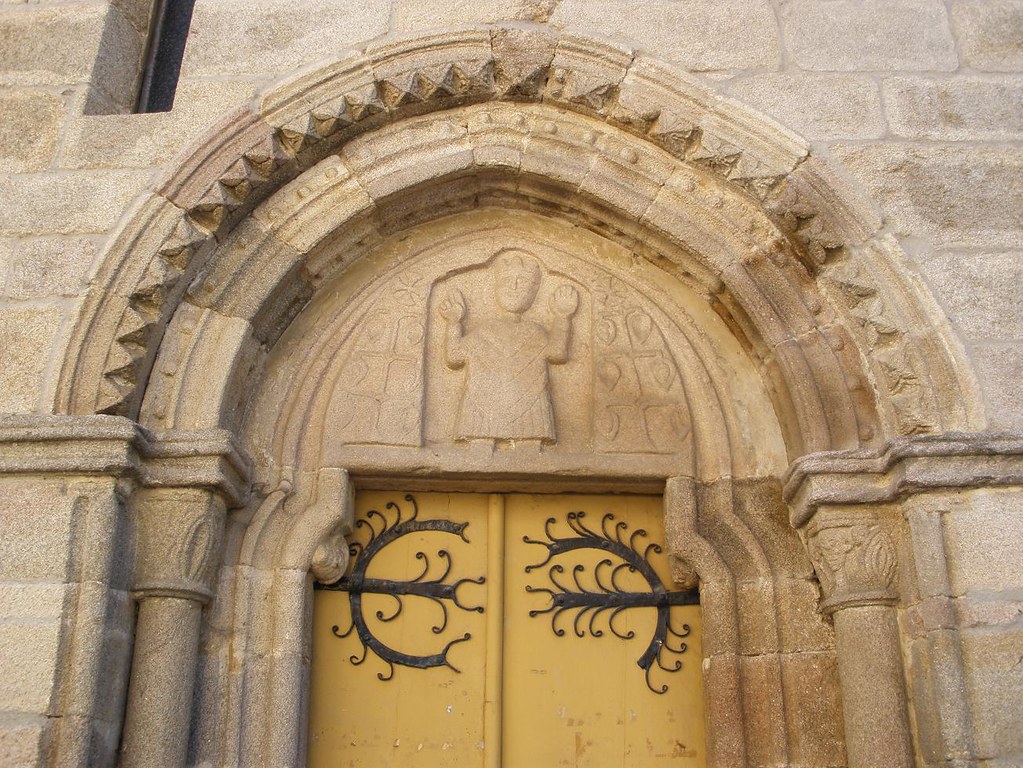
The mainly 13th-century Igrexa de San Salvador belongs to the transition
from late Romanesque to primitive (early) Gothic. It has a semicircular apse
and a Romanesque tympanum over the Gothic main door. The late Romanesque north
side door has two somewhat pointed archivolts and a tympanum with a bas-relief
of a Pantocrator [Christ in His Majesty], simplified in an archaic touch, and
other mysterious iconography; to the sides of the Pantocrator are two very
geometricized trees crowned by Greek crosses (crosses inscribed in circles),
possibly representing the symbolic tree of life; the hardware of the door
appears to be from the original period. The belfry was a later addition (1860)
in the Baroque style.

Sarria: Igrexa de San
Salvador - apse (commons.wikimedia.com at https://upload.wikimedia.org/wikipedia/commons/9/9f/Igrexa_de_San_Salvador_de_Sarria_1.jpg).

Sarria: Igrexa de San
Salvador - north door (commons.wikimedia.org at https://upload.wikimedia.org/wikipedia/commons/b/b8/Portada_setentrional_igrexa_de_San_Salvador_de_Sarria.jpg).

Sarria: Igrexa de San Salvador
- north door tympanum (www.flickr.com at https://c2.staticflickr.com/6/5052/5390025034_50d54866f4_b.jpg Cropped).
This church was mentioned in
1094, and it was included in a papal bull of 1332 giving indulgences to those
who cared for pilgrims. Facing this church, is the former Hospital de San
Antonio, founded in 1588 and operating until 1845 to serve pilgrims returning
from Santiago. It later served as city hall, school, and prison and is now the
courthouse.
Past
that were the ruins of the 13th-century Fortaleza
de Sarria.

6:52 PM – Sarria: Fortaleza de Sarria –
tower and ruins (rain spot on lens); yellow arrow indicated the Camino turns
right.

6:56 PM – Sarria: Fortaleza de Sarria –
tower and ruins (from other side, rain spots on lens).
The Fortaleza de Sarria, at the highest point in the city, dates from
the 12th century. It was built on the site of an ancient castro (hill fort) on a hill from which much of Sarria is now
visible. Of the original fortress, only one of the 4 towers (some sources say
there were 6) remains. Called Torre de Sarria or Torre de la Fortaleza, it is
crenellated (with battlements at the top), 15 m tall, and built of masonry
(granite stones and slabs). The rest was destroyed in 1467 during an uprising
of the peasantry against the aristocracy known as the Irmandiños.* The castle was rebuilt in the 15th century and was
lived in until 1730, but by the late 18th century it was again in a ruined
state. In 1860, the City Council purchased the castle and dismantled it under
the banner of civic progress; its stones were used to pave the town’s streets,
and many of the stones and the other towers were sold off to the townspeople. The
moat was also filled in the 19th century. Since 1860, the remaining tower has belonged
to the Pérez-Batallón family (therefore also known as Torre do Batallón), and
entrance is not permitted. As of October 2015, the property, including the
tower, the owners’ main house (attached), a palomar
(dovecote), part of the tower moat, and another house, was for sale at
€750,000, lowered from €1.1 million. The City Council has tried several times
to buy it back, but is unwilling to pay the asking price. The tower was
declared a Bien de Interés Cultural
(BIC) in 1994, and the city is concerned that someone will have to repair a
large crack that has developed in the north side and a part of the wall that
collapsed in 2013.

Sarria: Fortaleza de
Sarria – tower and remains of outer wall before collapse (es.wikipedia.org).
* Irmandiños: On the death of Alfonso IX in 1230, his son Fernando
III of Castile, king of Galicia and Portugal, was proclaimed king of León, and
he subsequently neglected Galicia, which fell into a period of decline. Among
the nobility and members of the Galician administration, Castilian became the
dominant language. After the death of King Enrique IV, there was a dispute
about succession, which gave rise to new expectations of liberation among the
Galician nobles, who supported the future Queen Isabella in the dispute with
Juana (la Beltraneja). Thus, in the 15th century, parallel to the rebellion of
the League of Nobles in Castile, a movement developed in Galicia, known as the
revolt of the Irmandiños (after the 14th-century conflicts between the monarchy
an the archbishop of Santiago, called an “Irmandade”). Tensions in the 15th
century led to the Irmandiñas wars: the first called “Irmandade Fusquenilla”
(1431) and the second called the “Gran Guerra Irmandiña” [Great Irmandiña War]
(1467-1469). The second was configured like a real civil war, with an army of
over 50,000 men who ravaged about 130 fortresses. The Irmandiño movement could
only be put down with a united mobility headed by Pedro Madruga. The process of
dismantling the Galician institutions occurred during the reign of Ferdinand
and Isabella, who imposed their justice and punished the nobles, such as Pedro
Madruga, who had declared against Isabella in the succession struggle, tore
down their strongholds, and forced them to leave Galicia.
Near
the fortress is a mirador [overlook]
with a modern cruceiro [crucifix on a column].

7:00 PM – Sarria: modern cruceiro
overlooking city.
Don
came back to the hotel at 7:15 to take MT to the 7:30 mass at Igrexa de Santa Mariña, but we found
the mass had actually started at 7:15 (an exception, explained the man who gave
us sellos after mass).

8:05 PM – Sarria: conch shell pattern of
stones in sidewalk on Malecón promenade.
After
mass, we tried another store for gazpacho in carton; finding none, we settled
for 2 LARGE sangrias in Bar Burillo (4.40€ total).

8:24 PM – Sarria: Bar Burillo – MT with
large sangrias.

MT 8:57 PM – Sarria: Hotel Oca Villa de
Sarria – view to E toward Río Sarria from our window.
No comments:
Post a Comment