We
ate the breakfast buffet (included) at Hotel
Vigo Plaza. Then we went to the 9 am mass at Iglesia de Santa María
Auxiliadora and talked briefly with the Salesian priest after mass. He said
that the man in a modern suit depicted on the main altar was Domingo Savio, a
friend of Don Bosco.
Then
we went back to Hotel Vigo Plaza to pay our bill and leave our backpacks at the
desk to pick up after our trip to the Cíes Islands.
On
our way to the port, we passed a pastelería
(pastry shop) with decorated cakes in the window, including some decorated as
purses.

9:50 AM – Vigo: pastry shop on way to port – cakes decorated as handbags.
We arrived at the port around 10 am. Near the dock for travel in the
estuary (Estación Maritíma de Ría), we saw part of the series of huge bronze
sculptures called El Nadador (The Swimmer).


Vigo: El Salto (The Jump) portion of El Nadador
sculpture by dock for travel in the estuary (Estación Maritima de Ría) (www.flickr.com at https://www.flickr.com/photos/alugueirolares/3833785385).
One of the most iconic sculptures
in Vigo is El Nadador (The Swimmer).
Located on the edge of the Vigo estuary, it consists of several bronze elements
that seem partially submerged in the pavement of Vigo’s port rea. The main
figure, El Salto (The Jump), is located in As Avenidas, next to the Ría
Maritime Station. The second sculpture is in the Praza da Estrela square and
represents the swimmer already in the water, his bronze face a reflection of
his efforts; he is about to plunge his arm in a perfect front crawl stroke. A
third sculpture (also located in the port area, not far from Gran Cerveceria El
Puerto) is the Swimmer’s Arm, ten times life size, rising out of the pavement
in a swimming stroke.

9:58 AM – Vigo: El Salto (The Jump) portion of
El Nadador sculpture by dock for travel in the estuary (Estación Maritima de
Ría).

Vigo: El Salto sculpture (close up) (www.flickr.com
at https://www.flickr.com/photos/alugueirolares/3833784685) .

MT 9:57 AM – Vigo: Don with head of El Salto.

MT 9:58 AM – Vigo: MT with head of El Salto.

Vigo: El Nadador swimmer in water
(commons.wikimedia.org).
At
the port, we saw some large ocean liners/cruise ships (not the same as the day
before) docked at the Estación Maritíma de Transatlanticos.

10:01 AM – Vigo: Estación Maritíma de
Transatlanticos – ship MSC Opera.

10:02 AM – Vigo: Estación Maritíma de
Transatlanticos – another transatlantic ship (left, with name hidden by station)
and MSC Opera (on right).

10:02 AM – Vigo: Estación Maritíma de
Transatlanticos – the second ship and the station (telephoto, 64 mm).
Since
we had time to kill, we went into the information
center, where we saw a display about the formation of the Ría (estuary).

10:14 AM – Vigo: information center – sign in
Galego, Spanish, and English about “Origin and Formation of the Ría – Vigo’s
ría was born of the passion between the land and the sea.”

10:15 AM – Vigo: information center – sign
about “Origin and Formation of the Ría”; close-up of diagrams with captions:
“1. Over 100 Million Years Ago.”
“2. 10,000 Years Ago” showing Río
Verdugo river at top of the valley, from which glacial melt-off began to flood
the valley.
“3. Present” showing the city of
Vigo on the south side of the estuary and the Cíes Archipelago, which was
originally a mountain ridge to the west.
Text on left side of sign in Galego, Spanish, and English about “Origin and Formation of the Ría” keyed to diagrams; English text [corrected from the Spanish]:
“1. A series of movements of the Earth’s crust, spanning the course of millions of years, were responsible for shaping and moulding the Atlantic’s fluvial valleys and caused their subsequent subsidence [sinking].”
“2. More than 10,000 years ago, the sea levels rose as a result of melt water from the last glaciation, flooding the V-shaped fluvial valley, now Vigo’s ría.”
“3. The dunes and beaches are made of materials brought by the sea, washed up on the coast and moved by the wind. Their material originates from biological remains—mostly shells and carapaces from sea life—as well as particles of rock—granites, gneisses and schists—ground down by the force of the sea, the sun and the wind. The Verdugo river drags the sediments that create the marshes at the end of the ría to its mouth [at the mouth of the ría].”
Around 10:30, we saw our boat, Pirata de Cíes, which was to depart from Pier No. 3 at 11 am. A sign said boarding was at 10:45, but our boat went away and didn’t come back until just before 11 am.

10:31 AM – Vigo: MSC Opera liner behind our
cruise boat Pirata de Cíes.

10:54 AM – Vigo: our cruise boat Pirata de
Cíes (before it went away from the pier).

MT 11:00 AM – Vigo: MT on Pirata de Cíes with
MSC Opera in background.

11:02 AM – Vigo: MSC Opera from our departing
cruise boat.

11:02 AM – Vigo: MSC Opera and other liner at
Estación Maritíma de Transatlanticos, from departing cruise boat.

MT 11:04 AM – Ría de Vigo: Don on cruise boat
as we left the port.

MT 11:08 AM – Ría de Vigo: Don on cruise boat
with view toward Cíes Islands in distance.

11:14 AM – Ría de Vigo: view back to marina
and Vigo.
We made a stop at a town across the bay (Cangas) on the way to the islands, but not on the way back.

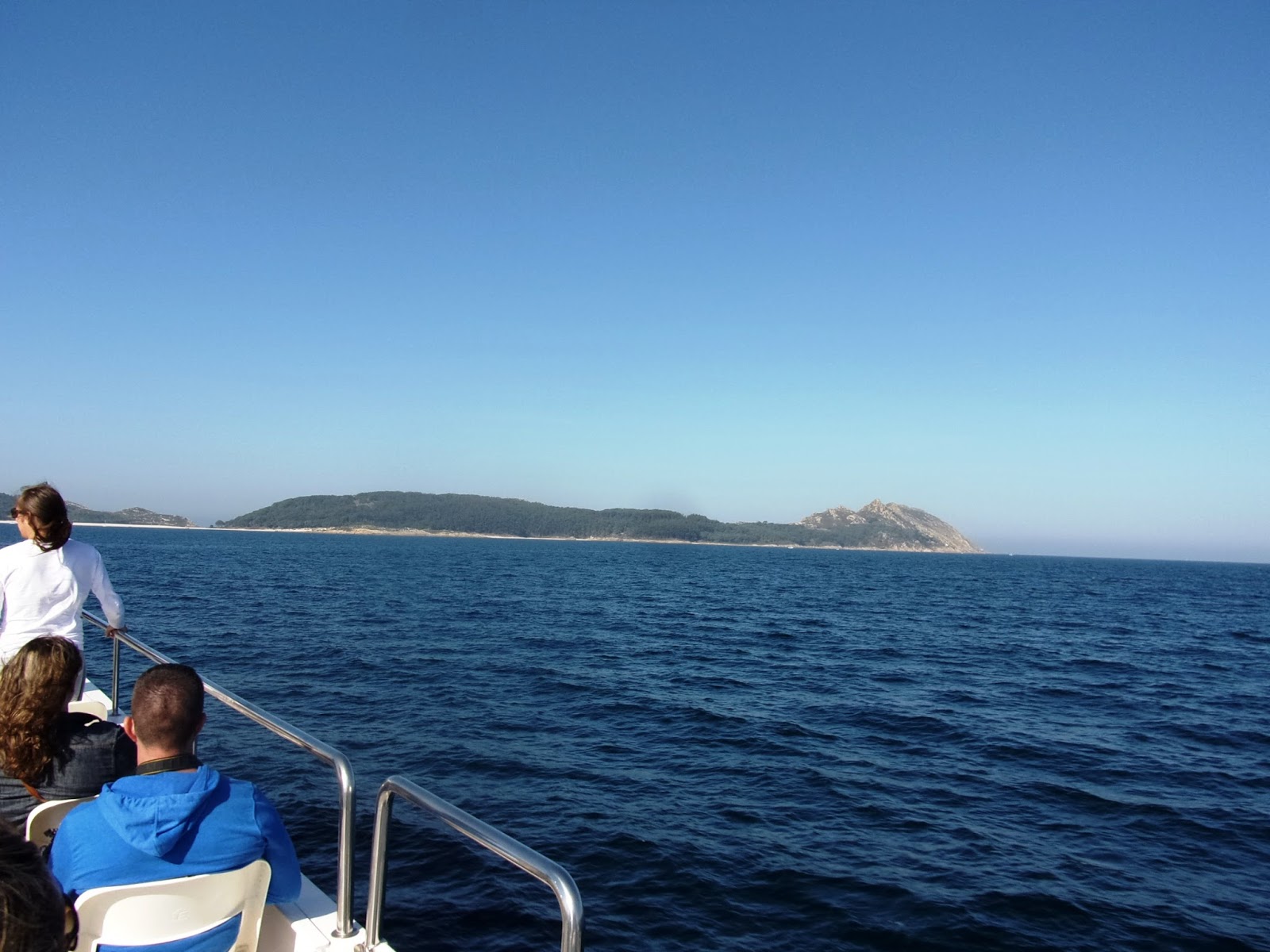
11:34 AM – Cíes: view toward islands: South
Island or Illa de San Martiño (at far left), Middle Island or Illa do Faro,
North Island or Illa de Monteagudo.
For orientation, the following map shows the islands of the Cies archipelago (with their Galego names). It also shows the possible routes one can take when exploring the islands. Given time constraints, we chose Route 1 (to the lighthouse on Monte Faro).

Cies Archipelago Map (Scanned).
The islands, called Cíes Illas in Galego (Islas Cíes in Spanish, Cíes Islands) are an archipelago in the mouth of the Ría de Vigo. At the end of the Tertiary geologic period, about 2.5 million years ago, some parts of the coast sank, creating rías (estuaries). The peaks of the coastal mountains once joined to the mountain ridges of the coast and now isolated by coastal flooding, comprise a chain of islands that protects the Ría de Vigo estuary. The Cíes archipelago consists of three islands, beginning in the south with Illa de San Martiño ("Saint Martin" or Illa do Sur, “South Island”) and continuing with the islands of Monte Faro (Illa do Faro or Illa do Montefaro, "Lighthouse Island", or Illa do Medio, "Middle Island") and Monte Agudo (Illa do Monteagudo, "Sharp Mount" or Illa do Norte, “North Island”), both of which are joined by the a 1,200 m long sandbar known as Praia de Rodas (Rhodes Beach). During high tide, the sea flows between the islands from the west side and, blocked by the beach, it fills the lagoon between the sandy area and the rocks. The western face of the islands, looking out over the sea is more abrupt, with sharp slopes that form cliffs. The eastern face, overlooking the estuary is less steep, covered by woods and bushes, and protected from the Atlantic winds, allowing beaches and dunes to form. In 2007, the British Newspaper The Guardian chose the beach of Rodas as “the best beach in the world.”

MT Wednesday, October 01, 2014, 1142 AM – Cíes: MT on cruise boat; Middle
Island or Illa do Faro; North Island or Illa do Monteagudo in background.
11:43 AM – Cíes: a bit of Middle Island or
Illa do Faro; North Island or Illa do Monteagudo.

11:43 AM – Cíes: top deck of cruise boat; 3
islands in background.

11:43 AM – Cíes: top deck of cruise boat (MT seated
by rail on left); Middle Island or Illa do Faro in background.

11:44 AM – Cíes: Middle Island or Illa do
Faro; a bit of North Island or Illa do Monteagudo.

1145 AM – Cíes: a bit of South Island or
Illa de San Martiño (at far right); Middle Island or Illa do Faro (Faro de Cíes
lighthouse up on Monte Faro and white beach below).

11:47 AM – Cíes: South Island or Illa de San
Martiño (at right), Middle Island or Illa do Faro (with white beach).

11:47 AM – Cíes: a bit of South Island or
Illa de San Martiño (at far right), Middle Island or Illa do Faro (with white
beach).

11:48 AM – Cíes: white beach connecting
Middle Island or Illa do Faro and North Island or Illa do Monteagudo.

11:50 AM – Cíes: white beach Praia das Rodas
connecting Middle Island or Illa do Faro and North Island or Illa do Monteagudo.

11:50 AM – Cíes: Praia das Rodas beach;
greenish water was shallower.

11:50 AM – Cíes: part of Middle Island or Illa
do Faro and Praia das Rodas beach.
We landed at the dock (Peirao de Rodas [Pier of Rhodes]) at the north end of Praia das Rodas just before noon.
The islands, called Cíes Illas in Galego (Islas Cíes in
Spanish, Cíes Islands) are an archipelago in the mouth of the Ría de Vigo. At
the end of the Tertiary geologic period, about 2.5 million years ago, some
parts of the coast sank, creating rías
(estuaries). The peaks of the coastal mountains once joined to the mountain ridges
of the coast and now isolated by coastal flooding, comprise a chain of islands
that protects the Ría de Vigo estuary. The Cíes archipelago consists of three
islands, beginning in the south with Illa de San Martiño ("Saint
Martin" or Illa do Sur, “South Island”) and continuing with the islands of
Monte Faro (Illa do Faro or Illa do Montefaro, "Lighthouse Island",
or Illa do Medio, "Middle Island") and Monte Agudo (Illa do
Monteagudo, "Sharp Mount" or Illa do Norte, “North Island”), both of
which are joined by the a 1,200 m long sandbar known as Praia de Rodas (Rhodes
Beach). During high tide, the sea flows between the islands from the west side
and, blocked by the beach, it fills the lagoon between the sandy area and the rocks.
The western face of the islands, looking out over the sea is more abrupt, with
sharp slopes that form cliffs. The eastern face, overlooking the estuary is
less steep, covered by woods and bushes, and protected from the Atlantic winds,
allowing beaches and dunes to form. In 2007, the British Newspaper The Guardian chose the beach of Rodas as
“the best beach in the world.”
XXX


11:57 AM – Cíes: Pirata de Cíes cruise boat
docked at north end of Praia das Rodas.

MT 11:57 AM – Cíes: MT and Don on dock;
boardwalk toward information booth and Illa do Faro in background.

MT 11:57 AM – Cíes: MT and Don on dock; Praia
de Rodas beach and Monte Faro in background.

MT 12:01 PM – Cíes: Don on boardwalk; Praia de
Rodas beach and Monte Faro (left) and part of Illa do Monteagudo (right) in
background.

MT 12:01 PM – Cíes: MT on boardwalk; Praia de
Rodas beach and Monte Faro (left) and part of Illa do Monteagudo (right) in
background.

12:15 PM – Cíes: other boat passengers heading
for bridge between Illa do Faro (left) and Illa do Monteagudo, with Lago
(lagoon) to east/left of bridge.

12:17 PM – Cíes: rocks above and mostly below
water in Ensenada do Lago [bay of the lagoon] to west of bridge at high tide.

2:47 PM – Cíes: same rocks above water in Ensenada
do Lago to west of bridge at low tide.
On
Cíes, we had a choice of four routes to take, two to the south: Monte Faro (7.4
km, 2h 30 min round trip) or Faro da Porta (5.2 km, 1h 45 min); two to the
north: Alto do Principe (3 km, 1h 15 min) or Monteagudo (5.6 km, 1h 45 min). The
girl at the information booth 100 m from the dock on Illa do Monteagudo gave us
a better map and said that the Monte Faro route was the best view. So we
decided to go that way to Faro do Cíes, although this was the longest and
steepest of the routes. She also told us we should take the detour (about 5
minutes) to the Pedra da Campá (Stone of the Bell) viewpoint (which we did)
and, on the way back from the Faro (lighthouse) we could take the cross-over
path to Faro da Porta (which we decided not to do).
We started up the path to the south around 12:30.

12:29 PM – Cíes: view back across lagoon to
Illa do Monteagudo and Praia de Rodas beach, from path to Faro do Cíes.
12:38 PM – Cíes: MT starting up path to right
toward Faro do Cíes and Pedra da Campá; the lower path to the left led to Faro
da Porta, closer to the eastern side (see sign).
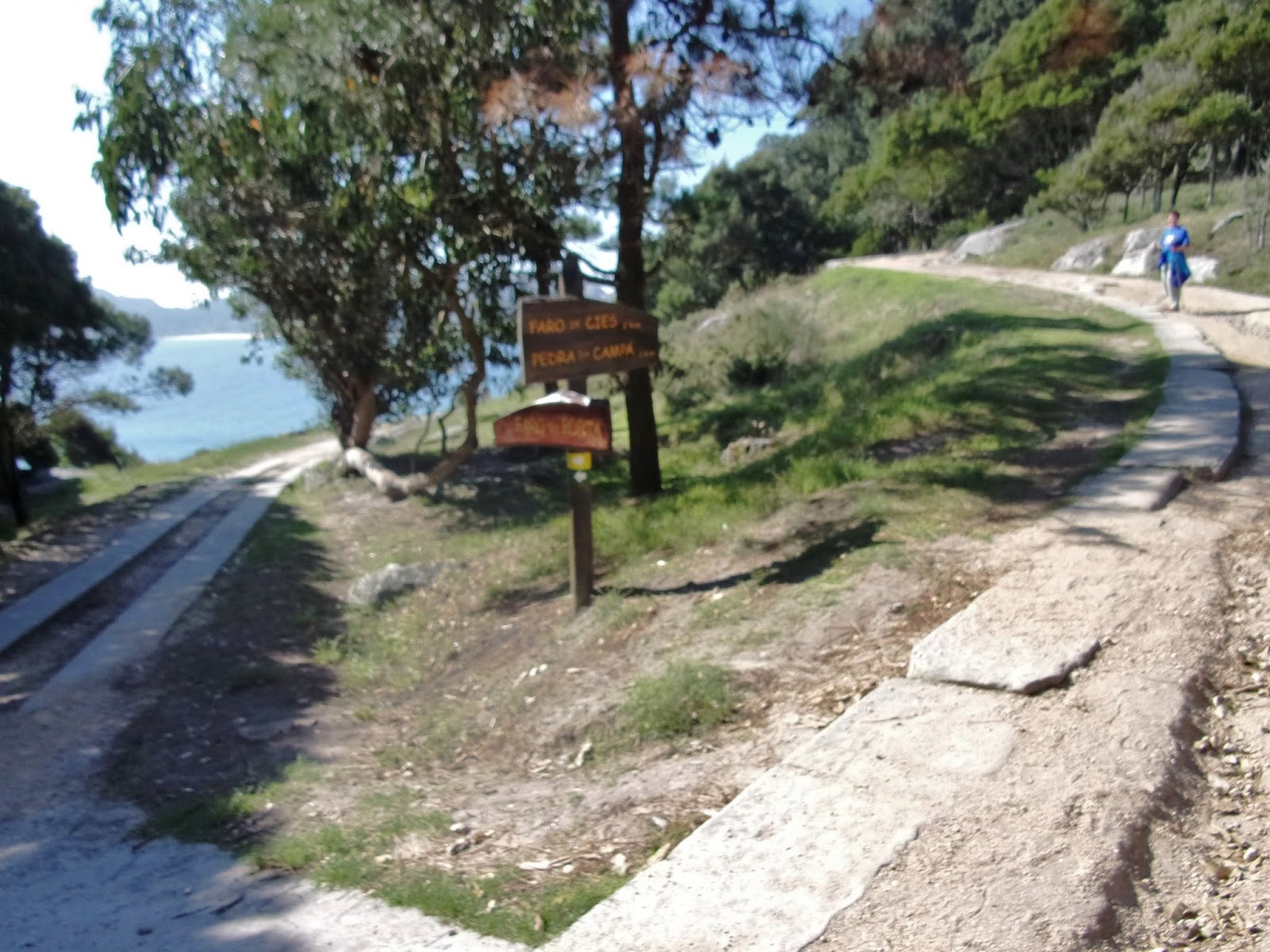
At 12:50, we started the 200 m detour to the Pedra da Campá [Stone of the Bell] lookout. The spectacular view was well worth it.

12:50 PM – Cíes: sign for turnoff to Pedra da
Campá overlook (200 m); sign at bottom points to Faro de Cíes (1.2 km).

12:51 PM – Cíes: MT on rocky path up to Pedra
da Campá.

12:53 PM – Cíes: Pedra da Campá - sign
pointing to Pedra da Campá to left, as we arrived at top of path.

12:55 PM – Cíes: Pedra da Campá – MT by big
rock with rectangular “window” in it (horizontal).

12:55 PM – Cíes: Pedra da Campá - MT by big
rock with rectangular “window” in it (vertical, telephoto 54 mm).

12:55 PM – Cíes: Pedra da Campá – MT climbing
back up from big rock with hole.

MT 12:58 PM – Cíes: Pedra da Campá – MT’s
photo through the rectangular hole in the rock.

12:58 PM – Cíes: Pedra da Campá – MT taking
her photo (Monte Faro in background).

1:01 PM – Cíes: Pedra da Campá – Monte Faro
and sea with breakers.

1:02 PM – Cíes: Pedra da Campá – foot of Monte
Faro with breakers; rocks on near cliff had yellow growth.

1:03 PM – Cíes: Pedra da Campá – view back
east toward Vigo.

1:05 PM – Cíes: Pedra da Campá – view to
north, of Illa do Monteagudo (Alto das Cíes at far end, then Monte Agudo and
Alto do Principe), bridge, lagoon, and Praia de Rodas beach (around the curve
at north end of the beach is our boat at dock and the bar); mainland in
background.

1:05 PM (Cropped) – Cíes: Pedra da Campá –
view to north cropped to focus on lagoon, Praia de Rodas beach, and our boat at
dock and the bar around the curve at north end of the beach.

1:09 PM – Cíes: Pedra da Campá – lookout booth
and yellow rocks.

1:06 PM – Cíes: Pedra da Campá – close-up of
lookout booth and yellow rocks.

1:05 PM – Cíes: Pedra da Campá – view from
lookout booth of foot of Monte Faro and breakers, with yellow rock.

1:06 PM – Cíes: Pedra da Campá – view from
lookout booth of foot of Monte Faro and breakers.
Around 1:18, we continued our climb, now becoming steeper, toward Faro do Cíes, arriving there around 1:41.


1:19 PM – Cíes: Near Faro do Cíes – path going
up to Faro do Cíes on right; (cross-over) path on left led down to Faro da
Porta.

1:21 PM – Cíes: Near Faro do Cíes – Illa de San
Martiño (South Island) and fishing boats, from path up to Faro do Cíes.

1:23 PM – Cíes: Near Faro do Cíes – first
sight of lighthouse with MT on curving path.

1:25 PM – Cíes: Near Faro do Cíes – still a
stretch of steep but straight path before the start of many switchbacks up to lighthouse
on peak.

MT 1:26 PM – Cíes: Faro do Cíes – Don on
straight path before switchbacks.

1:26 PM – Cíes: Near Faro do Cíes – near top
of straight path and clear view of switchbacks toward lighthouse on peak.

MT 1:28 PM – Cíes: Near Faro do Cíes – MT near
top of straight path (lighthouse in background).

1:27 PM – Cíes: Near Faro do Cíes – view of
Faro da Porta (bottom left) near east side of island, from much higher path to
Faro do Cíes (top right).

1:32 PM – Cíes: Near Faro do Cíes – view of
Faro da Porta and fishing boats between it and Illa de San Martiño, from much
higher path to Faro do Cíes (telephoto, 54 mm).

1:41 PM – Cíes: Near Faro do Cíes – view back
down path (many switchbacks near top, with railing only on curves, and
straighter path farther down; down below is the much lower path along the east
shore toward Faro da Porta.

1:41 PM – Cíes: Faro do Cíes – view of last
few switchbacks from top, with railing only on curves; on shore below is Faro
da Porta, with Illa de San Martiño across water.

1:41 PM – Cíes: Faro do Cíes – lighthouse.


1:45 PM – Cíes: Faro do Cíes – panoramic view
of Illa do Monteagudo, with yellow on rocks of cliff in foreground.

1:46 PM – Cíes: Faro do Cíes – starting back
down the switchbacks (Faro da Porta below right at the end of its path).
We crossed the bridge back onto Illa de Monteagudo around 2:45.

2:47 PM – Cíes: rocks in Ensenada do Lago water
to west of bridge at low tide; even the Lago drained back out to sea.

2:49 PM – Cíes: large fish in clear water in
Lago off east side of bridge.

2:53 PM – Cíes: view of Prais das Rodas and
dock from path through trees with exposed roots.

3:28 PM – Cíes: seagull among tables on terraza of bar by dock.

3:28 PM – Cíes: seagull among tables on terraza of bar by dock (telephoto, 76 mm).

5:09 PM – Cíes: speckled seagull on bar terraza; the white one was very
territorial and chased this one and another speckled one away (telephoto, 76 mm).
Don noticed that he could see MT out on the beach from the bar and took some telephoto pictures.

4:52 PM – Cíes: MT (in water) on Praia das
Rodas beach (telephoto, 112 mm).

4:53 PM – Cíes: MT on Praia das Rodas beach
(telephoto, 360 mm).

4:53 PM – Cíes: MT on Praia das Rodas beach
(telephoto, 360 mm).
At this point, Don walked out on the dock a little closer to the beach to get clearer photos.

4:57 PM – Cíes: MT on Praia das Rodas beach,
starting back toward dock (telephoto, 260 mm).

4:58 PM – Cíes: MT on Praia das Rodas beach,
going back (telephoto, 260 mm).

4:58 PM – Cíes: MT sadly leaving the water on Praia das Rodas beach
(telephoto, 260 mm).
We departed the Cíes dock after 5:50 (rather than the scheduled 5:30), but arrived in Vigo at 6:10.

4:54 PM – Cíes: view from dock back toward
Vigo.

6:11 PM – Vigo: view of city with Concatedral
de Santa Maria church (at left) as cruise boat neared the harbor.
We went straight to Café Bar El Bandoneón (small accordion for tango) for another of their great pizzas.

This time we settled for a medium pizza (with all the toppings listed on the menu except chorizo, bacon, tuna and pineapple) for 4.50€, plus a mixed salad (not on menu) and 2 glasses of (unidentified) red wine for a total of 13€. Before the salad and pizza, the owner brought us open-faced tuna sandwiches with our wine.

6:39 PM – Vigo: Café Bar El Bandoneón –
accordion (bandoneón) player mural
behind bar.

6:40 PM – Vigo: Café Bar El Bandoneón – our
tuna sandwiches and wine.
We picked up our backpacks at Hotel Vigo Plaza across the street and made it to the bus stop on Rúa Policarpo Sanz just in time for the 7:30 L9A bus to the airport. MT asked if it could stop at Hotel Avión (on Avenida Aeropuerto), but the driver said he stopped only at the airport, which was “lo mismo” (the same). When we arrived at the airport, we asked directions to the hotel from a uniformed man at the terminal door, and he told us to follow the bus 200m. After going around a left curve, we asked a man out running, and he told us to go another 300 m and then turn right. Before reaching that corner, MT asked a lady on the street, and she said we could see it from the corner.
We got to Hotel Avión at 8:24. The clerk charged 55€ for the double room; we asked about a pilgrim discount, and he said it was normally 66€ (MT later saw that Manuela’s son in Muxía had written down 50€). When MT asked if the hotel had a shuttle we could take to the airport in the morning (and had to explain what that was), the clerk said he would take us there in his own car. We asked for a wake-up call at 5:45 am.

MT 8:45 PM – Vigo: Hotel Avión – sunset from
our room.

9:24 PM – Vigo: Hotel Avión – Don’s 2 chestnuts
(left) and 2 acorns (right) before he threw them away.

928 PM – Vigo: Hotel Avión – Don shelled the
chestnuts before discarding.
No comments:
Post a Comment